Research Article, J Soil Sci Plant Health Vol: 3 Issue: 1
Dynamic of Soil Contamination in the Cities with Different Technogenic Impact
Mykola Miroshnychenko1*, Ivetta Krivitska2, Yevheniia Hladkikh3 and Maryna Zakharova4
1National Scientific Center “Institute for soil science and agrochemistry research named after O.N. Sokolovsky”, Ukraine
2Kharkiv National University named after V.N. Karazin, Ukraine
3Department of Agrochemistry, National Scientific Center “Institute for soil science and agrochemistry research named after O.N. Sokolovsky”, Ukraine
4National Scientific Center “Institute for soil science and agrochemistry research named after ON Sokolovsky”, Ukraine
*Corresponding Author : Mykola Miroshnychenko
Doctor of biological sciences, Deputy director, National Scientific Center “Institute for soil science and agrochemistry research named after O.N. Sokolovsky”, Ukraine
Tel: +38(057)704-16-69
E-mail: ecosoil@meta.ua
Received: July 05, 2018 Accepted: July 26 2018 Published: July 31, 2018
Citation: Miroshnychenko M, Krivitska I, Hladkikh Y, Zakharova M (2018) Dynamic of Soil Contamination in the Cities with Different Technogenic Impact. J Soil Sci Plant Health 3:1.
Abstract
Objective: The research was focus on monitoring heavy metals content in urban soils with different levels of technogenic impact, taking into account heterogeneity of soil cover and the functional purpose of land. Methods: Studies were carried out simultaneously in the two cities of Ukrainian (Berdyansk and Mariupol) on the Azov Sea coast, which significantly differ by the structure of industrial production. The area of each monitoring cities was at least 2500 m2, where were choosing 30 sites of baseline survey. On the each site the number of individual soil samples included in the mixed sample was 18-20. The time series of observations: 2002-2003, 2007-2008, 2012-2013. The available forms of heavy metals in the soils were determined by atomic-absorption method after extraction of buffer solution with pH 4.8 as well as 1 N HCl.
Result: Dynamics of soil contamination in the studied cities was significant different due to the reorientation of the industrial structure during the research period. In Berdyansk the level of soil contamination in the industrial zones gradually decreased, but heavy metals (Zn, Cu, Mn) began accumulate in soils of residential, cultural and administrative areas, in recreation objects. In contrast to this, due to the intensive activity of the enterprises of iron and steel industry in Mariupol the level of soil contamination in industrial, residential areas has increased by 8-18% and was higher than in Berdyansk in 1, 5-2 times. This is caused by the accumulation of Zn, Mn, Pb and mineral salts, sometimes in excess of the permitted rate.
Conclusion: Due to extremely high heterogeneity and combination of pollution from multiple sources, the changes of urban soil quality can be objectively assessed only by the systematic monitoring. The quality of urban soils is improving over five-ten years after reducing the amount of industrial pollution. Soil quality is deteriorating significantly in case of a constant dominance of steel industry over other activities.
Keywords: Urban soils; Contamination; Heavy metals; Monitoring; Dynamics; Spatial heterogeneity
Introduction
The increase in population is inevitably accompanied by the growth of cities and the expansion of the areas of urban land, which entails a deepening of environmental problems related to the quality of the urban environment. Since it is projected that 66%of the world population will live in urban areas by 2050, therefore the quality of urban soils plays an important role in the quality of life of the population. The soil cover in the cities increasingly loses the functions of the habitat and food production, in exchange it serves primarily as a basis for the objects of urban infrastructure and as a depositor of a variety of polluting substances [1,2]. According to FAO experts, the sealing of soils (screening by road and other coverings) is becoming the most threatening phenomenon in Europe, where the annual alienation of land under urban areas has reached 1,000 km2 in the last decade of the twentieth century and has a tendency to increase at the present time [3]. The state of unsealed urban soils is complicated by various types of physical impacts, a violation of the integrity of the soil cover, changes in water and salt regime, etc. As a result, the soil cover of modern cities has a very wide variety: from poorly transformed zonal soils to highly modified Urbozems and Technozems in the areas of extended settlement and industrial zones [4,5].
The aggravation of environmental problems in the cities stimulates the increased interest of local governments in obtaining objective information about the state of the soil cover and the projected risks for the population [6,7]. First of all, these are issues of valuation of lands taking into account their ecological status [8], as well as long-term planning of urban infrastructure [9], mitigation of soil sealing [10], planting of greenery [11,12], environmental control [13,14], etc. At the same time, the method of monitoring the state of urban soils is very far from perfect. It is especially difficult to correctly choose uncontaminated background soil and procedure for calculation [15,16]. It is proposed to use for this purpose survey data from large parks [17], surrounding agricultural land [18] as well as regional parameters for groups of soils with different textures [19] or an upper threshold value to contaminant domains [20]. In addition, monitoring of soil contamination with heavy metals should take into account the functional purpose of urban areas, sources and composition of contamination [21-23]. In connection with the above issues, the aim of this paper is to analyze the possibilities of heavy metals monitoring in cities with different levels of anthropogenic impact, taking into account heterogeneity of soil cover and the functional purpose of land.
Methods
Study area
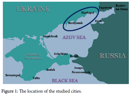
The studies were carried out by means of a comparative analysis of soil monitoring results in two cities on the Azov Sea coast: Berdyansk and Mariupol, which differ significantly in the structure of industrial production and, accordingly, in the level of man-made impact (Figure 1). Monitoring sites were located in industrial, administrative, cultural, residential and recreational zones of each city.
Earlier, Berdyansk was a well-known industrial city in the branches of engineering and chemistry, about 30 enterprises of the petrochemical, machine-building, light and food industries were located there. Last years the local authorities more tend to develop tourism instead industries which were at the soviet period. Last years the local authorities more tend to develop tourism instead industries which were at the soviet period. Thanks to the beautiful sand spit Berdyansk is attractive for tourists and due to famous healing muds it will able to be an international medical resort. The population of Berdyansk is about 132 thousand people; the total area of the city is 82.5 km2. The amount of industrial emissions to the atmosphere that accounts for one person is only 2.1 kg, which is much less than in Mariupol.
Mariupol is a major center of the metallurgical, machine-building and chemical industries of Ukraine. The population of Mariupol is about 500 thousand people, and the total area is 166 km2. The annual mass of industrial waste exceeds 9.5 million tons including 110-116 thousand tons of household waste. Emissions from enterprises to the atmosphere exceed 300 thousand tons per year which is equivalent to 600 kg per person.
Agreed to the local administration, the observations at monitoring sites were conducted in Berdyansk in 2002, 2007 and 2012. The same observations at monitoring sites in Mariupol were conducted in 2003, 2008 and 2013.
We chose regular sampling network with the distance between monitoring sites about 1 km, as far as possible in each city. The area of each monitoring site was at least 2500 m2, where were choosing 30 sites of baseline survey. On the each site the number of individual soil samples included in the mixed sample was 18-20. Depth of sampling: 0-10 cm with undisturbed addition of soil, 0-30 cm-when disturbed (on arable land).
Analysis methods
Content of heavy metals (Cd, Zn, Co, Ni, Fe, Mn, Cr, Cu) was measured for mobile (using extraction of buffered ammonium-acetate solution with pH 4,8) and available (extraction 1 N HCl) forms by atomic-absorption spectrophotometry. The content of organic carbon in the soil was measured according to ISO 10694:1995 [24], and pHaccording to ISO 10390:2006 [25]. The content of heavy metals in grass vegetation and phytotoxicity of soil was determined in 50% of monitoring sites.
Data were expressed as mean values ± SE. Statistical analyses were carried out using Statistica 10. The statistical analysis that was performed including correlation and regression methods, the method of graphic images.
Results and Discussion
Differences of soil cover
Before settling, the soil cover of the surveyed territory was formed of two types. The terrain at an altitude of 40-50 m above sea level was covered with loess rocks on which áhernozems Calcic formed. Calcic this kind of Chernozems contents physical clay 50-66 %, organic Carbon in the upper horizon 2.2-2.7%, pH from 7.2 to 8.0. The parent rocks of these soils predominantly consist of carbonate loess-like clays and loams, 6 to 50 m thick, containing from 4% to 17% CaCO3. The high content of humus and clay minerals in Chernozems Calcic contributes to the increased adsorption of cations of heavy metals by the soil absorbing complex, while the slightly alkaline reaction of the soil solution and the CO32- anions lead to precipitation of their hydroxides and carbonates.
Soils on marine and alluvial river sedimentary rocks formed in lowered elements of the landscape. In contrast to áhernozems, soils on the sea and river rocks contain very low amount of the clay material, therefore, they are not able to hold the contaminants. Anthropogenic activity has significantly altered the soil cover, further increasing its heterogeneity, but the differences in the buffer capacity of the two types of soils can be clearly seen at the present time.
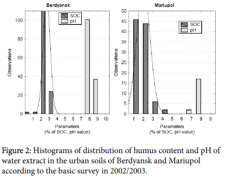
Thus, in each city there is a high part of the territory where the soils are resistant to contamination and a lower part with less stable soils. As can be seen from the histogram of the frequency of occurrence of humus and pH parameters (Figure 2), along with well-humified Chernozems, low-humus soils are also found. At the same time, weakly alkaline conditions predominate in the reaction of water extract in the soil cover of both cities.
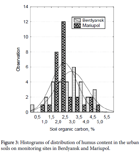
As is known, organic matter is closely related to clay minerals and characterizes the adsorption capacity of the soil. In turn, pH shows the ability of the soil to precipitate hydroxides and carbonates of heavy metals. Therefore, low-buffered soils with a low content of organic carbon and clays, as well as soils with the lowest pH, should first of all be included in the list of monitoring objects. As a result, we obtained a similar distribution of organic carbon content as the most variable indicator of soil buffering (Figure 3).
Forming of monitoring network
Location of monitoring sites on the major sources of emissions of pollutants is even more important criterion for selecting their locations among the urban infrastructure. It is known that the distribution of pollutants is determined by the height of the pipes and the phaseaggregate composition of the aerosols. Slightly soluble larger particles settle on the soil surface in the vicinity of the source of emission, and the more soluble fine particles are scattered over a considerable distance [26]. With this in mind, only 20%of monitoring sites were located on the territory of administrative, residential and recreational areas, the remaining 80% were located in industrial zones. It was expected that the formed monitoring network would represent representative changes in the state of urban soils in time, in particular, related to pollution.
Finally, high level of heterogeneity of urban soils as well as frequent repair and construction work complicate soil monitoring in a city. Due to the extremely large heterogeneity, anthropogenically transformed soils often reflect the influence of random factors more than the temporal dynamics. This feature of urban soils causes the need to take appropriate measures. First of all, it is necessary to increase the number of individual samples for the formation of a composite representative sample due to the high probability of coincidence of the place of taking one of them with a small spot of contamination. According to ISO 10381-5 [27], it is recommended to take from 15 to 30 individual samples in the case if model of spatial dissemination is unknown. Vazhenin [28] considered that number of individual samples for composite one should be even more: from 40 to 60. Naturally, rising of points quantity links to representativeness, and, at the same time, probably of random contaminated spot is increasing. The national standard of Ukraine [29] requires taking 20 individual samples as minimum.
In 2002/2003, the baseline survey showed that the natural background content of heavy metals is significantly different in soils of different genesis and properties. For example, Fluvisols Eutric on floodplains contained mobile Cd around 0.05 ppm, Co 0.45 ppm, Ni 0.30 ppm, Cu 0.20 ppm, and the immediate vicinity Chernozems Calcic-0.25; 1.10; 1.55 and 0.43 ppm, respectively. In this regard, the 2002/2003 data were taken as a reference point for comparing different observations at each of the monitoring sites. To avoid the influence of a random factor, trends in soil quality change were identified on the basis of several monitoring sites combined by location or use. This approach allows us to make statistically more substantiated conclusions and to compare changes in different urban areas or on lands with different uses.
Calculation of background concentrations
According to the national standard, the urban background values were calculated for the both of cities, as a median value of the content of heavy metals in the collected soil samples (Table 1). Geochemical data rarely follow a normal distribution [15]. Therefore, the median delivers the most freedom from extremal values.
| Elements | Content of available heavy metals in the top of soil, ppm | |||
|---|---|---|---|---|
| Berdyansk | Mariupol | Surrounded lands | Official permissible levels | |
| Zn | 1.5 | 5.1 | 0.8 | 23 |
| Cd | 0.3 | 0.45 | 0.19 | - |
| Ni | 1.6 | 3.5 | 1.9 | 4 |
| Co | 1.7 | 3.2 | 1.3 | 5 |
| Fe | 3 | 6.5 | 2.4 | - |
| Mn | 14.8 | 16.8 | 8.7 | - |
| Pb | 6.1 | 11.7 | 4.2 | - |
| Cu | 0.6 | 1 | 0.38 | 3 |
| Cr | 0.77 | 0.85 | 0.35 | - |
Table 1: Median value of the available heavy metals content in Berdyansk and Mariupol.
This data show that the content of heavy metals in Berdyansk’s urban soils is more than on the surrounded agricultural lands. Soil cover of Mariupol is much more contaminated than Berdyansk (in 1,5-3 times). Currently, official permissible levels set for 4 heavy metals: Zn (23 ppm), Co (5.0 ppm), Ni (4.0 ppm), and Cu (3.0 ppm). The content of available Ni and Co is approaching to the abovementioned permissible levels. This is due not only to the incoming nickel and cobalt from industrial sources, but also to the natural accumulation of these elements in coastal landscapes.
Dynamic and dissemination of pollutants
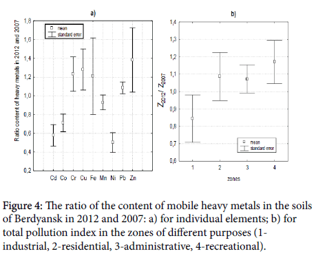
From 2007 to 2012, the content of most studied elements in the urban soils of Berdyansk tended to increase (Figure 4a). The average content of mobile Cr, Cu, Fe increased by 20%, Zn by 40%, but content of Cd, Co and Ni are decreased. Thus, priority of pollutants changed. We associate these changes with the reorientation of the city to tourism and recreation. The grouping of monitoring sites according to the functional purpose of the land shows that there is a gradual decrease of soil contamination in industrial zones due to migration of heavy metals (Figure 4b). We observe the accumulation of heavy metals in areas of residential development, cultural and administrative places and, especially, recreational facilities. Consequently, the content of such typically technogenic elements as cadmium and nickel decreases and biogenic elements such as zinc, copper, manganese tend to accumulate.
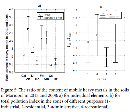
Comparison of the content of mobile heavy metals at monitoring sites in Mariupol shows much greater variability (Figure 5). The main reason is a much stronger man-made load on urban landscapes, which leads to an increase in soil heterogeneity. In general, the content of mobile Co, Cu and Cr in soils in 2013 decreased, which is probably related to the soil alkalization. The average pH of water extract increased from 7.9 (range 7.8-8.1) in 2008 to 8.7 (range 8.4-9.3) in 2013. It is obvious that the mobility of cationic heavy metals has fallen sharply in alkaline solution. Nevertheless, the content of other heavy metals, especially such as Zn, Fe, Mn, Ni, was increased significantly. As we have assumed this direct link to activity of steel enterprisers in Mariupol. As Zhukov MN et al. [30] have recently determined, Zn and Cu are characterized the most technogenic origin in the soil layer 0-5 cm there.
The accumulation and dissipation of heavy metals in zones of different functional purpose in Mariupol have a different trend than in Berdyansk. Due to intensive activity of metallurgy enterprises and other sources of heavy metal emissions, the level of total pollution increased by 8-18% on industrial lands, residential areas and city parks. First of all, this was due to the accumulation of zinc, manganese and lead, the content of mobile forms of which at certain sites exceeds the maximum permissible level.
Conclusions
Urban soils are an extremely difficult subject for monitoring. The reason is the high heterogeneity of soil cover in a city and overlapping of effects from many pollutant sources. Therefore, an objective characterization of changes in the state of urban soils might only be obtained by means of space-time observations. Such monitoring system, organized in two seaside cities with different technogenic impact, shows changes in the distribution of heavy metals around industrial enterprises. In the case of significant declining of industrial activity as it was happened in Berdyansk, the quality of urban soils is improving over 5-years period but heavy metals are continuing to dissipate from the industrial zone to the surrounding land. On the other hand, in case of a constant dominance of the steel industry over other businesses, as it happened in Mariupol, soil quality is deteriorating significantly for the same period.
Acknowledgements
This research was supported by Berdyansk City Council (2002, 2007, 2012) and Mariupol City Council (2003), as well as projects of the National Academy of Agrarian Science of Ukraine (0106U002944; 0111U002965).
References
- Lal R, Stewart BA (2017) Urban soils. CRC Press, USA.
- Dobrovolskiy GV (1997) Pochva, gorod, ekologiya (Soil, City, Ecology), Moscow, Russia.
- ITPS (2015) Status of the world’s soil resources. FAO, USA.
- Stroganova M, Prokofieva T (2000) Urban soils concept, definitions, classification. Proceedings of First International Conference SUITMA, Germany.
- Prokofieva T, Gerasimova M, Lebedeva I, Martynenko I (2013) An attempt of integrating the systematic of urban soils into the new russian soil classification system. Soil Sci Ann 64: 24-29.
- Blümlein P, Medved P, Vernik T, VršÃ„Âaj B (2012) Soil in the City. Urban Soil Management Strategy (2012) Final brochure of the project of Central Europe Programme. Stuttgart, Germany.
- Dunbar MB, Panagos P, Montanarella L (2013) European Perspective of Ecosystem Services and Related Policies. Integrated Environment Asses Manage 9: 231-236.
- Stoma GV (2016) Ecological status of soils and tree plantations of residential landscapes in Moscow. Moscow Univ Soil Sci Bull 71: 35-41.
- Poggio L, VršÃ„Âaj B, Hepperle E, Schulin R, Marsan FA (2008) Introducing a method of human health risk evaluation for planning and soil quality management of heavy metal-polluted soils - An example from Grugliasco (Italy). Landscape and Urban Planning 88: 64-72.
- http://ec.europa.eu/environment/soil/sealing.html
- Burghardt W, Morel JL, Zhang GL (2015) Development of the soil research about urban, industrial, traffic, mining and military areas (SUITMA). Soil Sci Plant Nutriti 61: 3-21.
- Jim CV (2001) Managing urban trees and their soil envelopes in a contiguously developed city environment. Environment Manage 28: 819-832.
- Qing X, Yutong Z, Shenggao L (2015) Assessment of heavy metal pollution and human risk in urban soils of steel industrial city (Anshan), Liaoning, Northeast China. Ecotoxicol Environmental Safety 120: 377-385.
- Mugoša B, Dubrović D, Nedović-Vuković M, Barjaktarović-Labović S, Vrvić M (2016) Assessment of ecological risk of heavy metal Contamination in coastal Municipalities of Monrenegro. Inter J Environmental Res Public Health 13: 393.
- Reimann C, Filzmozer P, Garrett RG (2005) Background and threshold: critical comparison of methods of determination. Sci Total Environment 346: 1-16.
- Chernova OV, Beretskaya OV (2011) Permissible and background concentrations of pollutants in environmental regulation (heavy metals and other chemical elements). Eurasian Soil Sci 44: 1008.
- Obukhov AI, Lepneva OM (1996) Biogeochemistry of heavy metals in urban environment. Pochvovedenie 5: 65-73.
- Elberling B, Breuning-Madsen Y, Hinge H, Asmund G (2010) Heavy metals in 3300-year-old agricultural soils used to assess present soil contamination. Eur J Soil Sci 61: 74-83.
- Bini C, Sartori G, Wahsha M, Fontana S (2011) Background level of trace elements and soil geochemistry at regional level in NE Italy. J Geochem Explor109: 125-133.
- Ander EL, Johnson CC, Cave MR, Palumbo-Roe B, Nathanail CP, et al. (2013) Methodology for the determination of normal background concentrations of contaminants in English soil. Sci Total Environment 454: 604-618.
- Linde M, Bengtsson H, Öborn I (2001) Concentrations and pools of heavy metals in urban soils in Stockholm, Sweden. Water, Air, and Soil Pollution 1: 83-101.
- Marjanović MD, VukÄÂević MM, Antonović DG, Dimitrijević SI, Jovanović DM et al. (2009) Heavy metals concentration in soils from parks and green areas in Belgrade. J Serbian Chem Society 74 : 697-706.
- Balyuk SA, Miroshnichenko NN, Fateev AI (2008) Concept of ecological rating of permissible anthropogenic impact on the soil cover in Ukraine. Eur Soil Sci 41: 1327-1334.
- Soil quality (1995) Determination of organic and total carbon after dry combustion (elementary analysis). 10694.
- Soil quality (1994) Determination of pH. 10390.
- Wuana RA, Okieimen FE (2011) Heavy metals in contaminated soils: a review of sources, chemistry, risks and best available strategies for remediation. International Scholarly Research Notices Apple Academic Press, Canada.
- Soil quality (2005) Sampling -Part 5: Guidance on the procedure for the investigation of urban and industrial sites with regard to soil contamination. 10381-10385.
- Vazhenin IG (1987) Methodological recommendations on soil cover survey and mapping in terms of pollution levels by industrial emissions. Moscow, Russia.
- Soil quality (2011) Technogenically polluted land. Examination and use. 7243.
- Zhukov MN, Kuraeva IV, Voytyuk YY, Stakhiv IR, Bunina AY, et al. (2015) Comprehensive estimation of contamination of the Mariupol city soil by the method of main components. Geoinformatika 3: 60-67.
 Spanish
  Chinese
  Russian
  German
  French
  Japanese
  Portuguese
  Hindi
Hindi 