Review Article, J Comput Eng Inf Technol Vol: 12 Issue: 6
A Comprehensive Study of Smart Ambulance Management System
Prasad KSN, Kavya Tulasi M*, Murali K, Sai Teja K and Ajay Manohar M
Department of Computer Engineering, Sasi Institute of Technology and Engineering, Andhra Pradesh, India
*Corresponding Author: Kavya Tulasi M
Department of Computer Engineering,
Sasi Institute of Technology and Engineering, Andhra Pradesh, India,
Tel: 9347764313;
E-mail: kavya590@sasi.ac.in
Received date: 26 January, 2023, Manuscript No. JCEIT-23-87966;
Editor assigned date: 30 January, 2023, PreQC No. JCEIT-23-87966 (PQ);
Reviewed date: 13 February, 2023, QC No. JCEIT-23-87966;
Revised date: 18 April, 2023, Manuscript No. JCEIT-23-87966 (R);
Published date: 25 April, 2023, DOI: 10.4172/2324-9307.1000273
Citation:Prasad KSN, Tulasi MK, Murali K, Teja KS, Manohar MA (2023) A Comprehensive Study of Smart Ambulance Management System. J Comput Eng Inf Technol 12:3.
Abstract
According to the UN, the population of the cities will double during the next 30 years. This rapid growth raises serious problems in the central sections of both traditional and smart cities. One of the key areas of concentration for managers and directors of smart cities is enabling a clean, healthy, and sustainable environment in order to improve the living conditions of individuals who reside there. Smart health is one of the essential elements of the smart city and may be particularly useful for assisting patients when they need it. This research aims to address a current issue with a smart ambulance management system in a smart city context. If the patient needs an ambulance, the operator finds the nearest one and points it in the direction of the patient; the ambulance then transports the patient to the hospital using the quickest route. The technology uses google maps as a third party service to find the shortest path to the victim while dynamically tracking the whereabouts of ambulances. Following their arrival at the patient, the expert (a doctor or nurse) investigates the issue and employs the provided strategy to identify the ideal hospital that is nearby. The results of the trial showed that the proposed approach quickly locates the best solution.
Keywords: Smart ambulance; Shortest path; Ambulance deployment; Ambulance management; Smart health
Introduction
India lags behind other countries in providing emergency medical assistance. Traffic congestion is now a major issue and a difficulty in major cities due to the increasing population and number of people and vehicles [1]. As one person in India dies every minute from a serious illness or a virus, there is also the additional factor of a patient's inability to get quickly and efficiently to the hospital. Due to the ambulance services' lack of emergency response [2]. When rescue vehicles attempt to navigate traffic congestion, it can potentially be fatal. Along with hurting the economy, traffic congestion can substantially impair emergency services such as ambulance, fireman, and police response times and quality of service. For the benefit of the ambulance driver and the general public, we are creating an android application called ambulance service. We have plotted patient information on google maps of the smartphone using Global Positioning System (GPS) and google map Application Programming Interface (API). Additionally, it controls through alert messages sending directly to the user [3].
The frequent occurrence of accidents, medical problems, and other occurrences, such as fires and car accidents. To avoid major human casualties, it is crucial that rescue vehicles reach on time. In order to speed up reaction times in case of such situations, hospitals are spread out throughout the city. Cities have had extremely rapid population increase, which has led to extremely heavy citywide traffic [4]. Additionally, the frequency of fatalities caused by emergency vehicle arrival delays has increased significantly in recent years. Therefore, in order to prevent the loss of human life, emergency services like ambulances and fire engines must arrive on time. Therefore, assisting an emergency vehicle to escape traffic is a crucial objective in the current traffic situation. To address the existing challenges. In this study, we present a solution for smart ambulances and traffic management systems. This device's primary function is to let the ambulance travel directly to its intended destination without having to stop along the way, so that there is no delay of taking the patient to hospital [5].
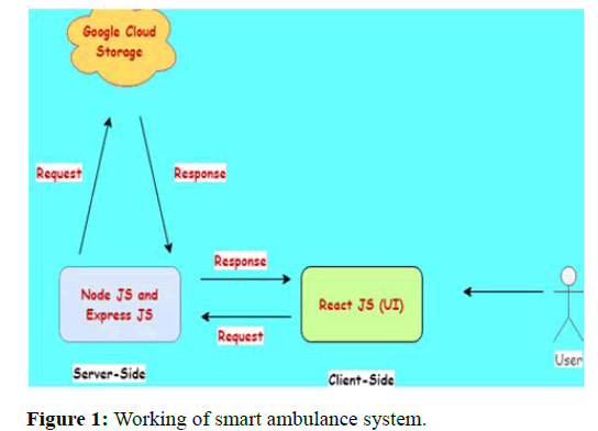
A decision is made automatically by an expert system. A computer based expert system independent of various applications was developed to design this system. This information has a wide range of practical applications. We discuss the creation of an automated expert system for ambulance management in our system. By dialing a specific caller number, the patient can contact the expert system, which will then make decisions regarding the delivery of ambulances. The patient's name, current address, and health information are automatically retrieved from the database by automated expert systems. The system also monitors the patient's present location. The system will check whether there are many ambulances in the hospital after identifying the patient's information. The technology will then quickly send an SMS to a specific and nearest ambulance driver's cell phone. So, the ambulance gets to the patient quickly [6]. Getting the ambulance to an accident prone area and picking up the patient at the correct time and taking the patient to the hospital in the shortest path is efficient (Figure 1).
Challenges observed in the proposed expert ambulance management system
Location accuracy: The caller frequently provides an inaccurate location to the operator, which may cause a long delay. The caller can attempt to provide the operator with a location by naming a wellknown landmark that they know. In addition, the ambulance driver might not be aware of the quickest route through current traffic to get to the specified area or hospital.
Operator centered: In the existing arrangement, phone calls to the operators are answered by the operators. To acquire all the information required about the patient and geographical specifics, this system needs a lot of time and human labor. Even if the number of emergency cases has increased, adding more operators is neither profitable nor practical.
Managing a large number of callers: In an operator centered environment, it is challenging for the operators to reply to every caller when there are a lot of calls coming in at once. In such cases, the system's efficiency suffers since fewer clients are being served, which reduces system performance.
Report generation and analysis: Because the system is paper based, creating interactive weekly or monthly reports will take a lot of work and time from humans. It is challenging to analyze the reports and efficiency. Additionally, because we don't have data backups, the data will be lost in the event of a calamity.
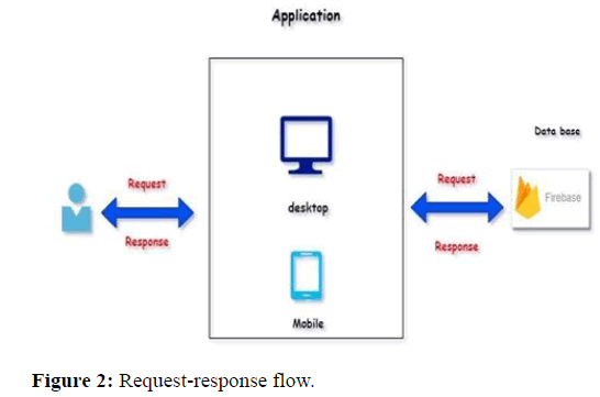
Figure 2 represents the request-response flow of smart ambulance management system.
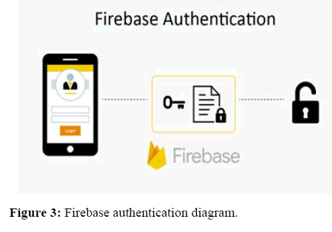
Figure 3 represents the fire-base authentication of smart ambulance management system.
Finally this concept transmits real time health data about the patient to the hospital the user has chosen. The system, which will be available inside the ambulance, will capture the readings using a variety of smart device support enabled hardware components. The software will provide data in the form of real time feeds so that hospital administration can take the appropriate precautions before the patient ever arrives at the hospital. In the event of any heart related emergency or condition, it is believed that the treatment provided while transporting the patient from the originating location to the hospital is of utmost importance. Thus, a hospital administrator can direct what steps should be taken up until the patient arrives at the hospital.
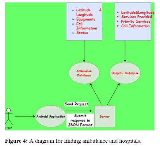
Figure 4 suggests the user sends requests to the server regarding the required service i.e. either hospital information or ambulance details.
General architecture diagram
Giving emergency services in less time demonstrates the best performance. Emergency hospitals will be at their best if the ambulance arrives at the scene during the golden hour when injured people's lives can be saved. The ambulance travels by road to the accident site. The dispatcher will use the new system to handle the dispatching operation. The system allows ambulances to be dispatched and also locates patients. The following section describes the system's major high level functions.
Google has created an API for user convenience. Google maps provides details about hospitals in the area, including their rating and proximity to the user's present location. Google maps flaw is that it just highlights hospitals without providing any additional details. Therefore, a user may need to visit a specific hospital's website in order to get information about the facility.
This disadvantage is overcome by the smart ambulance system application, which also provides hospital information regarding the user's medical emergency. It is a routine that effectively provides information about the patient's health, such as their pulse and blood pressure. Additionally, it immediately informs on the relevant pharmaceuticals and medications. The doctor and the patient's career are informed on everything regarding the patient's health. All of these interactions are managed by the Ambient Assisted Living (AAL) system.
Mobile devices, on the other hand, have the ability to receive notifications or emergency alerts. In the context of emergency transportation, they can be utilized to maintain the drivers' awareness of their surroundings. Today, practically all mobile devices come equipped with the GPS service, which can be used for locating and routing needs. It can be applied to fill the need for emergency routes to be highlighted. In this situation, paramedics and drivers won't need to set up any additional gear in order to be informed of emergency routes; instead, they can utilize their own handheld mobile devices. In this article, we suggest a smart ambulance system that will inform drivers of the emergency routes that ambulances choose to take. The system attempts to develop the infrastructure for ambulances and is a sort of smart healthcare emergency application. When an emergency route is chosen, cars are alerted to make room for an ambulance before it arrives. The user emergency application and the paramedic application are two of the system's two components. By displaying the patient's position and providing access to emergency routes and ambulance locations, the user emergency application enables them to order an ambulance(s). Additionally, the paramedic application helps paramedics find the patient(s) and the right hospital.
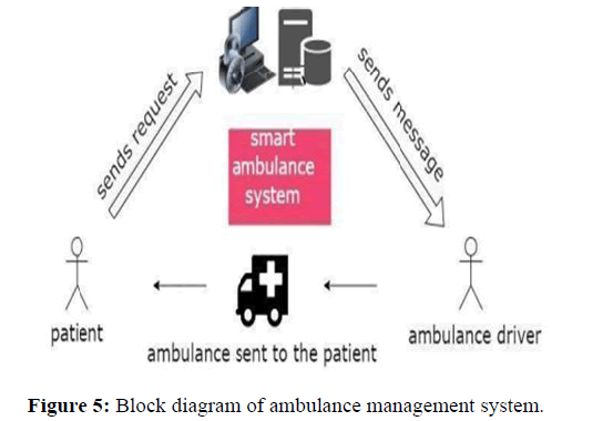
The major objective is to transform the ICU unit into a smart space at the hospital. Here, a slight adjustment or the therapies used at the time could result in significant alterations. A smartphone application reads the server response, retrieves the necessary data, and either uploads it to the google map client on the device or displays it in a list format based on the preferences of the user. A marker is used to pin \point the location of retrieved data is known as pin. We've used customised pins to distinguish between pins that are used for pointing hospitals and ambulances. Even a novice user will find it simpler to understand the differences. The capabilities of the google map API can be used for this. Google makes a set of preconfigured markers available through their google map API. Custom pins are employed, nonetheless, for the convenience of the user. Google maps manual also includes such API etiquette. The below Figure 5 shows the working of the smart ambulance system.
Literature Review
Several solutions for improving the ambulance system and emergency services have been proposed in papers [7-10]. This section looks at existing proposed solutions that are related to our research.
Many of them were constructed after the year 2000. Some of the projects that offered various solutions shared goals with the smart ambulance. Those who had done enough research in the literature were far from the state of technology today. Smart city applications and their connections with systems are among the general topics examined and investigated. It is necessary to deal with these reviews in layers. The studies for smart cities system, software, hardware, availability, durability, stability, and maintainability were reviewed.
Athavan, et al., proposed that in case of an accident, the main server searches and finds the nearest ambulance, the nearest hospital, and the accident spot. Then the server sends the minimal path to the ambulance to reach the patient’s side by using Dijkstra's algorithm [11]. The nodes in the shortest path are accessed and controlled only when the ambulance reaches a distance of around say 1 km from the node. The locations of 1 km markings are taken from the map and stored in the database.
Sankar proposed a model that detects the accident instantly in order to reduce patient transportation time while also preventing ambulance delays, and manages ambulances to direct them to the accident site [12]. When an accident occurs, the in vehicle module notifies the main server, and the server determines the best route for the ambulance. The application will assist the ambulance driver in reaching the patient as soon as possible. This reduces transportation time while increasing the rate of saving human lives.
The computation of the optimal route to move from one place to another is a highly important problem in road networks. The problem consists of finding the path that minimizes a metric such as distance, time, cost, etc. to move from one node to another in a directed or undirected graph [13]. Several algorithms have been developed to compute shortest paths since 1956. Dijkstra's algorithm is one of the standard solutions to solve the one-to-one shortest path problem. Bellman-Ford algorithm is a shortest path finding algorithm that is used in graphs containing negative edge weights along with the positive edge’s weights. Floyd-warshall algorithm computes the shortest paths between all pairs of points in a weighted graph. If we have several possibilities to go from one place to another usually makes us incapable of finding the best route out. So route planning has gained significant importance in recent years.
M. T. Jilani, et al., proposed that trauma is the main reason for death in metropolitan cities. The delay in delivering patients to the hospital badly affects the trauma. Their work explains a frame for the emergency event reporting system, which detects nearby persons and their smartphones, and aggregately notify emergencies [14]. The system that processes the received information and sends the route to the patient and the nearest hospital information to the ambulances in order to provide better solutions.
Karthikeyan, et al., proposed that hospital overcrowding has been a problem in the public healthcare system [15]. The main cause of this problem is the limited available resources, including a limited number of doctors, nurses, and the limited capacity and availability of medical devices. There have been attempts to alleviate the problem through various strategies. In this paper, a low cost system was developed and tested in a public hospital with a limited budget. The system utilized a QR code and smartphone application to capture as is hospital processes and the time spent on individual activities. With the available activity data, two algorithms were developed to identify two quantities that are valuable to conduct process improvement: The most congested time and bottleneck activities. The system was implemented in a public hospital and results were presented.
Zhen, et al., investigated the decision rules for ambulance scheduling in a dynamic environment [16]. The study looks at the design of decision rules to ensure a high percentage of ambulance vehicles respond within fifteen minutes, which is critical for control centers. As a result, the authors created several ambulance scheduling decision rules to ensure that the ambulance arrives within 15 minutes to address the emergency request in a timely manner.
Noraimi Azlin Mohd Nordin, et al., introducing Emergency Medical Services (EMS) ambulance which is designed to give medical care or treatments to the patient at the emergency sites if needed. Else they are directly sending the patient to the hospital. Here, the star algorithm is used for routing purposes [17].
Ashmawy, et al., presents an integrated platform that provides the best route for ambulances and monitors patient status until they arrive at the hospital [18]. The platform's goal is to reduce the likelihood of death by hastening the arrival of an ambulance to the casualty and providing vital patient data to the doctor in charge of saving the injured patient. Furthermore, the doctor can use the platform to inform and direct the paramedics, as well as learn the paramedic's initial evaluation and observation. As a result, the doctor and hospital can prepare the necessary personnel and materials. In addition, the platform analyzes data using machine learning to reinforce the decision making process in their work.
Lohokare, et al., proposed a real time solution for displaying the location of emergency services [19]. The goal is to overcome existing systems' limitations in handling large amounts of data in smart city settings and to enable citizens to quickly connect to the nearest accessible emergency services providers, such as ambulances. Emergency responders will use GPS systems embedded in smart phone devices or low cost custom devices to update their live location to a server. As a result, the user can contact the nearest emergency provider whenever necessary. The proposed solution's evaluation results demonstrated its dependability and the ease with which citizens could access emergency services.
Mari Muthu, et al., proposed a mobile application that would provide efficient ambulance services. The idea is to allow users to request an ambulance and select their hospital [20]. Based on the patient's location, the proposed system can dispatch the nearest ambulance. The proposed ambulance services concept includes a GPS and GSM module. The GPS component is used to locate the ambulance, and the GSM component is used to transmit data.
Bhajantri, et al., proposed an ambulance tracking system to keep hospitals informed of the arrival of an ambulance. The system's goal is to keep doctors and nurses ready to provide emergency care once the ambulance arrives at the hospital. The system uses GPS hardware to pinpoint the location of the ambulance in real time. It provides additional monitoring services such as the patient's heartbeat and temperature.
Solution comparison
The fastest way to complete the application was critical for us. As a result, it has reduced the duration calculations, such as determining the fastest route, to a bare minimum. To make sure, this method takes the hospital locations from the database and lists the hospitals closest to the patient (within the range that is already determined) and the quickest way to reach them. It calculates direct distance first, then uses google API to request matrix distance. Calculation processes are listed in a list and take about 2 seconds. Search is making an application that can work on all Android versions. The app is compatible with both iOS and Android. Flutter offers a large platform with high stability. The haversine method and the Google distance matrix API were used to search among 150 hospitals in Istanbul. After attempting numerous methods, 2 seconds was determined to be a success. The algorithm compares the distance and duration between the ambulance and the patient, as well as between the ambulance and the hospital. If the hospital number is 150 or higher, the tested search spectrum is between 2 seconds and 3 seconds. The method used takes the user's location and calculates as the crow flies. The second step is to use Google distance matrix API if the distance between locations is less than 10.000 km.
It helps users in emergency situations by saving time that would otherwise be spent trying to get an ambulance through other means. Finding the right hospital for the patient's treatment is aided by the information offered about the institutions. The hospital personnel can better prepare for the therapy by receiving the patient's health information. In this instance, there is never a need for the patient to wait. There is no need to visit the specific hospital's website because information is simply provided by the maps. Live broadcasts will aid in more effective medical operations that will effectively save patients' lives.
The goal of this study is to design and implement an ambulance system in hospitals. This project will address the shortcomings of the manual system. Using the expert system, users can register their information, manage ambulance availability, send patient information to the driver, generate reports, maintain patient information, and receive feedback from other users.
The Table 1 says about the study of comparing existing models. The table involves columns like authors, algorithms and relationship between parameters. The authors column describes the name of the author and year of publication. The algorithm/methods column describes the name of the algorithm used by authors. The parameters are GPS navigation, shortest path, and traffic conditions. The relationship describes whether that parameter is used in that algorithm or not.
| Authors | Algorithm/methods | GPS navigation | Shortest path | Traffic parameters |
|---|---|---|---|---|
| Chowdary, et al. | A rescue system of an advanced ambulance using prioritized traffic switching. | No | No | Yes |
| Karthikeyan, et al. | Smart ambulance for traffic management system. | No | No | Yes |
| Lim, et al. | Impact of ambulance dispatch policies on performance of emergency medical services. | No | Yes | No |
| Derekenaris, et al. | An information system for the effective management of ambulances. | Yes | Yes | No |
| Swaty, et al. | Accident alert and ambulance tracking system. | Yes | No | No |
| 6 | Proposed system | Yes | Yes | Yes |
Table 1: Comparison of existing models.
The Table 2 describes parameters and their attribute types. There are three different types of parameters observed in the parameters information Table 2. The parameters are 2 types i.e. the parameters taken after an accident and before an accident. The attributes are of three types they are namely number, latitude longitude and text. The information gathering is also one of the parameter while considering the Table 2. A refers to data collecting after accident. B refers to data collecting before accident.
| Parameters | Attribute type | Information gathering |
|---|---|---|
| Ambulance number | Number | B |
| Ambulance current location | Latitude and longitude | A |
| Patient name | Text | A |
| Patient blood group | Text | A |
| Ambulance allocated area | Text | B |
| Accident location | Latitude and longitude | A |
| Hospitals list | Text | B |
| Driver name | Text | B |
Table 2: Parameters information for ambulance management system.
Discussion
From the results and analysis no method that satisfactorily incorporates all the qualities, as evidenced by the table of scores. Therefore, there are some limitations in algorithms mentioned. Including all the parameters can increase the efficiency of ambulances to reach patients in a shortest time and shortest path.
Conclusion
In this study, our goal was to transport the casualty and quickly to the patient who needs an urgent intervention to the best hospital for the necessary interventions. In the firebase database we built for these purposes, we have designed an interface that displays hospital data and ambulance locations online so that whenever a patient call is received, the nearest ambulance admin user will be pointed in the right direction.
In order to expedite the processes once the ambulance arrives at the patient, we keep records of the hospitals' locations and the types of interventions that can be performed in our database. With the help of this filtering feature, we were able to arrange the best hospitals according to how quickly they could be reached. When taking into account the reaction and transportation times, this investigation has yielded successful outcomes. More data can be gathered from hospitals and other high tech IoT components, such as smart traffic devices, to improve this project. This project proves that human life is more valuable than anything else, and that the more people that step in to rescue lives, the more lives will be saved. A publish-subscribe based communication system can be set up for usage in multifunctional applications, and ambulances can be accepted as sensors. Additionally, the position of the ambulances can be picked using intelligent algorithms that have the best coverage regions.
References
- Arunachalam PL, Krishna P, Vignesh M, Thomas TS (2021) Ambulance booking application. 6th International Conference on Signal Processing, Computing and Control (ISPCC), pp. 146-149.
[Crossref]
- Abdeen M, Ahmed MH, Seliem H, El-Nainay M, Sheltam TR (2021) Improving the performance of ambulance emergency service using smart health systems. IEEE/ACM Conference on Connected Health: Applications, Systems and Engineering Technologies (CHASE), pp. 205-209.
- Chowdhury T, Singh S, Shaby SM (2015) A Rescue System of an advanced ambulance using prioritized traffic switching. International Conference on Innovations in Information, Embedded and Communication Systems (ICIIECS), Coimbatore, India, pp. 1-5.
- Kalaivani K, Valarmathi G, Akshayaa U, Chitra V, Venusamy K (2022) Smart ambulance with IOT and periodic data analysis. International Conference on Communication, Computing and Internet of Things (IC3IoT), pp.1-4.
- Deepthi Y, Radhika K, Tejaswi B, Vijaya Durga CS (2021) Smart ambulance system using fire-based cloud technology and laser beam mechanism. Proceedings of International Conference on Advances in Computer Engineering and Communication Systems, vol.20, pp.425.
- Lim CS, Mamat R, Braunl T (2011) Impact of ambulance dispatch policies on performance of emergency medical services. IEEE Transactions on Intelligent Transportation Systems 12:624-632.
- Verma K (2022) Modeling digital healthcare services using NLP and IoT in Smart Cities. In smart cities and machine learning in urban health 138-155.
- Marimuthu R, Bansal H, Mathur S, Balamurugan S (2018) Smart ambulance services. Res J Pharma Technol 11:27-30.
- Karthikeyan MP, Samyugdha R, Mithra K, Kaviya G (2021) Smart ambulance for traffic management system. 2nd International Conference on Electronics and Sustainable Communication Systems (ICESC), pp. 747-753.
- Sankar SH, Jayadev K, Suraj B, Aparna P (2016) A comprehensive solution to road traffic accident detection and ambulance management. International Conference on Advances in Electrical, Electronic and Systems Engineering (ICAEES), pp. 43-47.
- Thirumoorthi P, Deeparasi M, Hariprakash J, Akshayamathi M, Premalatha, K. (2021) Development of smart system for ambulance. International Conference on Advancements in Electrical, Electronics, Communication, Computing and Automation(ICAECA), pp. 1-5.
- Sasipriya S, Ajaai R, Harini S (2021) Accident alert and ambulance tracking system. 6th International Conference on Communication and Electronics Systems (ICCES), 2021, 1659-1665.
- Pal S, Kumar SC, Rajeswari R, Swain KB (2017) Remote health assistance and automatic ambulance service. IEEE International Conference on Smart Technologies and Management for Computing, Communication, Controls, Energy and Materials (ICSTM), pp. 264-267.
- Wang Z, Xia T, Jiang R, Liu X, Kim KS, et al. (2021) Forecasting ambulance demand with profiled human mobility via heterogeneous multi-graph neural networks. IEEE 37th International Conference on Data Engineering (ICDE), pp. 1751-1762.
- Sankar SH, Jayadev K, Suraj B, Aparna P (2016) A comprehensive solution to road traffic accident detection and ambulance management. International Conference on Advances in Electrical, Electronic and Systems Engineering (ICAEES), pp. 43-47.
- Barnes TJ, Wilson MW (2014) Big data, social physics, and spatial analysis: The early years. Big Data Soc 1.
- Jilan MT, Rehman MZU, Abbas MA (2019) An application framework of crowdsourcing based emergency events reporting in smart cities. International Symposium on Networks, Computers and Communications (ISNCC), Istanbul, Turkey, pp. 1-5.
- Srinivasan V, Rajesh YP, Yuvaraj S, Manigandan M (2018) Smart traffic control with ambulance detection. Conf Seri: Mater Sci Eng 402:1-7.
- Zorlu O, Sahingoz OK (2016) Increasing the coverage of homogeneous wireless sensor network by genetic algorithm based deployment. 6th International Conference on Digital Information and Communication Technology and its Applications, pp. 109-114.
- Tekin Y, Sahingoz OK (2016) A publish/subscribe messaging system for wireless sensor networks. 6th International Conference on Digital Information and Communication Technology and its Applications (DICTAP), pp. 171-176..
 Spanish
  Chinese
  Russian
  German
  French
  Japanese
  Portuguese
  Hindi
Hindi 