 Spanish
  Chinese
  Russian
  German
  French
  Japanese
  Portuguese
  Hindi
Hindi Research Article, J Hydrogeol Hydrol Eng Vol: 6 Issue: 2
Assessing the Lateral Erosion of Main Meandering Rivers in the Mid-Central Part of Vietnam
Do Quang Thien*, Hoang Ngo Tu Do, Tran Thanh Nhan, La Duong Hai, Ha Van Hanh, Tran Huu Tuyen, Nguyen Van Canh, Nguyen Hoang Giang and Dang Quoc Tien
Department of Hydrogeology and Engineering Geological, University of Sciences, Hue University, Vietnam
*Corresponding Author : Do Quang Thien
Hydrogeology and Engineering Geological Department, University of Sciences, Hue University, Vietnam
Tel. +84- 0914002401
E-mail: doquangthien1969l@gmail.com
Received: June 05, 2017 Accepted: July 10, 2017 Published: July 17, 2017
Citation: Thien DQ, Do HNT, Nhan TT, Hai LD, Hanh HV, et al. (2017) Assessing the Lateral Erosion of Main Meandering Rivers in the Mid-Central Part of Vietnam. J Hydrogeol Hydrol Eng 6:2. doi: 10.4172/2325-9647.1000154
Abstract
Until now, predicted methods of lateral erosion of rivers have been not much, especially that are still have not been completed any scientific base. Nonetheless that the article try to test and apply the method of power equilibrium (semi-empirical method) to assess the lateral eroded rate of the mid-downstream of main rivers in the midcentral part of Vietnam as Gianh River, Nhat Le River, Thach Han River, Huong River, Thu Bon River, Tra Khuc River and Ba River. Through research results, they show of almost rivers have the rate of lateral erosion alternated from moderate (2-5 m/year) to strong (5-10 m/year). In particularly, Nhat Le River where commonly weak lateral erosion (<2 m/year) occurs. In addition, the erosion activity are strongly differentiated by space-time and completely depends on the morphological characteristics of river channel, soil composition and ground structure of riverbanks and hydrology - hydraulic regime of each river section. These gathered results are suitable for our field investigation for the in research rivers in period 2012-2015. We propose applying method for wide alluvial anabranching rivers in the mid-central part of Vietnam.
Keywords: Lateral erosion; Riverbank; Hickins E.J-Nanson G.C; Eroded rate
Introduction
As for present situation in Vietnam as well as the world, in order to predict the lateral erosion, there are various methods applied differently, generally, they have divided into 3 main method groups: Actual state assessment with remote sensing image analysis; Lateral erosion calculating by the semi-empirical method and Physic- Mathematic models.
Besides, Common characteristics of the mid-central rivers of Vietnam are slope, short, meander and near the highly dissected mountains where are oriented from the Northwest to Southeast that lead to the high rainfall. Additionally, the structures of riverbanks consist of the mixture of mud, cohesive - granular soils. Thus, under the impact of bed forming discharge and economic- engineering activities, the lateral erosion process of the investigated rivers occur regularly annually causing serious impacts on the environment of the study area [1,2].
Therefore, this research shows several results of our investigation on the erosion degree of main rivers (including Gianh, Nhat Le, Thach Han, Huong, Thu Bon, Tra Khuc and Ba Rivers) located in the mid-central part of Vietnam, which prolongs from Quang Binh to Phu Yen province (Figure 1). Lateral erosion occurs frequently in the region of interest when flood season comes, causes serious losses of infrastructure, livelihood, economy-society, security-defense and ecological environment. In term of nature, hydrodynamic pressure is the main cause of erosion activities, especially the flood flows, shown through deep erosion and lateral erosion, which effect negatively on the environment. In addition, they also cause the non-stability of construction as well as planning of socio-economic sustainable development. However, lateral erosion usually influence to building planning, residential distribution at two riversides. At present, the research and propose assessment and prediction methods for river channel changes in generally, the lateral erosion in particularly are not numerous and still do not meet the necessary reliability. By facing this situation that there are many negative changes which occurs in river channel, there are several researches who worked on river erosion activities in the mid central part of Vietnam from the historical flood in 1999 up to now such as: Anh [3], Dan [4], Tho and Thanh [5], Thien [1,6-14], Van [15], Yem [16], etc. In addition, there are a number of other published researches have been carried out by us in study area for recent [2,12-14] . However, there are few researches, which apply semi-empirical expression for the prediction of lateral erosion in Vietnam Rivers [2,13,17,18].

Figure 1: Main river systems of the mid-central part of Vietnam.
In the last decades, the semi-empirical methods were applied in wide range to predict the lateral erosion of riverbanks in the world. Several typical researches as following:
1. Brice [19] measured river erosion on a study group of 36 streams, which indicate that channel instability is manifested by lateral bank erosion. Lateral stability is related to four major stream types (equi-width, wide-bend point bar, braided point-bar, and braided) with equi-width streams have the lowest erosion rates and braided point-bar streams the highest, erosion rates (V) increase associated stream size (B) following the empirical function:
V=0.01 B (1)
2. Hooke [20] proposed that the erosion rate (V) is most closely related to catchment area (A) as a surrogate of discharge and width. Rates of bank erosion were determined from field measurements and historical maps for 11 streams in Devon, England. Then the rates of bank erosion were compared with worldwide published rates in 43 streams. The equation was derived through multiple regression analysis using the 54 data points and resulted in very high rates of bank erosion. The equation was then modified with the same data from 11 streams in Devon, England and 43 streams from literature, given as follows:
V=0.0669 A 0.46 (2)
3. Keady and Priest [21] obtained the data to develop the equation was from the following rivers: Mississippi River; Red River; Pearl River; Tombigbee River; Buffalo River; Red Deer River (Canada). The influencing parameters found by those authors are the slope of the river (s) and the amplitude of meander (A). Other variables involved in the equation are the gravity (g) and a function of the slope (φ(s)). The relation shown in the following equation:
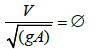 (3)
(3)
In which: V (ft/y)=migration rate=dM/dt; g (ft/s)=acceleration of gravity; A (ft)=meander amplitude; S=slope; f (s)=f (s)=function of s.
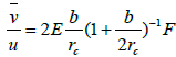
4. Odgaard [22] solved constitutive equations by assuming that the rate of bank erosion is proportional to the difference between the near-bank depth-averaged mean velocity and the reach-averaged mean velocity at bank full discharge. The resulted equation indicates that the erosion rate is correlated with channel characteristics such as width, depth, curvature, bend angle of channel centerline, channel slope, friction factor, and degree of vegetation on the banks. The predictions using this equation agreed well with data measured by using historical records (air photos, maps, and stream flow records), field measurements, and soil analysis in East Nishnabotna River and Des Moines River in Iowa.
 (4)
(4)
 (5)
(5)
 (6)
(6)
 (7)
(7)
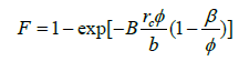
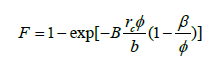
Where,
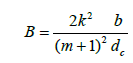
 (m/year): the average rate of erosion; u (m/s): reach-average mean velocity; e: erosion constant; α: 1.27; θ: Shields’ parameter, 0.06; m: friction parameter; k: Karman’s constant, 0.40; F: particle Froude number; b (m): bank-full width of channel; rc (m): radius of curvature. φ: bend angle; β: angle from cross over to first outer bank erosion occurrence; dc: centerline flow depth. In the calculations, two variables were assumed for this study: the friction factor (m) was taken as 3 and particle Froude number ( FDC) [22]. In addition, the erosion constant was taken as e=6.4 × 10⁻⁷ and e=4.4 × 10⁻⁷ for the case of light or no vegetation and dense vegetation on outer bank, respectively. This method considers flow (u), soils (e), and geometry (b/r-7). If the right erosion constant was picked, the predicted migration rate is close to the measured one. Although soil erosion is a fundamental property of soils, it was treated as an empirical coefficient here. A value can be chosen based on existing records. But there is no guarantee that the value will work for a true prediction case. The erosion resistance of soils can be obtained by using EFA (Erosion Function Apparatus) to test the erosion function of soil [23]. It is worthwhile to study how to replace erosion constant e here with EFA function. The above method was a simplified version of a more complex solution developed by the same author Odgaard [22]. A modified version came out soon. However, unfortunately the answer was very sensitive to some parameters.
Additionally, there are also a number of other researches, which mention to the prediction of meander migration by computer programs and be also widely cited in literatures as Wang [24], Thien [11-14,16].
Nonetheless, above methods are simple determine the qualitatively rather than quantitatively. As well as they mention incompletely to the parameters of river hydro-morphology, lead to the great difference existence between calculating results and field measuring for Vietnam meander rivers in generally and the mid-central part of Vietnam in particularly, whose riverbanks are structured by the organic mud, cohesive soils, granular soils and gravels. Meanwhile, calculating the lateral erosion rate by the method of Hickins and Nanson [25] in some Vietnam Rivers are reliable and consistent with the investigated data [5,7,8,12-14]. Therefore, we utilize the above semi-empirical method to assess the lateral eroded rate in the region of interest, to orient for reasonable prevention science and technology solutions to mitigate the serious damages by the process of erosion caused, attained to the suitable exploitation and geological environmental protection of the territory. Simultaneously, determine the erosion belts for the planning and development of industrial and residential zones.
Base documents
To implement calculating and predicting the rate of lateral erosion of above rivers, the authors use data and documents as below [7,11,12-15] (Figures 2 and 3):

Figure 2: Measure hydro-morphological characteristics of Vietnam mid-central rivers (a) The bottom sediment sampling, (b) Granular composition test, (c,d) Measure hydrological cross section.

Figure 3: Investigate the actuality of erosion and erosion preventive measures, mitigation of damages for Vietnam mid-central rivers (a) Riverbank erosion investigation, (b) Sediment sampling at riverbanks, (c,d) Investigate erosion prevention works
1. The geological and topographical features, the erosion resistance (Monogram of Hickins and Nanson [25]), structure and lithological composition of rocks and soils created the riverbanks, riverbank elevation at hydro-morphological cross-sections, the width of flows or channels, bend radius of meandering bank and so on.
2. The hydrological characteristics at 15 cross sections in Gianh River, 12 sections in Nhat Le River, 8 sections in Thach Han River, 5 sections in Huong River, 9 sections in Thu Bon River, 6 sections in Tra Khuc River and 5 sections Ba River was calculated as bed forming discharge (Qcf), the average depth of flood flow, the hydraulic slope of flow (Jcf) in the investigated rivers (Figures 4-8).


Figure 5: Actual state map of erosion in the mid-downstream of Nhat Le River (Quang Binh province), Thach Han River (Quang Tri province), Huong River (Thua Thien Hue province) and the positions of calculated cross-sections.

Figure 6: Actual state map of erosion in the mid-downstream of Thu Bon River (Quang Nam province) and the positions of calculated cross-sections.


The results of state investigation of lateral erosion after flood season in period 2012-2015 combine with state report of riverbank and estuary erosion from Storm and Flood Control and Dyke Management of provinces in the mid-central part of Vietnam.
Research Methods
Nanson and Hickin [26] described that the ratio of radius of curvature of a bend (R) to channel width (W) influences the lateral migration rate of a meandering river. The relationship between channel migration rate (MR) and the ratio of radius of curvature to channel width for the Beatton River, Canada and other rivers indicate that the normalized migration rate (MR/W) is highest when the ratio of radius of curvature to channel width (Rc/W) is about 3. Their data confirm, approximately, the following relations:
MR=0.2 (Rc/W) for (Rc/W)<3 (8)
MR=2.0 (Rc/W)-1 for (Rc/W) ≥ 31 (9)
Where, MR (m/year): Mean Erosion Rate; W (m): Channel Width; Rc (m): Radius of Curvature
This relationship between migration rate and geometry was widely cited in literature. But the scatter in data doesn’t necessarily lead to the relationship the authors proposed. With the same data, different persons may come up with completely different relationships. Geometry is only one factor affecting meander migration. Other important factors such as velocity and soil properties were ignored in the authors’ conclusion. This study described the relation between migration rate and geometry qualitatively rather than quantitatively. Thus, these authors continued to complete above semi-empirical equation in research as specified [7]:
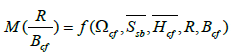
Based on the empirical research for the rate of lateral erosion in 189 riverbanks, it created from clayey and sandy soils of 21 rivers in West Canada. Later, these authors established the equilibrium equation between rate of lateral erosion M (R/Bcf) with hydrodynamic pressure of flow, eroded resistance of rocks and soils at the riverbank; and the features of hydrology - morphology of flow. Finally, the empirical expression is a multivariate functions as follows.
 (10)
(10)
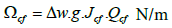
Where, Ωcf (N/m): total power of flood flows through 1 meter wide;  the average coefficient of erosion resistance of rocks and soils at riverbanks;
 (m): the average depth of flow corresponding to bed forming discharge (Qcf) at calculated hydrological sections; R(m): radius of curvature; Bcf(m): flow or channel width of calculated hydrological section corresponding to bed forming discharge.
By dimensional analysis of variables and streamlining function under really situation, the authors gave the formulas to determine the rate of lateral erosion as below:
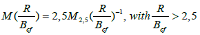 (11a)
(11a)
Or 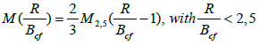 (11b)
(11b)
Where: 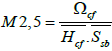 (12)
(12)
 (13)
(13)
Δw: Specific Gravity of Water (1000 kg/m3);
g: Acceleration of Gravity (9.81 m/s2);
Jcf: Hydraulic Slope along Flood Flow;
Qcf: Bed-Forming Discharge (m3/s).
Research Results and Discussion
In order to calculate rate of lateral erosion M (R/Bcf) in middownstream of investigated rivers, we implement to determine hydro-morphology characteristics at the cross-sections. In which, the bed forming discharge (Qcf, m3/s) was identified by various following methods [24,27]:
As for river sections without hydrological station level 1 (monitor water levels, flows, sediment loads), we applied flood flow method when floods spread out the riverbank. Gianh River is an example in flood season in October, 2010 with Qcf (1063 m3/s) was identified at cross-section Gi15 (Kim Hoa commune); Also for Nhat Le River (in flood season September, 1968) with Qcf (2110 m3/s) determined at cross-section NL12 [14]; As for Thach Han River, Qcf (1750 m3/s) was identified from monitoring data in flood season October, 2010 at cross-section TH08 (Tram dam) [3]. By Huong River and Thu Bon River, Qcf was identified from monitoring data of floods in October- November, 2000 at river cross-sections as H05 (Kim Long, 2550 m3/s), TB09 (Giao Thuy, 4350 m3/s), TB03 (Cau Lau, 3250 m3/s) [1,7,10-12]. In addition, the paper also utilizes data series in period 1979 - 2008 at Son Giang hydrological measuring station for Tra Khuc River and Cung Son station for Ba River, in combination with frequency method to guarantee about 5 percent accurate for Qcf (1400 m3/s) determination at river cross-section TK06 (downstream of Thach Nham dam) and the method of Makaveev to identify Qcf (2100 m3/s) at river cross-section B05 (Dong Cam dam) [13]. The calculated results of lateral erosion rate at cross- sections are shown in Tables 1-3 and Figure 9 as following:
| Rivers | Cross-sections of rivers | Bcf (m) |
 (m) |
R (m) |
Jcf (x10-4) |
Qcf (m3/s) |
 (N/m) |
 (N/m2) |
M2.5 |  |
 |
|---|---|---|---|---|---|---|---|---|---|---|---|
| Gianh River | Gi15 | 87 | 5.56 | 382 | 7.94 | 1063 | 8280 | 340 | 4.38 | 4.39 | 2.49 |
| Gi14 | 99 | 6.60 | 604 | 6.80 | 1093 | 7291 | 314 | 3.52 | 6.10 | 1.44 | |
| Gi13 | 103 | 6.51 | 943 | 6.03 | 1105 | 6537 | 256 | 3.92 | 9.15 | 1.07 | |
| Gi12 | 146 | 6.02 | 313 | 4.82 | 1146 | 5419 | 550 | 1.64 | 2.14 | 1.25 | |
| Gi11 | 198 | 5.40 | 1400 | 4.21 | 1196 | 4939 | 498 | 1.84 | 7.07 | 0.65 | |
| Gi10 | 248 | 7.12 | 1380 | 3.68 | 1690 | 6101 | 246 | 3.48 | 5.56 | 1.56 | |
| Gi09 | 375 | 6.18 | 1994 | 3.48 | 1700 | 5804 | 138 | 6.80 | 5.32 | 3.19 | |
| Gi08 | 325 | 6.07 | 1970 | 3.31 | 1700 | 5520 | 115 | 7.90 | 6.06 | 3.26 | |
| Gi07 | 300 | 3.88 | 1682 | 2.98 | 1700 | 4970 | 88 | 14.55 | 5.61 | 6.48 | |
| Gi06 | 450 | 5.95 | 1950 | 2.50 | 1700 | 4169 | 67 | 10.46 | 4.33 | 6.04 | |
| Gi05 | 645 | 5.50 | 2750 | 2.15 | 1700 | 3585 | 60 | 10.86 | 4.26 | 6.37 | |
| Gi04 | 500 | 5.24 | 4050 | 1.96 | 1300 | 2500 | 45 | 10.60 | 8.10 | 3.26 | |
| Gi03 | 450 | 4.92 | 4475 | 1.79 | 1300 | 2283 | 40 | 11.60 | 9.94 | 2.93 | |
| Gi02 | 497 | 8.86 | 4400 | 1.24 | 1310 | 1594 | 37 | 4.86 | 8.85 | 1.37 | |
| Gi01 | 399 | 8.90 | 4050 | 1.02 | 1310 | 1311 | 35 | 4.20 | 1015 | 1.03 | |
| Nhat Le River | NL12 | 90 | 7.38 | 324 | 6.68 | 2110 | 13826 | 510 | 3.67 | 3.6 | 2.54 |
| NL11 | 137 | 6.32 | 287 | 6.03 | 2110 | 12481 | 590 | 3.35 | 2.09 | 2.43 | |
| NL10 | 145 | 7.68 | 332 | 5.80 | 2120 | 12062 | 420 | 3.74 | 2.29 | 3.22 | |
| NL09 | 141 | 7.24 | 943 | 4.21 | 2130 | 8796 | 256 | 4.75 | 6.69 | 1.77 | |
| NL08 | 85 | 4.78 | 472 | 3.68 | 1410 | 5090 | 327 | 3.26 | 5.55 | 1.47 | |
| NL07 | 51 | 3.25 | 313 | 3.41 | 1410 | 5073 | 550 | 2.84 | 6.13 | 1.15 | |
| NL06 | 231 | 6.07 | 1380 | 2.75 | 1410 | 4717 | 210 | 3.70 | 5.97 | 1.55 | |
| NL05 | 426 | 5.85 | 1940 | 0.196 | 4020 | 773 | 115 | 1.15 | 4.55 | 0.63 | |
| NL04 | 674 | 4.87 | 3100 | 0.185 | 2010 | 364 | 75 | 1.00 | 4.60 | 0.54 | |
| NL03 | 752 | 4.45 | 2742 | 0.172 | 2010 | 339 | 60 | 1.27 | 3.65 | 0.87 | |
| NL02 | 556 | 4.64 | 4400 | 0.137 | 2020 | 271 | 37 | 1.58 | 7.91 | 0.50 | |
| NL01 | 364 | 8.81 | 4050 | 0.111 | 2020 | 219 | 35 | 0.71 | 11.13 | 0.16 | |
| Thach Han River | TH08 | 130 | 5.37 | 1942 | 6.68 | 1750 | 11777 | 230 | 9.54 | 14.94 | 1.60 |
| TH07 | 249 | 4.54 | 1380 | 6.42 | 1750 | 11022 | 195 | 12.45 | 5.54 | 5.62 | |
| TH06 | 236 | 6.70 | 1625 | 5.57 | 1680 | 9180 | 150 | 9.13 | 6.89 | 3.32 | |
| TH05 | 145 | 6.75 | 1760 | 4.24 | 1680 | 6988 | 115 | 9.00 | 12.14 | 1.85 | |
| TH04 | 669 | 5.41 | 2750 | 3.71 | 2680 | 9754 | 82 | 21.99 | 4.11 | 13.37 | |
| TH03 | 425 | 5.76 | 3652 | 3.45 | 2680 | 9070 | 66 | 23.86 | 8.59 | 6.94 | |
| TH02 | 1209 | 5.02 | 4220 | 2.77 | 1350 | 3668 | 52 | 14.05 | 3.49 | 10.07 | |
| TH01 | 348 | 9.99 | 4050 | 1.96 | 1350 | 2596 | 43 | 6.04 | 11.64 | 1.30 | |
| Huong River | H05 | 173 | 7.20 | 2050 | 6.30 | 2550 | 15760 | 150 | 14.59 | 11.85 | 3.08 |
| H04 | 206 | 7.22 | 1425 | 4.23 | 2550 | 10582 | 105 | 13.96 | 6.92 | 5.04 | |
| H03 | 237 | 6.00 | 1057 | 2.61 | 2550 | 6529 | 93 | 11.70 | 4.46 | 6.56 | |
| H02 | 170 | 8.50 | 3580 | 1.57 | 2550 | 3927 | 67 | 6.90 | 21.06 | 0.82 | |
| H01 | 371 | 3.74 | 3235 | 1.11 | 2550 | 2777 | 52 | 14.28 | 8.72 | 4.09 | |
| Thu Bon River | TB09 | 395 | 5.85 | 1980 | 1.53 | 4350 | 6529 | 200 | 5.58 | 5.01 | 2.78 |
| TB08 | 280 | 4.91 | 1453 | 2.67 | 4350 | 11394 | 187 | 12.41 | 5.19 | 5.98 | |
| TB07 | 295 | 6.29 | 1400 | 2.55 | 4350 | 10882 | 155 | 11.16 | 4.75 | 5.88 | |
| TB06 | 390 | 5.37 | 1375 | 1.50 | 4350 | 6401 | 110 | 10.84 | 3.53 | 7.68 | |
| TB05 | 275 | 5.90 | 2557 | 2.34 | 4350 | 9986 | 100 | 16.92 | 9.30 | 4.55 | |
| TB04 | 270 | 5.66 | 1100 | 1.82 | 4350 | 7767 | 95 | 14.44 | 4.07 | 8.86 | |
| TB03 | 350 | 5.45 | 1870 | 1.67 | 3250 | 5324 | 62 | 15.76 | 5.34 | 7.37 | |
| TB02 | 747 | 8.80 | 2750 | 1.45 | 3250 | 4623 | 59 | 8.90 | 3.68 | 6.05 | |
| TB01 | 365 | 7.55 | 3540 | 1.07 | 3250 | 3411 | 43 | 10.51 | 9.70 | 2.71 | |
| TraKhuc River | TK06 | 500 | 3.38 | 2250 | 1.34 | 1400 | 1840 | 91 | 5.98 | 4.50 | 3.32 |
| TK05 | 340 | 4.41 | 2890 | 1.98 | 1400 | 2719 | 68 | 9.07 | 8.50 | 2.67 | |
| TK04 | 640 | 1.96 | 2756 | 1.03 | 1400 | 1415 | 52 | 13.88 | 4.31 | 8.06 | |
| TK03 | 570 | 2.23 | 2540 | 0.53 | 1400 | 714 | 62 | 4.93 | 4.46 | 2.76 | |
| TK02 | 870 | 1.99 | 3600 | 0.49 | 1400 | 673 | 66 | 5.93 | 4.14 | 3.58 | |
| TK01 | 1550 | 2.85 | 3540 | 0.34 | 1400 | 467 | 60 | 3.81 | 2.28 | 4.17 | |
| Ba River | B05 | 230 | 17.23 | 1760 | 5.84 | 2100 | 12031 | 164 | 4.26 | 7.65 | 1.39 |
| B04 | 250 | 11.10 | 2750 | 4.75 | 2100 | 9785 | 112 | 7.87 | 11.00 | 1.79 | |
| B03 | 400 | 6.94 | 3652 | 4.04 | 2100 | 8323 | 85 | 14.11 | 9.13 | 3.86 | |
| B02 | 550 | 4.57 | 4220 | 3.22 | 2100 | 6634 | 57 | 25.47 | 7.67 | 8.30 | |
| B01 | 230 | 17.23 | 4050 | 1.27 | 2100 | 2616 | 43 | 3.53 | 17.61 | 0.50 |
Table 1: Results of determining rate of lateral erosion M (R/Bcf) in mid-downstream of research rivers.
| Rivers | Lateral erosion rate (m/y) | ||
|---|---|---|---|
| Min | Max | Mean | |
| Gianh | 0.65 | 6.48 | 2.85 |
| Nhat Le | 0.16 | 3.22 | 1.35 |
| Thach Han | 1.30 | 13.37 | 5.29 |
| Huong | 0.82 | 6.56 | 2.66 |
| Thu Bon | 2.71 | 8.86 | 5.62 |
| TraKhuc | 2.67 | 8.06 | 3.30 |
| Ba | 0.50 | 8.30 | 2.35 |
Table 2: The minimum, maximum and mean of lateral erosion rate in the investigated rivers (statistical analysis values).
| Rivers | The mean of lateral erosion rate (m/y) | |||
|---|---|---|---|---|
| Weak <2 m/y |
Moderate 2-5 m/y |
Strong 5-10 m/y |
Very strong >10 m/y |
|
| Gianh | 1.20 | 3.03 | 6.30 | - |
| Nhat Le | 0.96 | 2.73 | - | - |
| Thach Han | 1.58 | 3.32 | 6.28 | 11.72 |
| Huong | 0.82 | 3.59 | 5.80 | - |
| Thu Bon | - | 3.35 | 6.97 | - |
| TraKhuc | - | 3.30 | 8.06 | - |
| Ba | 1.23 | 3.86 | 8.30 | - |
Table 3: The mean of lateral erosion rate at each investigated river section.

Figure 9: Diagram of lateral erosion rate at calculated cross-sections in the mid-central rivers of Vietnam.
1. Through Tables 1 and 2, they indicates that the erosion rate values of the mid-central rivers have no significant differences among them and occurs popularly with rate from moderate to strong. Specifically, the lateral migration occurs with moderate rate for Gianh River (2.85 m/y), Huong River (2.66 m/y), Tra Khuc River (3.30 m/y) and Ba River (2.35 m/y). Erosion activity of Thach Han River and Thu Bon River occurs with strong rate by 5.29 m/y and 5.62 m/y, respectively. In Nhat Le River, lateral erosion rate gets the lowest only 1.35 m/y. In addition, the maximum erosion rate of investigated rivers reaches 6.48-8.86 m/y even 13.37 (Thach Han), except Nhat Le River (3.32m/y). The minimum erosion rate raises from 0.16-1.3 m/y to 2.67-2.71 m/y for all of rives. These results are suitable for our field investigation and published researches in period 2012-2015 [13-15] (Figures 4-8 and Table 4) as well as the researches of other authors [1,28].
| Order | Rivers | River length (L, km) |
Cofficient of erosion (Ke=L/åLi, %) |
Erosion rate (Ve ,m/s) |
Rating motiation of river erosion |
|---|---|---|---|---|---|
| 1 | Gianh | 80 | 16.0 | 2-5 | Medium, harmful and serious |
| 2 | Nhat Le | 57 | 9.7 | 1-2 | Weak, less harmful, less serious |
| 3 | Thach Han | 27 | 23.6 | 5-10 | Strong, very harmful and very serious |
| 4 | Huong | 40 | 18.0 | 2-5 | Medium, harmful and serious |
| 5 | Thu Bon | 55 | 26.9 | 5-10 | Strong, very harmful and very serious |
| 6 | Tra Khuc | 40 | 27.9 | 2-5 | Medium, harmful and serious |
| 7 | Ba | 50 | 25,6 | 2-5 | Medium, harmful and serious |
Table 4: The assessment of erosion motivation in the mid-central rivers of Vietnam [13,15] (Li: Total length of the erosion sections).
2. As shown in Tables 1 and 3 and Figures 4-9, the lateral migration activity of investigated rivers is strongly differentiated by space-time and depend completely on the morphological characteristics of river channel, soil composition and ground structure of riverbanks as well as hydrology - hydraulic regime of each river, especially river sections.
In which: Regarding to Gianh River, lateral erosion occurs with weak rate (0,65-1,56 m/y) in the middle stream (from Gi10-Gi14) and nearing estuary (from Gi01-Gi02) with the mean of 1.20 m/y. As for downstream of river (from Gi03-Gi09), this erosion process alternated in rate range from moderate (2,93-3,26 m/y, 3.03 m/y in mean) to strong (6,04-6,48 m/year, 6.30 m/y in mean). Although the high curvature ratio with value from 1,31 to 1,38, the riverbanks is structured from hard rocks get high erosion resistance lead to be less effected by lateral erosion. Specifically, the ground structure of riverbanks are mainly cohesive soils, granular soils with medium erosion resistance and be effected by high flood flows so that the erosion process occurred with rate from weak to moderate. The lateral erosion in Nhat Le River appeared with weak rate (0,16-1,77 m/y, 0.96 m/y in mean) with moving tendency commonly to the downstream the rate of lateral erosion decreased (at cross-section NL01-NL09). Specially in the middle stream (NL10-NL12), the riverbanks were created from hard rocks in mixture of clayey soils had relatively high erosion resistance, but they got totally effects of bottom forming flow lead to reaching level of lateral erosion moderate (2,43-3,22 m/year, 2.73 m/y in mean) in middle stream [5,23].
Due to meandering river channels and numerous anabranches, the flow velocity of Thach Han River changed complicated. The lateral erosion rate value has the alternation from weak (1,30-1,60 m/year, 1.58 m/y in mean) in the middle stream (at cross-section TH08) and estuary (TH01) to moderate (3,22 m/year - at cross-section TH06), strong (5,62-6,94 m/year, 6.28 m/y in mean; TH03, TH07) and very strong (10,07-13-37 m/year, 11.72 m/y in mean; TH02, TH04) in the downstream [3].
The lateral erosion rate of the Huong River has the partly change from the upper to downstream with specifically the moderate rate occurs at river cross-section H05 and H01 by 3,08-4,09 m/year and 3.59 m/year in mean. As for the middle stream, due to the curved river sections, the erosion occurs strongly with eroded values 5.04- 6.56 m/year and mean value is 5.80 m/year at cross-section H04-H03. Especially, in the downstream, the erosion happens with the lowest rate by 0.82 m/year at H02 [7].
The lateral erosion in mid-downstream of Thu Bon and Tra Khuc Rivers has features similar to alternative rates from moderate (2,67-4,55 m/year) to strong (5,88-8,86 m/year). In which, the lateral erosion occurs with moderate rate (Cross-sections TB09, TB01 in Thu Bon River and TK06, TK01, TK02, TK03 in Tra Khuc River) in the middle stream and nearing estuary parts. Because of curved river, appearance of large river sandbars, the flood flows are prevented. Therefore, the lateral erosion gets the alternative rate from moderate to strong and depends on hydrology - morphology characteristics of each river sections [11,15].
The erosion process of Ba Riverbank occurs with ascending rate from weak (1,39-1,79m/year, 1, 23 m/y in mean; B04-B05), moderate (3,86 m/year, B03) to strong (8,30 m/year, B02) in the way to downstream. At nearing estuary, due to low riverbanks, the flood spread out link to real bed forming discharge decline to 50% and weak lateral erosion [13,14].
Conclusion
From mentioned research results, we conclude and propose as following:
1. In whole research area, the rate of lateral migration rate alternates typical from moderate (Gianh River, Huong River, Tra Khuc River, Ba River) to strong (Thach Han River, Thu Bon River) with commonly tendency on the way to the downstream lateral erosion has decrease. In various rivers, as for Nhat Le River occurs weak lateral erosion.
2. The lateral migration activity of investigated rivers is strongly differentiated by space-time and depend completely on the morphological characteristics of river channel, soil composition and ground structure of riverbanks as well as hydrology - hydraulic regime of each river, especially river sections.
3. The river channels of the mid - downstream in the research area get high slope, short, distributing nearly moderate mountains to follow orientation from the Northwest to Southeast. These are suitable conditions to hit from storm wind, moisture, which turned into the high rainfall zones, abundant water sources supply for the formation of flash floods, increasing intensity and scale of lateral erosion process in the mid-central rivers of Viet Nam.
4. The organic mud, cohesive soils, granular soils and gravels mainly structure the riverbanks. So, under the impact of bed forming discharge and economic - engineering activities (hydropower plants, bridges, roads, deforestation, sand - gravel exploitation), these river channels will still change in the flood season in next years.
5. The obtained outcomes of erosion rate calculating are quite consistent with our survey data and a number of other researches, which were cited in literatures. Especially, the rate values of lateral erosion at curved river sections get the highly reliability so that it is necessary to use for predicting the lateral migration for meandering rivers in the central part in particularly and for Vietnam in general.
References
- Thien DQ (2001) The rules of erosion-accumulation activities in large rivers of Vietnam central part. Scientific Articles of Hanoi University of Mining and Geology 36: 97-102.
- Thien DQ (2014) Research on the erosion-accumulation processes of rivers in mid-central part of Vietnam and propose suitable preventive solutions. Ministry-Level Research Project, code: B2011-DHH02, Hue University of Sciences, Vietnam.
- Anh TN (2010) Research on erosion accumulation in Thach Han River system. Project of disaster risk management, Hanoi National University of Science, Vietnam.
- Dan NL (2007) Investigation, research of the accumulation activity at Nhat Le estuary and preventive measures. Vietnam Academic of Science and Technology.
- Tho NV, Thanh N (2001) Research, predicts and prevent to the erosion of riversides in the central part of Viet Nam. National-level Research Project.
- Thien DQ (2002) Research on the erosion of Huong riverbank in section from Tuan to BaoVinh town and propose preventive measures. Master Thesis of Engineering, University of Mining and Geology, Vietnam.
- Thien DQ, Tuyen TH (2002)The relation between geological structure and erosion - accumulation activities in Huong River downstream. Scientific Journal of Hue University, Issue: Natural Sciences 11: 51-55.
- Thien DQ, Thanh N, Toan DM(2008)The prediction research methods of erosion - accumulation process in Thu Bon River channel from GiaoThuy to Cua Dai. National Conference on Geological Disasters and Preventive Methods, Vietnam 230-243.
- Thien DQ, Do HNT (2008) The method of hydro-morphology in research and predicting erosion - accumulation processes in Huong River channel. The Scientific Conference on the 60th Celebration of Vietnam Geological Discipline, pp: 409-413.
- Thien DQ (2008) Features of geological environment in the downstream of Thu Bon River and their changes from economy-engineering activities.Doctoral Thesis of Geology, University of Mining and Geology, Vietnam.
- Thien DQ (2010) Research, predict the changes of Thu Bon River channel in the downstream under the impacts of hydropower works in upstream. Ministry - level Research Project, Vietnam. Code: B2009-DHH01-76.
- Thien DQ, Nhan TT, Thanh N (2012) The implicit danger of system of Vu Gia - Thu Bon stepping hydropower works for accumulation activity at lower section. Proceedings of the International Conference on Green Technology and Sustainable Development, Vietnam, pp: 25-34.
- Thien DQ, Do HNT (2016) Assess and predict the riverbank erosion process in QuangBinh province: Apply for Gianh and Nhat Le River. Third International Conference Vietgeo 2016, Geological and Geotechnical Engineering in Response to Climate Change and Sustainable Development of Infrastructure, pp: 294-303.
- Thien DQ, Nhan TT, Nhan NTT, Dennis G, Do HNT, et al. (2016) Assess the motive of erosion process along main river channels in the mid - central part of Vietnam.The 2nd National Conference on Transport Infrastructure with Sustainable Development, Construction House, Vietnam 126: 317-326.
- Van TT(2002) Assess the geo-hazards in the coastal provinces of central part of Vietnam from QuangBinh to Phu Yen - Actual state, causes, prediction and propose the preventive measures, mitigation of damages. Vietnam Institute of Geosciences and Mineral Resources.
- Yem NT(2001) Investigation, assessing the erosion-accumulation disasters in the coastal region of QuangNgai province and proposing preventive measures, mitigation of disasters, contribute to the promotion of the socio-economic development plan with sustainable environment. Vietnam Academic of Science and Technology.
- Duc DM (2010) Erosion features of cau riverbank in BacKan province, Vietnam. Technical Journal of Vietnam 5: 41-47.
- Toan DT, Duc DM (2011) Research on predictive models of riverbank erosion (A study case of Cau River in Cho Moi, BacKan province, Viet Nam). Technical Journal of Vietnam 2: 17-23.
- Brice JC (1982) Stream channel stability assessment. U.S. Federal Highway Administration, Environmental Division and Geological Survey (U.S.). Water Resources Division, USA.
- Hooke JM (1980) Magnitude and distribution of rates of river bank erosion. Earth Surface Processes 5: 143-157.
- Keady DM, Priest MS (1977) The downstream migration rate of river meandering patterns. Meeting 12th Mississippi Water Resources Conference, Jackson, Mississippi.
- Odgaard AJ (1986) Meander flow model. I: Development. Journal of Hydraulic Engineering, ASCE 112: 1117-1136.
- Briaud JL, Chen HC, Chang KA, Chung YA, Park N, et al. (2007) Establish guidance for soils properties-based prediction of meander migration rate. Department of Civil Engineering, Texas A&M University.
- Wei Wang (2006) Hydrograph based prediction of meander migration. Doctoral Thesis Graduate Studies of Texas A&M University.
- Hickins EJ, Nanson GC (1984) Lateral migration rates of river bends. Journal of Hydraulic Engineering,American Society of Civil Engineers 110: 1557-1567.
- Nanson GC, Hickin EJ (1983) Channel migration and incision on the Beatton River. Journal Hydraulic Engineering, ASCE 109: 327-337.
- Belletti B,Rinaldi M, Buijse AD,Gurnell AM (2015) A review of assessment methods for river hydro-morphology. Environmental Earth Sciences 73: 2079-2100.
- Wang ZY, Lee JHW,Melching CS (2015) River dynamics and integrated river management. Tsinghua University Press, Beijing.

