Research Article, Hydrogeol Hydrol Eng Vol: 10 Issue: 3
Spatial Variability of Runoff Generation in a Hyper Arid Area
Aaron Yair1*, Eran Meiri2 and Hanan Ginat3
1 Department of Geography, Hebrew University of Jerusalem, Jerusalem, Israel
2 Department of Geology, Dead Sea and Arava Science Center, Arava, Israel
*Corresponding Author: Aaron Yair Department of Geography, Hebrew University of Jerusalem, Israel Tel: 972548820015 E-mail: aaron.yair@mail.huji.ac.il
Received date: February 23, 2021; Accepted date: March 10, 2021; Published date: March 18, 2021
Citation: Yair A, Meiri E, Ginat H (2021) Spatial Variability of Runoff Generation in a Hyper Arid Area. J Hydrogeol Hydrol Eng 10:3.
Keywords: Vadose Zone Hydrology Hydrology Modelling Ecohydrology Hydrochemistry Hydroinformatics
Abstract
Overland flow is usually regarded as an important contributor to channel flow. This approach is certainly valid in arid watersheds, where base flow is irrelevant, especially in small watersheds, where non-climatic factors such as lithology, topography, and local surface properties can exert a strong influence on overland flow generation. Understanding overland flow generation in dry land areas is therefore especially important, as rainfall thresholds for stream flow generation are highly dependent on the frequency and magnitude of overland flow generation. A relatively large literature is available for semi-arid areas. In some of these studies it is clearly stated that despite the lower average annual rain amount, the frequency and magnitude of channel flow is higher in the drier than in the semi-arid, wetter areas. This is attributed to a more extensive soil and vegetation cover in the wetter areas. Nevertheless, our knowledge on the complex factors that control overland flow generation, the main contributor to channel flow in extremely arid areas, (below 50 mm average annual rainfall) are very rare. The main objective of the present work is to obtain accurate data on runoff generation, in an extremely arid area (~28 mm average annual rainfall), under natural rainfall conditions in a variety of geological formations and surface properties. The study was based on a couple of small runoff plots (~3 m2) in each of the following lithology’s: Limestone, Granite, Sandstone and Siltstone. One plot represents a rocky surface and the second a colluvial surface. The study lasted two consecutive years. Data obtained showed that the frequency and magnitude of runoff generation, in each of the lithologies, were always higher over the rocky plots than over the colluvial plots. However, runoff generation was not uniform in the rocky, and in the colluvial plots. This is due to the local surface characteristics of each plot, such as stoniness and surface roughness. Data obtained bring us back to two important issues in geomorphology. The first is the possibility to extrapolate data from one area to another area with the same rainfall regime. The second issue is the relative geomorphic importance of frequent rain events versus rare geomorphic events.
Keywords
Lithology; Dry land; Runoff generation; Topography
Introduction
Global climate change is a frequently addressed issue. This issue is critical in dry land areas, regarded as highly sensitive to climate change. The relationships between average annual rainfall and environmental variables has attracted the attention of many scientists. Climatologists use aridity indices to express the relationships between climatic and environmental variables. These indices, based on purely climatic variables, imply that the acuteness of aridity is inversely related to annual precipitation, air temperature, radiation, etc. The validity of the global climatic models is questionable at smaller regional scales, especially in dry land areas, where non-climatic factors such as lithology, topography, and surface properties can exert a strong influence on water resources. In addition, the global models, based on the average annual rainfall, disregard the characteristics of the local rainfall regime, such as the duration of the effective individual rain-showers during a rainstorm [1]. Overland flow is usually regarded as an important contributor to channel flow. This approach is certainly applicable to arid watersheds, where base flow is irrelevant, particularly in small watersheds. Understanding overland flow generation in dry land areas is therefore very important, as rainfall thresholds for stream flow generation are highly dependent on the frequency and magnitude of overland flow generation. A relatively large literature is available for semi-arid areas [2-8]. However, in some of these studies, it is clearly stated that despite the lower average annual rain amount, the frequency and magnitude of channel flow is higher in the drier than in the semi-arid, wetter areas. This is attributed to a more extensive soil and vegetation cover in the wetter areas. Nevertheless, our knowledge of the complex factors that control overland flow generation, the main contributor to channel flow in extremely arid areas (below 50 mm average annual rainfall) is very rare [9] have studied overland flow generation in an extremely arid area within the Yael Watershed Research Station, located few kilometers away from the present research sites. The study was based on overland flow generation under natural rainfall conditions, in three runoff plots extending over 40 m-60 m. The lithology of the plots is not the same.
Amphibolite is the dominant formation with acid dykes. In addition, outcrops of gneiss are quite extensive. The amphibolite is the least resistant rock. It weathers into coarse sand. The dykes, which are more resistant, decompose into coarse gravels, and the gneiss into very small gravels. In all plots the upper gravelly layer is underlain by a mixture of sand silt and clay. The particle size composition of the lower layer is quite uniform in all plots. However, the upper layer of the plots is not uniform. The plot with the dyke is composed of bigger gravels than in the adjoining plots. Data were collected in a single year. Annual rainfall amounted at 28 mm, in 10 rainy days. Daily rain amount varied in the range of 0.22 mm-7.05 mm, with low rain intensities, below 0.45 mm/3 minutes, except for one rain event with 1.5 mm/3 minutes. Five overland flow events were recorded; with daily rain amounts exceeding 3 mm. Runoff coefficients were not uniform. Overland flow generation was three times higher in the plot where a dyke is exposed. As indicated earlier, the dyke weathers into much coarser gravels and cobbles than the amphibolite and the gneiss.
Runoff coefficients varied in the range of 0.2%-5% in the plots with the low runoff, while they varied in the wide range of 1.7%-15% in the plot with the dyke. The explanation proposed was that runoff starts almost immediately over the large gravels and cobbles, due to their negligible infiltration rate. Runoff occurs quickly, when runoff amounts delivered by the gravels and cobbles are higher than the infiltration rate of the underlying layer. The process of water concentration is much less efficient in the plots where the surface is composed of very small gravels. Similar results have been reported by Yair and Lavee in a study of overland flow generation over six talus slopes in the north eastern sector of the Sinai Peninsula. Latter study was based on sprinkling experiments that covered a variety of geological formations: Schist, Granite, Coarse sandstone, Limestone and a magmatic dyke. Runoff coefficients obtained in the first run, varied from 0% (coarse sandstone plot) to 40.9% (bare bedrock, granite). The explanation proposed for the differential overland flow generation was that the infiltration rate of the fine-grained lower layer, below the gravelly surface layer, is lower than the rate of water delivery by the cobbles and boulders composing the upper coarse layer. A positive relationship was found between stone size and runoff coefficient.
Aim of Study
According to the said above we contend that local surface properties, and local rainfall characteristics, play a determinant role in overland flow generation in some extremely arid areas, such as the southern Negev desert. The main objective of the present work is to obtain accurate assessment of runoff data concerning the frequency and magnitude of overland flow generation, at a scale of few square meters, under natural rainfall conditions, in a variety of geological formations, and surface properties, in an extremely arid area with an average annual rainfall of ~28 mm.
Description of the Study Area
The extreme southern part of the Negev Desert of Israel, near the Red Sea, offers excellent conditions for the study of the complex hydrological relationships between rainfall and surface properties, in an extremely arid area. The study was conducted in two distinct sites: The Timna site and the Yotvata site. The Timna site is characterized by a great variety of geological formations, covering the long periods from the Precambrian to the Quaternary: granite, sandstone, siltstone, and colluvial deposits [11]. Average annual rainfall is ~ 28 mm. In the last decade annual rainfall varied in the range of 3 mm-61 mm. The highest annual rainfall amount (97 mm) was measured in 1953. The Yotvata site, 23 km north of the Timna site, is represented by a limestone formation, and limestone elastic deposits. The rainy season, in both areas, is confined to the winter months from September to May. The area is subject to two rainfall regimes: The Red Sea regime, and the Mediterranean regime, called Cyprus Low [15,16]. The Red Sea Trough regime is characterized by convective rainstorms, with high rain intensities over a short time, and a limited covered area. The Cyprus Low is characterized by relatively low rain intensities, and low rain mounts in individual intermittent rain-showers [17,18].
Methodology
The study was based on 8 runoff plots selected so as to represent the different lithologies, and surface properties, outcropping in the Timna and Yotvata sites. Low metal walls were inserted into the debris cover, to a depth below the superficial layer of gravels (Figures 1 and 2). The rocky plots were sealed with cement. The area of the small plots varied in the range of 3.4 m2-3.9 m2, according to the local surface conditions. A rainfall collector was installed near the runoff plots [19-25]. The study lasted three consecutive years .
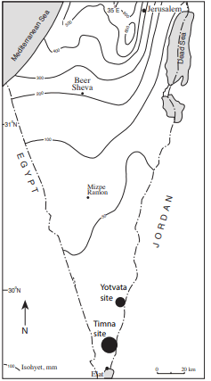
Figure 1: Location map. (â?Â) Timna site; (•) Yotvata site
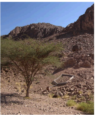
Figure 2: View of a runoff plot.
A clear distinction was made between the rocky plots and the clastic plots (colluvium). The rocky plots are located over steep slope sections, with no soil cover. In some of them gravels are spread over the rocky surface. These plots are considered as relatively impervious, and expected to quickly develop overland flow [26-30]. The clastic plots represent a different environment. Slope angles are lower. These plots are composed of an upper gravelly layer underlain by a layer composed of sand, silt, clay and gravels. The fine-grained material is of Aeolian origin. Attention was given to the cover percent of the gravelly elements within the plots. In addition, the particle size distribution of the fine-grained material, underlying the upper gravelly layer, was determined. Needless to say, this analysis was limited to the clastic plots. Surface properties of the plots are given in Tables 1 and 2.
Yotvata site
The Yotvata site represents a limestone area: The hatsera formation. Two plots have been installed here. One over a rocky area, with gravels spread over most of the plot, and a second plot over the colluvial slope section. Surface properties are provided in Table 1. A rainfall recorder is located at the nearby Yotvata village.
Table 1: Surface properties of the plots at the Yotvata site.
Timna site
The Timna site is characterized by a variety of geological formations: Salomon sandstone formation, Shehoret formation (siltstone), Granite, and colluvial deposits. Six plots were installed in this site. Surface properties of the plots are presented in Table 2. Two plots are located in the granitic area: a rocky plot, and a colluvial plot. Two plots are located in the sandstone area: one represents the rocky Salomon sandstone formation; the second represents the colluvium at the base of this formation. Two plots are located in the Shehoret siltstone formation. One represents a rocky surface and the second a colluvial plot. Rain collectors were placed at the vicinity of the plots.
Table 2: Surface properties of the plots in the Timna site.
Results
Rainfall data
The Yotvata site: 21 rain events have been recorded from January 2013 to October 2015. Rainfall data are presented in Table 3.
Table 3: Rainstorm events recorded at the Yotvata site.
Most rain events are quite limited in their amounts, and rain intensities. On the first year, storm rain amounts varied in the range of 1 mm-10 mm, with relatively low rain intensities, in the range of 6 to 13.2 mm/hr.
The year after, storm rain amounts varied in the range of 1-11.5 mm, again with low rain intensities.
In the last year, six of the 7 rainstorms recorded low storm rain amounts, and low rain intensities (Table 3). An extreme rain event (30 mm) was recorded in 25 October 2015.
Timna site: During the study period 20 storm rain events have been recorded. Rain characteristics are similar to those described for the Yotvata site: Very high frequency of low rainstorm events. 14 rain events are in the range of 1 mm-5 mm; five between 5 mm-9 mm, and one above 9 mm (Table 4).
Table 4: Frequency of storms rain amount (mm) at the Yotvata site.
Rainfall-Runoff Relationships
Yotvata site
Two plots have been established here (Figure 3). All of them are located within the Limestone Hatzera formation. Surface properties are provided in Table 1. Runoff data obtained point to a high spatial variability in the frequency and magnitude of runoff generation (Figure 4). Figure 4A displays runoff generation in the rocky plot. Rainfall threshold for overland flow generation over the rocky area is extremely low: Only ~1mm. Overland flow developed over the rocky area in 17 of the 20 rain events. Runoff coefficients varied in a wide range, reaching up to 70%. There is no clear relationship between storm rain amount and runoff coefficient. Only 8 runoff events were obtained in the colluvial plot, as compared to 17 runoff events in the rocky plot. Rainfall threshold for runoff generation is higher than over the rocky area (~3mm). In addition, runoff coefficients are much lower. The highest runoff coefficient in the colluvial plot was only ~9%.
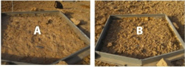
Figure 3: Yotvata site: (A) View of the Rocky plot. (B) View of the Colluvial plot.
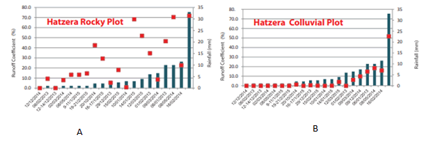
Figure 4: Rainfall-runoff relationships in the limestone area: (A) Rocky area, (B) Colluvial area.
Granite area
Figure 5 shows the view of the runoff plots in the granite area. Figure 6 displays the rainfall-runoff data obtained in the granite area. Figure 6A refers to the rocky plot. Rainfall threshold for runoff generation was ~1mm. The highest runoff coefficient was 50%. Data obtained are lower than on the rocky limestone plot (Figure 4A). Figure 6B refers to the colluvial plot. Rainfall threshold for runoff generation here is 5 mm, and the highest runoff coefficient is ~13%. Sixteen runoff events have been recorded in the rocky plot, and 7 on the colluvial plot. Rainfall thresholds for runoff generation are ~3mm in the rocky plot and 7 mm in the colluvial plot. In both plots the relationships between rainfall and runoff is low, especially in the colluvial plot.
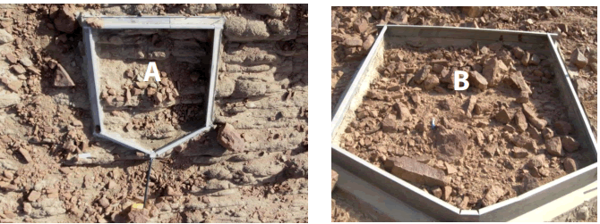
Figure 5: View of the runoff plots in the granite area: (A) Rocky area, (B) Colluvial area.

Figure 6: Rainfall-runoff relationships in the granite area: (A) Rocky area, (B) Colluvial area.
Salomon sandstone area
Figure 7 shows the runoff plots in the Salomon sandstone area. Figure A refers to the rocky area, and Figure B refers to the colluvial area.
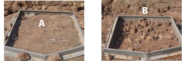
Figure 7: View of the runoff plots in the Salomon sandy area: (A) Rocky plot, (B) Colluvial plot.
Figure 8 refers to the rainfall-runoff data. Data obtained clearly indicate that rainfall threshold for overland flow generation over the rocky area (Figure 8A) is extremely low: 1 mm.
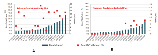
Figure 8: Rainfall-runoff relationships in the Salomon sandy area: (A) Rocky plot, (B) Colluvial plot.
The frequency of overland flow generation, and runoff coefficients, in the sandstone area, are the highest recorded in the frame of the present study. Runoff increases with increasing rain amounts, reaching up to 90%. The frequency and magnitude of overland flow decrease on passing to the colluvial environment (Figure 8B).
Only 9 flows have been recorded in the colluvial plot as compared to 18 flows in the rocky area. Rainfall threshold for runoff generation is 3 mm with no relationship between rainfall and runoff.
Siltstone area
Figure 9 shows the runoff plots in the siltstone area. Figure 9A shows the rocky area and Figure 9B the colluvial area. Figure 10 refers to the rainfall-runoff data. Figure 10 presents the rainfall-runoff data for the plots established in the Siltstone area. The frequency and magnitude of runoff generation are the lowest recorded, when compared to the other rocky plots. The same applies to the colluvial plot.
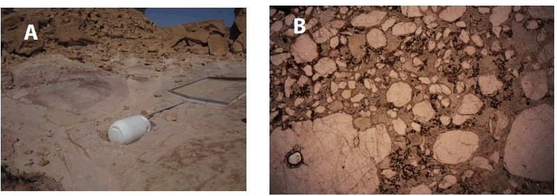
Figure 9: View of the runoff plots in the siltstone area: (A) Rocky plot, (B) Colluvial plot.
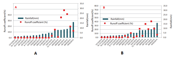
Figure 10: Rainfall-runoff relationships in the siltstone area: (A) Rocky area, (B) Colluvial area.
Rainfall -Runoff relationships at the extreme rainfall event of 25 October 2015.
An extreme rain event was recorded in 25 October 2015, at the very beginning of the rainfall season. Total rain amount was 30 mm, quite similar to the-long term average annual rainfall, in three hours. The storm was divided into two different contrasting events (Figure 11). The first event was continuous and characterized by high intensities, up to 2.6 mm/minute. It is characteristic of the Red Sea rainfall regime. This event lasted 15 minutes. Total rain amount was 18 mm. The second event started an hour later. This event had opposite characteristics. Rain-showers are intermittent. All individual rainshowers are below 0.4 mm/minute, and most of them are around 0.2 mm/minute. Such characteristics represent the Mediterranean rainfall regime. Total rain amount was 12 mm. Under the extreme conditions recorded in this event: high total rain amount, and very high rain intensities at the beginning of the event, one would have expected a quite uniform runoff generation. This did not happen. Runoff coefficients obtained are presented in Table 5. Runoff data obtained, where higher than those recorded in all previous rain events, but still quite low in some plots. However, the differences in runoff generation between the rocky and the colluvial plots are preserved, and the ranking of runoff generation was preserved for the rocky and the colluvial plots.
Table 5: Runoff coefficients at the extreme rain event of 25 October 2015.
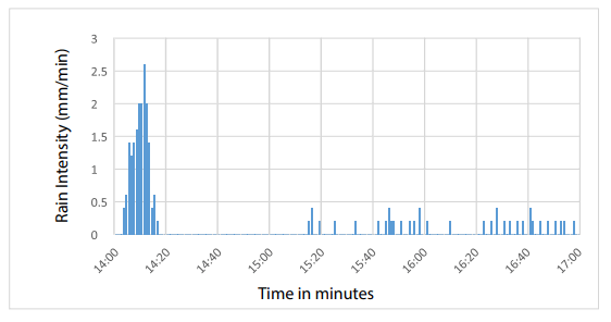
Figure 11: Rainfall in the extreme rain event of October 25 2015.
Discussion
Understanding hill slope runoff generation is a central problem in predicting flood frequency, sediment supply, sediment deposition, and sediment removal along the channel. This issue is critical in dry land areas, where slight changes in surface properties may have differential effects on overland flow generation. In addition, the great variability of surface properties, at the scale of few square meters, may limit data transference from one scale to another [3]. In addition, the specific location of the runoff plots, and data analysis, may affect the conclusions. The main purpose of the present work was to understand the hydrological processes at a scale of few square meters, in a variety of surface properties, over different geological formations, where differential weathering processes affect surface properties, under the same rainfall regime. Needless to say, weathering processes of limestone, granite and sandstone would not be expected to generate uniform surface properties in dry land areas. In the absence of a soil layer, and a vegetation cover, the issue of overland flow in extremely dry areas would be expected to depend on the hydrological role of impermeable factors such a bare rocky surface, or a stone cover over a rocky surface. The effect of stone cover on runoff has attracted the attention of many workers [19-21]. Most studies have been conducted in agricultural areas where the stone cover is underlain by a soil substratum that absorbs part of the runoff supplied by the stones. Nevertheless, in arid areas, devoid of a soil layer, the rainfall impact factor on a soil surface is irrelevant. Under such conditions bare rocky surfaces would be expected to quickly generate runoff. A bare rocky surface, partly covered by stones, would be expected to develop less runoff, due to the occurrence of local small depression storage. Needless to say, the hydrological effect of these depressions may be critical in areas with low storm rain amounts, as registered in the study area. Stone size is an important factor in overland flow generation. A positive relationship can be expected between stone size and overland flow, as bigger stones provide more runoff than smaller stones, especially over steep rocky surfaces. Data obtained clearly show that the frequency and magnitude of overland flow generation are higher over rocky surfaces than over colluvial surfaces. This may be explained by two factors: 1. A much higher roughness of the surface over the colluvial plots, related to the higher stoniness.2 due to the higher clay content, of eolian origin, in the layer below the surface from eolian origin. However, significant differences exist also among the rocky surfaces, as well as among the colluvial surfaces. The lowest rainfall threshold for runoff generation was obtained over the Salomon sandy formation, characterized by a very smooth and compacted surface (Figure 7). The lowest runoff, over a rocky surface, was obtained in the rocky siltstone plot (Figure 10). The explanation proposed is the degree of compaction of the surface. The sandstone is very compacted and responds quickly to rainfall. In the case of the siltstone plot, the upper surface layer is less compacted, and friable, allowing some infiltration, especially in days with low rain amounts. Similar differences exist between the granite and the limestone plots. The frequency and magnitude of runoff generation are higher over the limestone rocky plot than over the granite plot. The explanation proposed is as follows: the thinly bedded limestone weathers into flat thin strap boulders, 20 cm-40 cm long, that cover the underlying bedrock (Figure 3). Depressions storage is limited. On the other hand, the weathering of the granite rock, composed of different minerals, weathers into different stone dimensions, leading to more depression storages (Figure 5). The same applies to the difference between the colluvial plots. Overland flow is higher over the limestone colluvial plot than over the granite colluvial plot.
Conclusion
Data obtained refer to several important issues in geomorphology and hydrology:
The first issue is: Does the spatial location of the plots reflect properly each of the geological formations. Certainly not spatial differences in surface properties do exist within each of the geological formations in the study area. Nevertheless, the important result is that on the whole, the threshold of rain amount required for runoff initiation over all rocky plots is quite low, despite the prevailing low rain intensities. The second issue is: Data obtained bring us back to several important issues in geomorphology. The first is the possibility to extrapolate data from one area to another area, under the same rainfall regime. Data obtained point to a very limited possibility to extrapolate data from one area to another area under the same rainfall regime. This issue has been recently discussed in a recent manuscript for a semi-arid area (Yair). The third issue is: In view of the great spatial variability in runoff generation over a relatively small area, can we extrapolate data from one scale to another? The fourth issue is: The geomorphic importance of frequent events versus rare geomorphic events. Data obtained clearly show that under the rainfall regime prevailing in the study area, characterized by a high frequency of low rain amounts, and low rain intensities, only extreme rain events, usually connected to the Red Sea Through climatic regime, play an important role in channel flow generation. In terms of landscape evolution data obtained reflect the two rainfall regimes prevailing in the area. The Mediterranean regime, characterized by low rain storm amount, and low rain intensities, may be regarded as responsible for the development of colluvial deposits that limit the degree of connectivity at the hill slope-channel interface. The degree of disconnectivity would be expected to increase with increasing slope length [1]. The explanation proposed is: the concentration time required for a continuous flow along long hill slopes is longer than the duration of most effective rain showers prevailing under the Mediterranean rainfall regime. Finally, where are the areas contributing to channel runoff located: The major contributing areas are located in the small watersheds, located at the head-waters areas, where short rocky hill slopes, devoid of colluvial deposits, drain directly into the adjoining channel. Such a pattern fits the concept of "Partial area contribution observed in humid areas.
Acknowledgements
The study was supported by the Dead Sea and Arava Scientific Research Center. Thanks are due to Mr Shlomy Yanay for his assistance in the field work, and to Mrs M. Kidron, of the Department of Geography, at the Hebrew University of Jerusalem, for drawing the illustrations
References
- Abrahams AD, Parsons A (1991) Relation between infiltration and stone cover on a semi-arid hill slope, Southern Arizona. J Hydrol 122: 49-59.
- Agassi M (1970) The influence of stone cover on infiltration and erosion rates M.Sc. thesis Hebrew University of Jerusalem. pp81.
- Belachsen, Idit, Francesco M, Nadav P, Efrat M, et al. ( 2017) Convective rainfall in a climate: Relations with synoptic systems and flash-floods generation in the dead sea region. Hydrol Earth Syst Sci 21: 5165-5180.
- Beith M, Segev A, Ginat H (2013) Stratigraphy and structure of the timna stratigraphy valley and adjacent mining areas ministry of energy and water resources. Geological Survey of Israel.
- Cammeraat El (2004) Scale dependent thresholds in hydrological and erosion response of a semi-arid catchment in Southern Spain. Agric Ecosyst Environ 104: 317-332.
- De Boer DH (1992) Constraints on spatial transference of rainfall-runoff relationships in semi-arid basins drained by ephemeral streams. Hydrological Sci J ens 37: 491-504.
- Epstein J, Grant WJ, Struchtemeyer RA (1966) Effects of stones on runoff, erosion, runoff and soil moisture Influence of the coarse fraction in two main potato soils on infiltration, runoff and erosion. Soil Sci Soc Am Proc 23: 391-394.
- Goodrich DC, Keefer TO, Unlrich CL, Nichols MH, Osborn HB, et al. (2008) Long term precipitation data base, Walnut Gulsh experimental watershed. Water Resour Res 44: 1-5.
- Goodrich DC, Lane LJ, Shilito RM, Miller SN, Syed KH, et al. (1997) Linearity of basin response as a function of scale in a semi-arid watershed. Water Resour Res 33: 2951-295.
- Jung J (1960) The influence of the stone cover on runoff and erosion on slate soil. Publ int Ass sci Hydrol 53: 143-153.
- Kahana R, Ziv B, Enzel Y, Dayan U (2002) Synoptic climatology of major floods in the Negev desert, Israel. Int J Climatol 22: 867-882.
- Kamp SK, Faulconer J, Shaw JR, Lefsky M, Wagenbrenner JW, et al. (2018) Rainfall thresholds for flow generation in deserts ephemeral streams. Water Resour Res 54: 9935-9950
- Kirkby M, Bracken L, Reany S (2002) The influence of land use, soils and topography on the delivery of hill slope runoff to channels in SE Spain. Earth Surf Process Landf 27: 1459-1473.
- Kirkby MJ, Bracken LJ, Shannon J (2005) The influence of rainfall distribution and morphological factors on runoff delivery from dry land catchments in SE Spain. Catena 62: 136-156.
- Lamb J, Chapman JE (1943) Effects of surface stones on erosion, evaporation, soil temperature and soil moisture. Agron J 35: 567-578.
- Lavee H, Poesen J (1991) Overland flow generation and continuity on stone-covered soil surfaces. Hydrol Process 5: 345-360.
- Lavee H, Poesen J, Yair, A (1997) Evidence of high efficiency water- harvesting by ancient farmers in the Negev Desert, Israel. J Arid Environ 35: 341-348.
- Osborn HB, Lane L (1969) Precipitation-runoff relations for very small semi-arid rangelands watersheds. Water Resour Res 5: 419-425.
- Poesen J, Ingelmo SF, Mucher H (1990) The hydrological response of soil surface to rainfall as affected by cover and position of rock fragments in the top layer. Earth Surf Process Land f 15: 653-571.
- Puigdefabregas J, Sole A, Gutierrez L, Bario DG, Boer M et al. (1999) Scales and processes of water and sediment redistribution in dry lands: Results from the rambla honda field site in SE Spain. Earth-Sci Rev 48: 39-70.
- Martinez MM, Albaladejo J, Castillo VM (1998) Factors influencing surface runoff generation in a Mediterranean semi-arid environment: Chicamo watershed, SE Spain. Hydrol Process 12: 741-754.
- Valentin C, Casenave A (1992) Infiltration into sealed soils as influenced by a gravel cover. Soil Sci Soc Am Proc 56: 1667-1673.
- Wieler N, Avni Y, Rosensaft M, Whittaker OL (2017) Variations in hill slope runoff detected using geological strata coupled with vegetation patterns: Implications on spatially distributed desert runoff agriculture. J Landsc Ecol 10: 189-212
- Wolman MG, Miller JP (1960) Magnitude and frequency of forces in geomorphic processes. J Geol 68: 54-74.
- Wolman MG, Gerson, R (1978) Relative time scales of time and effectiveness of climate in watershed geomorphology. Earth Surf Process Landf 3: 189-208.
- Yair A, Klein M (1973) The influence of surface properties on flow and erosion processes on debris covered slopes in an arid area. Catena 1: 1-18.
- Yair A, Kossovsky A (2002) Climate and surface properties: hydrological response of small arid and semi-arid watersheds. Geomorphology 42: 43-57
- Yair A, Raz-Yassif, N (2004) Hydrological processes in a small arid catchment: scale effects of rainfall and slope length. Geomorphology 61: 155-169.
- Yair A, Lavee, H (1976) Runoff generation process and runoff yield from arid talus slopes. Earth Surf Process Landf 1: 235-247.
- Ziv B, Dayan U, Kushnir Y, Chaggi R, Enzel Y et al. (2006) Regional and global atmospheric patterns governing rainfall in the Southern Levant. Int J Climatol 26: 55-73
 Spanish
  Chinese
  Russian
  German
  French
  Japanese
  Portuguese
  Hindi
Hindi 