Special Issue Article, Geoinfor Geostat An Overview Vol: 0 Issue: 0
A Geographic Information System for Outdoor Markets
Cappello C*, De Iaco S and Giungato G
Dipartimento di Scienze dell’Economia, Università del Salento, Complesso Ecotekne, Via per Mon-teroni, Lecce (Italia), Italy
*Corresponding Author: Cappello C
Dipartimento di Scienze dell’Economia, Università del Salento, Complesso Ecotekne, Via per Monteroni, Lecce (Italia), Italy
Tel: +(39) 0832298774
E-mail: claudia.cappello@unisalento.it
Received: May 13, 2019 Accepted: June 28, 2019 Published: July 05, 2019
Citation: Cappello C, De Iaco S, Giungato G (2019) A Geographic Information System for Outdoor Markets. Geoinfor Geostat: An Overview S2.
Abstract
Trade management in public areas requires the availability of homogeneous and reliable data, as well as the use of advanced tools in order to store and process the large amount of information. In this context, the implementation of a Geographic Information System (GIS) and a Web-GIS for outdoor markets improves the levels of efficiency, effectiveness and quality of public services. In particular, the use of a GIS is advantageous to manage the available information, plan enhancement activities aimed at modifying the market areas and their services, support environmental, socioeconomic and trade analyses.
Keywords: Trade in public areas, Web-GIS, Relational models
Introduction
In recent years, Geographic Information System (GIS) and related technologies, such as Web-GIS, have been widely implemented for supporting local governments. The initial implementation [1-4] were limited to query and display maps, then new applications are devoted at support complex analyses for ad hoc decision making [5-9].
In this context, a challenge for local governments is to use new technologies (such as GIS and Web-GIS) in the strategic plan for outdoor markets, since it is evident that if the outdoor markets are properly planned and organized, then they can contribute to enhancing and revitalizing the urban spaces where they are placed. Moreover, a strategic planning of the itinerant retail business can play a positive role in promoting other forms of trade. In other words, outdoor market can become “attractive factor” of new customers and can help traditional shops by expanding their catchment area. In Italy, the trade on public areas is governed by the law 205/2017, which specifies the duties of local authorities. In accordance with this national law, Regions were required to transpose it in a regional law. In particular, Apulia region, through the planning and re-organization of trade on public areas (regional law 27/2017), requires the Municipalities to draw up trading plans for public areas (outdoor markets, among others) and to plan where locate market stalls, establishing exclusive licenses for the sale of specific products.
In this paper, the general characteristics of the available data for outdoor markets of some Municipalities of Lecce districts (Valle della Cupa Consortium), Italy, are described. Moreover, the different steps to create a GIS [10] and a Web-GIS for the management of the outdoor markets in the selected Municipalities, are discussed.
Special attention is paid to the integration of the existing data on the market areas, which are in different formats and come from different sources, such as the consortium of traders on public areas (CTPA), trade offices of each Municipality and Chamber of Commerce of Lecce.
Hence, through this GIS, the final user can acquire new data and integrate the old ones. Moreover, the GIS for the management of outdoor markets through the digitization of spatial information, allows the implementation of an adequate planning of the public areas with positive effects on the organization and the management of the itinerant retail.
Methodology for GIS Project Management
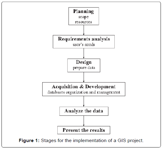
The Geographic Information System was developed in early 1960’s. It is well known that a GIS is a useful system for integrating, storing, editing, analyzing, sharing and displaying geographical information [11]. Hence, several steps must be followed in order to guarantee a GIS’ successful development and implementation. The different stages for the implementation of a GIS are shown in Figure 1.
In particular, in the design of a successful GIS, it is necessary to consider all elements of the decision loop in order to maintain high quality data and optimize the decision process.
Hence, in the first step of GIS project management it is important to determine the aim of the study, define the required outcomes and identify data needs. Then it is useful to prepare a plan for GIS use, or rather, the data-set to be used, assess the different types of relationships between databases (db) and the methods for processing the same data and, finally, the analytical techniques to be applied.
A further step for GIS’ implementation concerns the integration and data acquisition procedure. At this stage, the check procedure of archiving databases ensures data completeness and correctness. Moreover, in some cases, it might be advisable to convert and manipulate the data. This operation consists in transforming raw data into formats that can be used directly by the GIS to perform manage data in further steps. After the integration and data acquisition step, the data have to be processed through appropriate procedures of spatial analysis, i.e. georeferencing, topological overlay, queries and other GIS functions.
Finally, the data integrated in the GIS will be used in order to aid decision making. In the following, the aforementioned stages for the creation of a GIS project for outdoor markets will be discussed. Particular attention will be paid to describe the implemented relational model for trading in outdoor market.
Data collection
The GIS project for outdoor markets has been developed for the 12 Municipalities (Arnesano, Cavallino, Lequile, Lizzanello, Monteroni di Lecce, Novoli, San Cesario di Lecce, San Donato di Lecce, San Pietro in Lama, Squinzano, Surbo, Trepuzzi) of Valle della Cupa Consortium, located in the North of Lecce district, Italy, since the Consortium is devoted to the organic development of the area and strategic management of the territory. In particular, the objectives of the Consortium are further pursued by new strategies aimed at the development and revitalization of the market areas.
Hence, the development of a GIS project for outdoor markets has required to collect information from different sources, such as public institutes (i.e. Municipal Offices and the Italian National Statistical Institute-ISTAT) and private institutions (i.e. chamber of commerce, industry, crafts and agriculture of Lecce and CTPA of Lecce), by sending a specific data request at each Municipal Office or downloading the data from the Municipality websites. Note that the data request has been sent to each Municipality of Valle della Cupa Consortium.
In particular, the following information have been included in the GIS project:
• Administrative features, which are vector data represented by polygons, in shapefile format (.shp) and concern the municipal boundaries, as well as the boundaries of the urban centers, as shown in Figures 2a and 2b;
• Municipal road network, which are vector data represented by lines, in shapefile format (.shp) and concern the principal arterial roads and the roads of minor importance, destined for transport, as shown in Figure 2c;
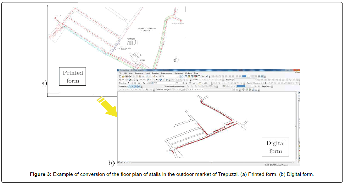
• Contour-planimetric maps of market areas, which have been provided by municipalities in printed form or .dwg format, and successively converted in shapefile format (Figure 3);
• Map of the stalls for each outdoor market;
• Orthophoto of the area under study, obtained by connecting the Open Geospatial Consortium (OGC) to the Web Map Service (WMP) standard protocol, which is necessary for a better description of the areas under study.
The aforementioned data, which concern the Municipalities and outdoor markets, combined with
• data on resident population, for each Municipality (i.e. number of inhabitants, number of families, number of males and females);
• data on the different characteristics of the stalls (i.e. surface, product category);
• personal data of stall’s holders (i.e. first and second name, birth-date, birth-place, nationality, residence address, telephone number);
• commercial data of the operators in fixed places (such as traditional shops), classified by sector of commodity activity, for each Municipality under study can be used, through the GIS technology, to formulate development activities of the outdoor markets.
Database design
As previously specified, in the creation of a GIS project, the organization of the collected data in a geo-database represents a crucial step. In particular, in the case of a GIS for the outdoor markets three different databases (db) have been defined:
1. the marketplace’s db;
2. the stalls’ db;
3. the stall holders’ db.
The marketplace’s database: In this database the data provided by the Municipal Offices and the Municipal Police Offices of Valle della Cupa Consortium have been stored. This set of data regards, for each outdoor market, some basic information, i.e.:
• location;
• market frequency (weekly, biweekly);
• opening date;
• opening time;
• number of stands;
and some auxiliary information, which can be unavailable, and concern structural elements of the area close to the outdoor market, i.e.:
• location of toilets;
• parking areas;
• areas for recycling bins;
• bike path;
• traffic-free zone;
• bus lines;
• supervisory service in the outdoor market.
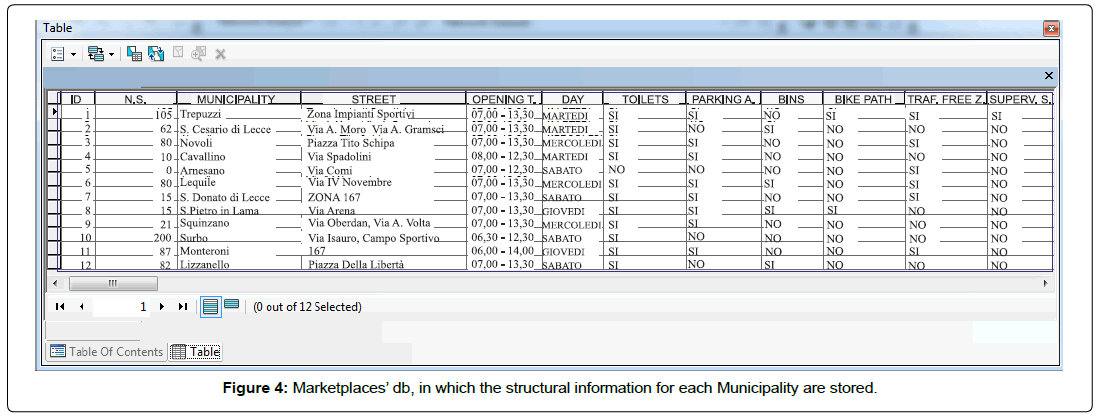
In Figure 4 the marketplace’s db is shown. This table consists of 12 records, one record for each Municipality belonging to the Valle della Cupa Consortium. In each record, the structural information regarding each marketplace are stored.
The stalls’ database: In the creation of a GIS project for market areas, it is necessary to include information on each stall, which is a portion of the public area that the Municipality gives to each authorized seller. Hence, the information provided by the board of trade of each Municipality or by CTPA regarding available stands have been integrated in a unified database, in which the following features are recorded:
• the number of the stalls;
• stall holder’s personal details;
• dimension of each stall (sq.m.).
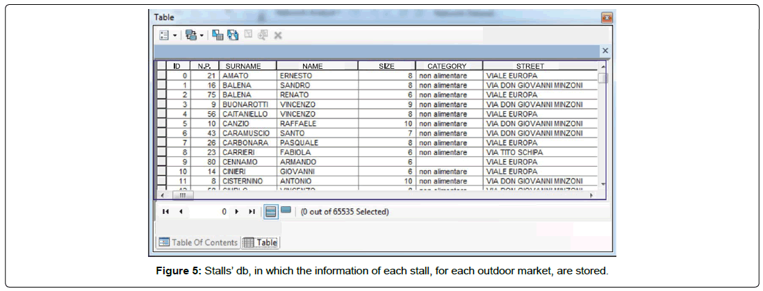
In the stalls’ database the main characteristics of the 65535 stalls, which are located in the 12 outdoor markets of Valle della Cupa Consortium, are provided (Figure 5). Note that the field “N.P.” denotes the identification code of the stall and the field “size” is the dimension (sq.m.) of the stand. Moreover, the name and surname of the stall holders (fields “name” and “surname”) are provided. Further information stored in the database regards the type of goods (field “category”) and the spatial location of the stand (field “street”).
It is important to point out that this database is a useful tool for Municipal Offices, since it contains in a unified way all the information collected from different offices, hence it can be easy to monitor and manage the existing stalls and it could facilitate the allocation of new stands.
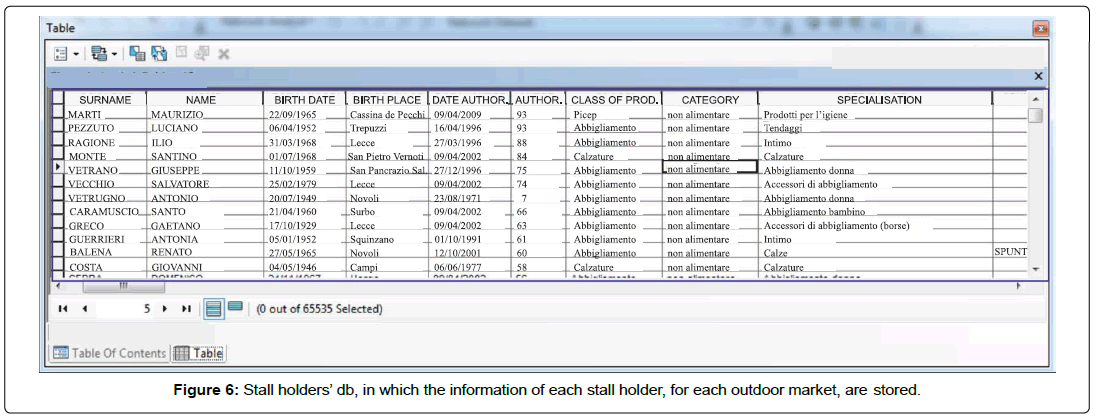
The stall holders’ database: The personal information on itinerant traders have been provided by the CTPA of Lecce and by the Municipal Police Departments of each Municipality. The collected data have been integrated with the data given by the board of trade of each district. Hence the complete database (Figure 6) of stall holders contains, in each record, personal details of the trader (i.e. first and second name, birth-date, birth-place, residence address), authorization date and the corresponding identification number, size of the stall and type of good sold (food category/no food category). In this database the data of pop-up stall holders are also stored, i.e. traders staying in the outdoor market for a limited time only, in spite of other stall holders, who operating every week/day.
A relational model for trading in an outdoor market
The aforementioned databases have been converted into a format supported by ArcGIS [12], which is a commercial GIS software, and then have been imported in ArcMap, an application of ArcGIS, with the corresponding shapefiles, in which are stored the related geographic information. The data on the outdoor markets, stalls and stall holders have been integrated with other vector data regarding the data on resident population in Valle della Cupa Districts, the administrative boundaries, the urban centers and the street networks.
In order to properly use all the collected data in a GIS project, it was necessary to define a relational model between the databases. This model is useful to manage the relationship between the different, independent and unrelated databases.
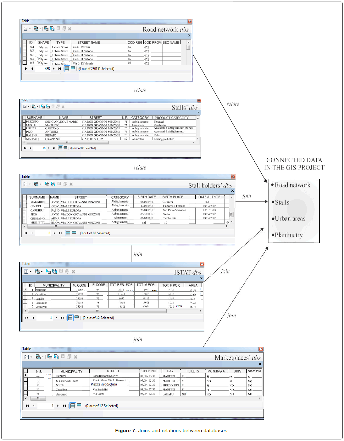
In Figure 7 the relational model for the proposed GIS project and the relationships between the databases and the geo-referenced objects are shown.
Note that the relational model considers the database tables and their relationships through the join and relate operations.
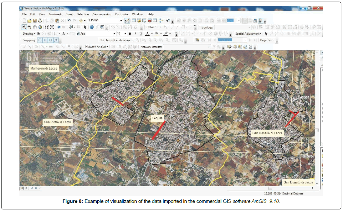
In particular, the relate operation associates the street network database with the stalls’ and stall holders’ databases. Moreover, it has been defined the join operation that links at each stall the corresponding stall holder. In addition, the outdoor markets’ database and the ones with the data on resident population in each Valle della Cupa Municipality has been linked, by a join operation, with the ISTAT demographic database, in order to visualize, for each outdoor market, the number of inhabitants (classified by age and gender) and the number of families, for the selected district. In Figure 8 an example of data view is proposed.
This GIS project allows to the final user, such as local administration employees to easy verify, by selecting a stall, if the stand has been assigned to a trader or not, monitor the payment of the public land occupation fee (public space and public space occupancy tax) by each stall holder and finally provide details about the size of the stall, the type of good sold and stall holder’s personal data.
Hence, the policy makers can use the aforementioned information for planning the re-organization of the marketplace, for allocating unoccupied spaces to pop-up stall holders or for revitalizing the urban spaces where outdoor markets are placed.
Discussion
A Web-GIS for outdoor markets
As previously specified, GIS allows cartography enrichment by adding cartographic information to graphical representations, moreover a Web-GIS, which is a GIS characterized by online accessibility of geographic data, real time data update and selection of geographic information by themes, lets to share maps and data with all web users [13-15].
Hence, the main feature of a Web-GIS is the usage of world wide web standard formats and protocols, to make available geographical data from any web browser. Moreover, it is important to highlight that the Web-GIS users are both local users, i.e. technicians and researchers (similarly to GIS users) and online users, i.e. technicians and citizens.
In recent years, the use of Web-GIS apps is becoming more and more common due to the necessity to find and share geographical data. In particular, in order to integrate a GIS project in a Web-GIS, it is necessary that GIS standards for data formats are satisfied. Note that the GIS standards concern the use of the geographic information in a common format, which are used to transfer spatial data via web or to access to the spatial data stored on a web server. These standards optimize spatial operations and improve data quality.
In this Section, a description of the new Web-GIS for trading on outdoor market is provided. This Web-GIS includes the tabular information stored in the GIS project previously developed.
It is important to point out that the realization of the Web-GIS requires the use of specific softwares for the online data access, such as Open Source Map Server [16] and the p.mapper 4.1.1. for the graphical user interface.
In particular, the development of Web-GIS for outdoor markets has required the use of the following layers:
• state, provincial and municipal roads;
• administrative and urban center boundaries;
• data to support the citizen to get the outdoor markets, such as cycling areas, bus stations, main squares, parks;
• data related to outdoor markets, such as stalls and standings locations.
Note that the Web-GIS functions are similar to the ones of GIS. For example, by selecting the layer related to the administrative and urban center boundaries, the provincial boundaries are also visualized. Moreover, by accessing to the identify tool, the data on the resident population related to each Municipality are visualized.
On the other hand, the layer for urban center boundary has been associated with stalls’ database. In this way, the Web-GIS users, such as Municipal clerks, citizens and tourists, can find information related to itinerant retail trade in the Municipalities belonging to the Valle della Cupa Consortium.
In the Web-GIS for outdoor markets, particular attention has been paid to developing different tools for querying the databases.
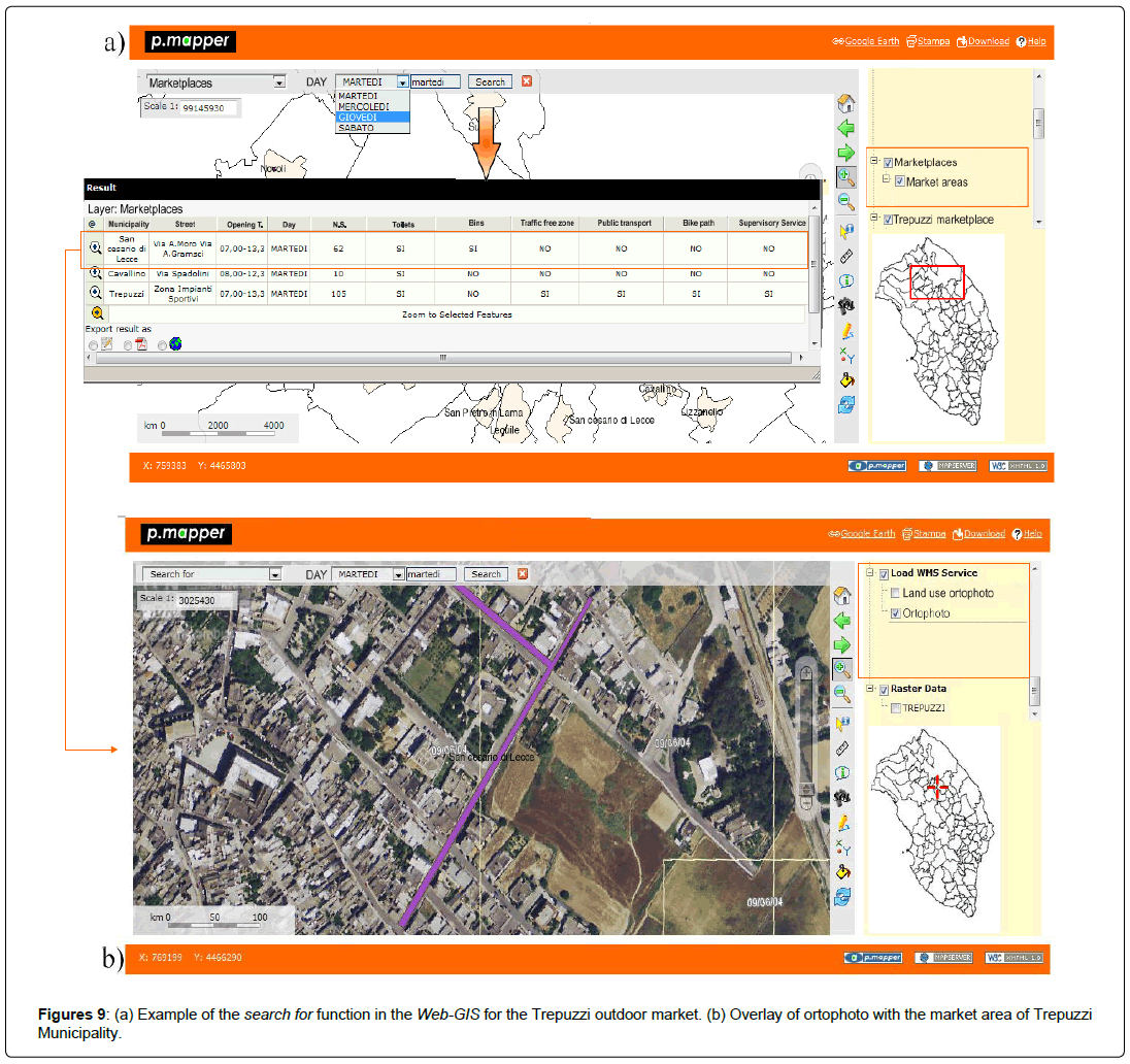
In particular, by using the main layer of outdoor markets, the search for function, allows the visualization, for any day of the week, of the Municipalities where market takes place. Note that the output of the query is an attribute table in which each row represents the Municipality where market takes place, furthermore the columns are the different attributes of the marketplace. Hence the results of the query is a subset of the marketplaces’ database (Figure 9a). Moreover, the user can export the results and choose the file format to save the file in, the formats supported are csv, pdf and shapefile. Finally, by selecting a specific outdoor market (zoom to selected function) on the map the streets where the market takes place are visualized (Figure 9b).
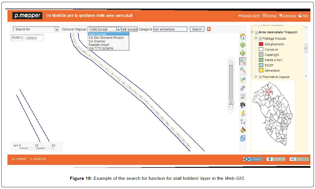
The search for tool takes on great importance in the layer of outdoor market. Indeed by selecting a specific Municipality and a specific street, an attribute table containing a list of stalls, in the chosen street, is given. Note that in the table the characteristics of the stalls (i.e. the dimension, the type of goods sold and stall holder’s personal details) are stored, hence the result of the query is a subset of the stalls’ database. Moreover, the spatial contents of the attribute table are also shown on the thematic map, as shown in Figure 10.
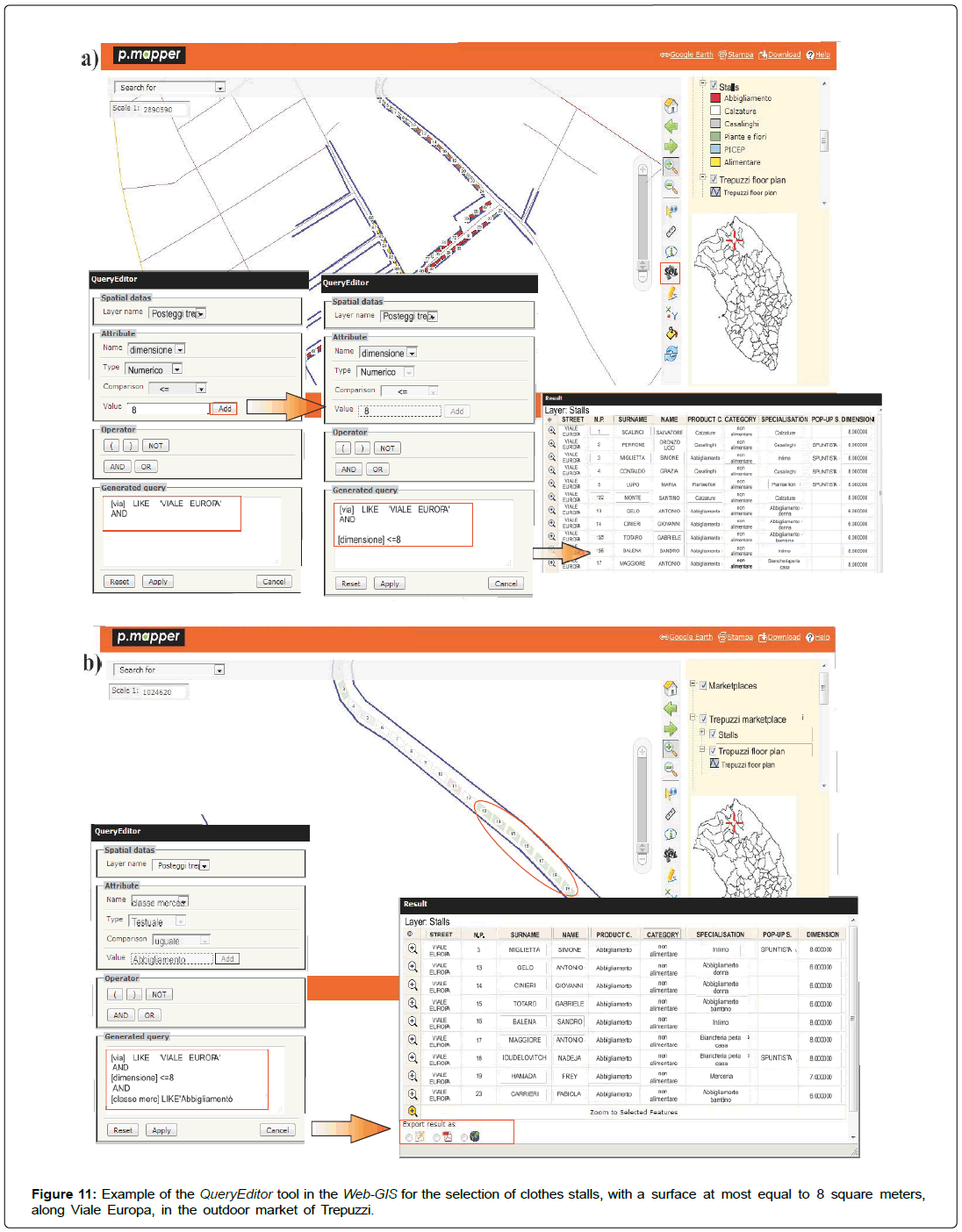
A further tool, implemented in the proposed Web-GIS, is the QueryEditor, which is useful to select attributes in the databases associated to the layers.
In Figure 11a an example of thematic map and attribute table, as possible output of the Query Editor, for the outdoor market of Trepuzzi is proposed. In particular, the stalls located in a selected street (Viale Europa), which are not greater than 8 square meters are shown. Note that the output of this query is a table of 14 rows, in which each row is associated to a stall holder. Hence, the information available in stalls’ database and stall holders’ database are reported in the attribute table. However, the user can also add, in the same screen, a further query (Figure 11b) and the corresponding output can be saved or exported in different formats (i.e. cvs, pdf or shapefile format).
Conclusion
In recent years, Municipalities have to provide services to citizens through the use of informative tools which allow archiving and visualizing data from different sources. The main challenge is to make information available to a large number of users.
In this context, GIS technology is becoming an integral part of the information infrastructure in public and private organizations. The integration capabilities of a GIS allow collecting data sets in order to create a representative image of phenomena under study. Thanks to GIS technology, relationships, connections and patterns, which are not always evident in the data set, are highlighted and the outputs of GIS projects enables organizations to make better decisions based on the relevant investigated factors. Hence each public or private organization is able to share, coordinate and communicate key concepts between offices or between organizations using GIS as the central spatial data infrastructure.
Usually a Web-GIS is used for environmental monitoring and natural resource management, the novelty of this paper regards the use of GIS and Web-GIS technologies for supporting a Consortium of Municipalities in the management of public services, i.e. outdoor markets, through the integration of data from multiple data sources. In particular, the development of a GIS project for outdoor markets of Valle della Cupa Consortium of Municipalities and its implementation in an interactive and user-friendly Web-GIS will enables policy makers in local governments and in decision support, improving the efficiency and effectiveness of the decision making process and data sharing. For example, the geographic information system will help policy makers to monitor and plan future improvements for outdoor markets, or measure its attractiveness. Moreover, the GIS project could be used by citizens or tourists to know where the stands, grouped by product category are located, or if the location is accessible by public transport. Finally, it is worth noting that the GIS and Web- GIS systems for outdoor markets are based on data (marketplaces’ db, stalls’ db, and stall holders’ db) which change over time, since a yearly update of these databases is required, in order to guarantee continuous improvements of the effectiveness and efficiency decision making processes.
References
- Campbell H and Masser I (1992) GIS in local government: Some findings from Great Britain. Int J Geogr Inf Syst 6: 529-546.
- Chrisman N (1987) Design of geographic information systems based on social and cultural goals. Photogramm Eng Remote Sens 53: 1367-1370.
- Bolstad P (2005) GIS fundamentals: A first text on geographic information systems. Eider Press, Minnesota.
- Lo CP and Yeung AK (2007) Concepts and techniques of geographic information systems. Pearson Education Canada Inc, Toronto.
- Chrisman N (2002) Exploring geographic information systems. John Wiley and Sons, Toronto.
- Rana S and Sharma J (2006) Frontiers of geographic information technology. Springer, London.
- Sieber R (2006) Public participation geographic information systems: A literature review and framework. Ann Assoc Am Geogr 96: 491-507.
- Kadiyala MD, Nedumaran S, Singh P, Chukka S, Irshad MA, et al. (2015) An integrated crop model and GIS decision support system for assisting agronomic decision making under climate change. Sci Total Environ 521: 123-134.
- Keenana PB and Jankowskib P (2019) Spatial decision support systems: Three decades on. Decis Support Syst 116: 64-76.
- Wong D and Lee J (2005) Statistical analysis of geographic information with ArcView GIS and ArcGis. J Wiley & Sons, Toronto.
- Heywood DI, Cornelius SC, Carver SJ (2006) An introduction to geo-graphical information systems. Pearson Education.
- http://desktop.arcgis.com/en/arcmap/
- Dragicecic S (2004) The potential of Web-based GIS. J Geograph Syst 6: 79-81.
- Schimiguel J, Baranauskas M and Medeiros CB (2004) Inspecting User Inter- face Quality in Web-GIS Applications. GeoInfo.
- Kraak MJ (2004) The role of the map in a Web-GIS environment. J Geograph Syst 6: 83-93.
- Kropla B (2005) Beginning mapserver. Springer, New York.
 Spanish
  Chinese
  Russian
  German
  French
  Japanese
  Portuguese
  Hindi
Hindi 