Research Article, Geoinfor Geostat An Overview Vol: 6 Issue: 2
Revealing of Land Use Conflicts at Indigenous Population Territories in the Russian Arctic Using Atlas Information Systems Methodology
Evseev AV, Krasovskaya TM*, TikunovVS and Tikunova IN
Geographical Faculty, Lomonosov Moscow State University, Moscow, Russia
*Corresponding Author : Krasovskaya TM
Professor, Geographical Faculty, Lomonosov Moscow State University, Moscow, Russia
Tel: +7(495)9392238
E-mail: krasovsktex@yandex.ru
Received: February 3, 2018 Accepted: February 20, 2018 Published: February 27, 2018
Citation: Evseev AV, Krasovskaya TM, TikunovVS, Tikunova IN (2018) Revealing of Land Use Conflicts at Indigenous Population Territories in the Russian Arctic Using Atlas Information Systems Methodology. Geoinfor Geostat: An Overview 6:2. doi: 10.4172/2327-4581.1000180
Abstract
Declaration of transit to sustainable development in the Russian Arctic zone mentioned in recently adopted Federal programs draws attention to risks of different nature management conflicts emergence, connected with mainly industrial development vector. These conflicts may appear at territories of traditional nature use (TTNU) of indigenous population. Special research is needed to present these risks origin and reveal territories of their possible emergence Methods of land use conflicts at indigenous population traditional land use territories in the Russian Arctic are described. They are based on ecosystem services exploitation analysis using specially elaborated conflict matrix. Panarchy theory provides the conceptual base of this research. Our research focuses on management of heterogeneous regional ecosystems variables at TTNU presented by ecosystem services, ethnic-cultural data and overlapping modern land use patterns. System analysis was
the principle research method .It was based on processing of ecological, economic, ethnic-cultural etc. published data and statistics as well as long-term field investigation experiences in the Arctic. Atlas Information Systems (AIS) methodology was used for visualization of conflicts distribution patterns. Data base within AIS included statistical data, thematic maps, descriptions etc. Visualization of such data base in AIS media enabled to compile a chorographic nature management conflicts. 3 variants of conflicts are shown: the already existing, developing and potential. In each case ecosystem services exploited in different competing types of
nature management at TTNU are presented. Our research demonstrated that territorial planning procedure for TTNU must include compiling of conflict matrixes especially in case of low supply of a certain ecosystem service (for example-ecological assimilation potential).Modern ecological-economic methods enable to receive primary monetary assessment of relatively broad spectrum of ecosystem services thus revealing their possible contribution to regional economy development.
Keywords: Russian arctic; Land use; Indigenous peoples; Ecosystem services; Conflicts; Mapping; Atlas information systems
Introduction
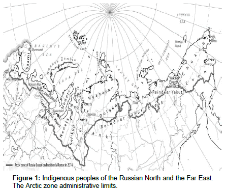
The 21st c. revealed a new look at the global functions of the Arctic: resource, climatic, geopolitical, communicative, ecological etc. Russia is a northern state which modern economy is closely connected with economic development of the Russian Arctic zone. Nowadays it produces 10% of GDP accommodating only 2.2% of population. Its terrestrial limits were discussed for more than a decade and at last adopted only after the President’s decree in 2014 (Figure 1). Series of important documents outlining plans for future development of this region were adopted during the previous several years [1-4]. Declaration of a sustainable development pattern in the Russian Arctic zone draws attention to several problems connected with further economic development. Possible emergence of different nature management/land use conflicts is among them, including conflicts at territories of traditional nature use (TTNU) of indigenous population.
Inspite of considerable recent achievements in institutional measures to solve these conflicts; methods of their revealing and preventing in pioneer regions of modern economy development are still inadequate. At the same time ignoring of such conflicts may lead to social destabilization, social-cultural degradation of indigenous minorities, inadequate natural capital exploitation etc. possessing obstacles at the way to sustainable development. The aim of this research is the analysis of land management conflicts and elaboration of methods how to reveal and map them at TTNU.
Study Area
Limits of our study area are administrative, adopted in 2014 (Figure 1). First of all this is connected with absence of maps presenting integrated limits of natural ecosystems and nature management patterns. Partly it is also connected with the fact that statistical information necessary for this study was available only within administrative regions. Its total area is about 6 mln km2, approximately half being terrestrial. Natural ecosystems are presented by tundra, forest-tundra and limited northern taiga areas. The number of indigenous population in the Russian Arctic within the recently adopted limits is 82 500 or about 3% from the total population in this region [5] (Figure 1). Part of indigenous peoples living in the Russian Arctic is still nomadic: from 5% up to 50-80% in Yamalo-Nenets Autonomous Okrug (region) [6]. Indigenous people’s traditional nature management includes: reindeer breeding, hunting, fishing, wild plants picking. In its historical variant (i.e. before market relations development) it was mostly ecologically friendly due to traditional ecological knowledge [7]. Family-clan territories presented nowadays are still managed in this way.
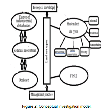
The following basic land use types are presented at the study area (Figure 2): industrial (mining, metallurgy etc.), residential, transportation, agricultural (mainly TTNU), forestry, recreational, nature conservation, open/vacant place (unused lands). Some of them are overlapping thus promoting nature management conflicts development.
Materials and Methods
Panarchy theory provides the conceptual base of this research [8,9]. Panarchy is a conceptual framework to assess complex systems stability and change. Management systems must take into account many dynamic features of ecosystems in order to be adaptive to the levels of critical ecosystem functions. Our research focuses on management of heterogenous regional ecosystems variables at TTNU presented by ecosystem services, ethnic-cultural data and overlapping modern land use patterns. System analysis was the principle research method. It was based on processing of ecological, economic, ethniccultural etc. published data and statistics as well as long-term field investigation experiences in the Arctic. Digital mapping was used for our results visual presentation.
Heterogenous data was processed with the help of Atlas Information system (AIS) tools. The earliest publications describing AIS are referred to the beginning of the 90-s and are connected with a famous Dutch cartographer Ferjan Ormeling et al. [10] in his work of Atlas information systems, he gives a definition of AIS as a computerized geographic information system associated with a certain territory or topic in conjunction with the narrative part, where maps dominated. Regarding our topic connected with characteristics of unique nature management systems of indigenous population of the North AIS seems to be the most suitable for spatial analysis method. The manual “Fundamentals of Geoinformatics” includes a chapter “Atlas information systems” where it is written that regarding their functional characteristics AIS may be referred to the top class of electronic atlases and sometimes are used for decision support, scenarios of territorial development elaboration etc. [11]. AIS include advanced modeling functions, may integrate expert systems and may be presented as a multimedia system. AIS enable visualization of geospatial data and various analysis even elaboration of possible development of such complicated systems as “nature-societyeconomy” at TTNU.
One of the most interesting AIS characteristic is possibility of its integration with decision support system [12]. Decision making is a special process of human activities directed at choosing of the best variant from several suggested. Analytic hierarchy process is used for management decision making based on spatial analysis within AIS. Analytic hierarchy method was suggested by T. Saaty (University of Pittsburg, USA) in the 70-s, 20th c. for modeling of multicriteria decision making tasks (DMT) [13].
The gist of this method is DMT structuration via construction of multilevel hierarchy, which unites all task elements of interest (main task, subtasks, driving forces, criteria, alternatives etc.) Later these elements are compared with each other using specially developed procedure. Quantitative evaluation of elements mutual impact intensity becomes possible in the result. This makes it possible to choose a suitability degree of the suggested alternatives regarding the main task. DMT for the study area enables to manage heterogenous data to find the best variant of land use pattern corresponding to sustainable development goals.
Results and Discussion
Nature management conflicts prevention at TTNU are in the focus of attention of the Arctic Council for many years. It’s sustainable Development Working Group (SDWG) deals with different aspects of development activities at TTNU and even published in 2011 The Circumpolar Information Guide on Mining for Indigenous Peoples and Northern Communities [14]. Several new relevant projects are planned for 2017-2019. GEF project ECORA (2004-2009)-An Integrated management approach to conserve biodiversity and minimize habitat fragmentation in three sectorial model areas in the Russian Arctic presented solutions for co-management of natural resources avoiding conflicts risks etc. [15]. Nevertheless, economic development in many Arctic regions of the World is still connected with nature management conflicts: marine mammals conservation and shipping in the coastal zone, timber cutting and mining development and Saami reindeer breeding in Norway and Sweden, oil extraction and northern minorities rights at the Mackenzie River deposit (Canada) [16-18] etc. Thus further studies of this problem may be helpful for management improvement to avoid the risk of conflicts appearance.
Types of conflicts and their origin
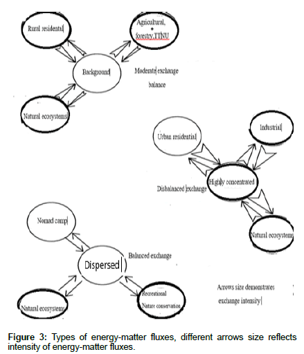
Nature management conflicts reflect disbalance of energymatter fluxes in the system “Nature-Population-Economy” (Figure 3) [19]. It may be connected with economic, ecological and social/ ethnic cultural factors often producing a joint effect [19]. In order to reveal such conflicts it is necessary to consider each of them. The following major groups of land use with different energy-matter fluxes patterns are presented at the study area: background, dispersed, highly concentrated (Figure 3). Intensive exchange produces nature management/land use conflicts. Special research is needed to assess these fluxes demonstrating high regional differences.
The most typical nature management conflicts at TTNU are represented in Table 1.
| Principle land use group | Producing conflicts at TTNU |
|---|---|
| Highly concentrated | Industrial, residential |
| Background | Forestry |
| Dispersed | Recreational, Nature Conservation |
Table 1: Typical types of nature management conflicts at TTNU.
Economic “promoters” of such conflicts are connected with different incomes provided by economy of TTNU and industrial, transportation, residential types of land use. Traditional production value of northern minority’s lands in modern economy is incomparable with that of oil and gas extraction for example which thus have priorities in land use planning.
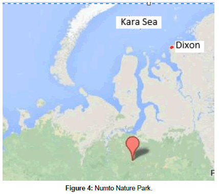
This conclusion may be supported by an example of the recent case of nature management conflicts at TTNU territories in the Numto Nature park, situated in the oil-rich Khunti-Mansi Autonomous Okrug-Ugra (Figure 4). According to Russian legislation land use patterns without negative environmental impact are possible in nature parks. Numto park territory was used by indigenous Nenets population mainly for reindeer breeding.
Rich oil deposits were discovered at the territory of this nature park and licences for their exploitation were issued by Ugra administration. Functional zoning plan compiled in order to separate territories of conflicting land use patterns i.e., industrial and traditional appeared to be inadequate to prevent land use conflicts [20]. The main problem was ignoring of ecosystem services resources available for exploitation and social-cultural [7].
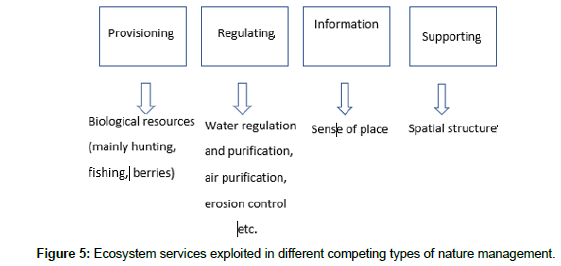
Ecological reasons are connected with uncontrolled ecosystems services exploitation revealing the “tragedy of the commons” [21]. “Competing” ecosystem services produced at TTNU are the following: provisioning (biological resources), regulatory (microclimatic, water filtration etc.), supporting (biochemical turnover ), cultural/ information (spiritual and historical, aesthetic, recreation etc.) [22]. Available volume of ecosystem services depends on natural conditions and differs from one territory to another. Modern methods enable to assess available volumes for many ecosystem services [23-25].
Social-cultural reasons are most often produced by different world outlook for indigenous and modern society (migrants to the North) which is reflected in different approaches to land use. For indigenous population nature is still sacral. Their land use pattern includes vast territories which newcomers accept as “vacant”. Ethic-cultural ecosystem services may be partly assessed as well [26]. Traditional ecological knowledge is a valuable resource for ecologically wise land use development preventing conflicts among different users [27,28].
Land use conflicts arenas
Conflicts of nature management at TTNU are characterized by two principal features: negative changes in ecosystems and human health. Both of them have the same origin: competing exploitation of ecosystem services beyond their supply limits. It may be clearly seen in modern impact regions (ecological hot-spots) comprising TTNU. Methods of their detection were described earlier [29]. Visual marks of ecosystems degradation, biological resources depletion (both forming resource base for TTNU) are typical in such regions. Table 2 presents information about northern minorities living in modern impact zones, types of anthropogenic load and was compiled due to our field data and recent publications.
| No | Impact region | Type od anthropogenic impact | Indigenous population |
|---|---|---|---|
| Coastal Arctic zone | |||
| 1 | Timano-Pechora | Hydrocarbons extraction | Nenets |
| 2 | Pur-Nadym | Hydrocarbonsextraction | Nenets, Sel’kups, Khanty |
| 3 | Norilsk | Mining-metallurgical industry | Nenets, Enets |
| 4 | The Yana-Indigirka | Mining industry | Chuckchi, Evens, Yukagirs |
| 5 | The Lower Kolyma | Miningindustry, transportation | Chuckchi, Evens, Yukagirs |
| 6 | Pevek-Valkumey | Mining industry, transportation | Chuckchi |
| 7 | Anadyr | Mining industry, transportation | Chuckchi, Evens |
Table 2: Indigenous population of the Russian Arctic living in modern impact regions.
Specific features of conflicts
Conflicts of landuse/nature management origin and types in the Russian North are common for other regions as well in general, but still have specific regional features. Their specific features include the following [19]:
• Large size of conflicts territories;
• Relatively young origin (about half of a century);
• Development in regions with limited resilience to anthropogenic load and unfavorable for economic development on climatic reasons and remoteness;
• Increasing variability because of climate change;
• Direct threat to the global biosphere buffer
• Possibility of social-ecological destabilization.
At the same time many conflicts may be avoided or mitigated if traditional ecological knowledge of indigenous population and their social organization experiences are considered. Development of partnership relations between regional administration and family-clan communities is of vital importance. Another important regulatory mechanism is providing nature capital ecologicaleconomic assessments for regulation of TTNU cadaster price and compensatory payments for their loss. Such assessments may reveal new advantages of TTNU in market economy.
Conflict matrix elaboration
Spatial analysis of nature management conflicts origin based on ecosystems services exploitation in competing land use patterns may be done using conflicts matrixes which reveal the exploited ecosystem services [19]. Matrix compiling is based on ecosystem structure studies. For example, territories with bogs ecosystem groups supply water purification, water regulation, and microclimatic etc. ecosystem services. Forest ecosystem groups supply air purification, erosion control, and microclimatic etc. ecosystem services. Matrix detailing depends on analysis scale. Field research enables to detect the most typical conflicts and reveal their origin (Table 3). It must be mentioned that ecosystems services spectrum may be limited by lack of necessary information both on their type and quantitative assessment methods. Typical nature management conflicts at TTNU are shown in Table 3. Figure 5 presents ecosystem services exploited in different competing types of nature management at TTNU, following the adopted classification [22].
| TTNU | Competing land use/nature management types and exploited ecosystem services | ||||
|---|---|---|---|---|---|
| Industrial | Marine transport | Terrestrial transport | Residential (nucleus) |
Recreational (hunting, fishing etc.) |
|
| Reindeer breeding | Regulating, supporting | - | Regulating, | Regulating, Supporting |
Regulating, cultural, supporting |
| Marine mammals hunting | - | Regulating | - | - | Cultural |
| Fishing | Regulating | - | Regulating | Regulating, provisioning | Cultural, provisioning |
| Hunting | Regulating, supporting | - | Regulating | Regulating, provisioning, supporting | Cultural, provisioning |
| Wild plants picking | Regulating, supporting | - | Regulating | Regulating, provisioning, supporting | Provisioning, supporting |
Table 3: Typical nature management conflicts for ecosystem services exploitation.
Ecosystem services
Large scale matrix compiling is based on information about ecosystem services produced by different ecosystem/landscape types within impact regions. Such types may be presented by the following rank groups- urochishe and mestnost’ according to Russian landscape classification system [30]. Small scale matrix may be compiled using land cover maps. In both cases social-economic maps are necessary (see below).
Mapping of nature management conflicts
Database for compiling a chorographic nature management conflicts map included the following:
• Administrative regions of the Russian Arctic zone [31];
• Maps of the existing and potential impact regions [29];
• Traditional nature management lands areas [32];
• Compact residential areas of indigenous population map [33];
• Ecological situation map at compact residential territories of indigenous population [34];
• Agriculture regionalization map of Russia [34];
• Hunting resources of Russia [34];
• Types of agricultural enterprises in Russia [34];
Visual fragments of AIS data base are presented at Figure 1. Reference data include Federal development programs for the Arctic, relevant regional documents, regional domestic product structure, patterns of conflicts at TTNU (Tables 1-3), Ecosystem services exploited in different competing types of nature management (Figure 4) etc.
These data was used for integrated analysis and visualization of spatial ecological and social-economic information completed by regional statistics and published ecological situation characteristics in order to detect nature management conflicts of different origin at TTNU. Misbalanced ecosystem services exploitation produces development of ecologically unstable territories of different ranks [38]. We marked these territories at the map by presenting spectrum of excessive exploitation of ecosystem services i.e. revealing the origin of nature management conflicts. Three types of conflicts: the already existing, developing and potential are demonstrated. They reflect the situation in impact regions developed in the 20th c., territories of modern and planned economic development.
Conclusion
In spite of advanced institutional support measures for preservation of TTNU [2] the most typical cause of nature management conflicts reflects “the Tragedy of the Commons” theory [21]. This is a tragedy because, in seeking their own personal gain, the members of one group actually ignore the rights of another group for ecosystem services leading to their exhaust, undermining ecological, economic and social stability of local population. “Commonwealth” in this case includes not only provision in ecosystem services (hunting, fishing, wild berries resources) used by indigenous minorities and to a certain extent by newcomers as well, but regulating, supporting and cultural services as well. Their poorly controlled consumption produces available ecosystem services deficiency. Their rapid restoration is hampered by many natural factors connected with geographical situation: slow biogeochemical turnover, low biological productivity, permafrost etc.). Developing nature management conflicts launch impact regions formation reflecting depletion of nature capital.
Territorial planning procedure for TTNU must include compiling of conflict matrixes especially in case of low supply of a certain ecosystem service (for example – ecological assimilation potential). Modern ecological-economic methods enable to receive primary monetary assessment of relatively broad spectrum of ecosystem services thus revealing their possible contribution to regional economy development. The decisive factor for non-conflict economy development in the Russian Arctic zone is active participation of indigenous family-clan communities in territorial planning activities (foreseen by Russian legislation). Ecological-economic assessments of ecosystem services at TTNU may present possible alternative variants of land use and demonstrate value of TTNU as regional ecological buffers providing sustainable development [28,37].
Analytic hierarchy process for management decision making based on spatial analysis within AIS seems to be the most suitable method for representation of unique nature management systems of indigenous population of the North.
Acknowledgement
This work was supported by the Russian Foundation for Basic Research (grant numbers 17-55-53109 and 18-05-00335).
References
- State Program (2014) Social-Economic Development of the Arctic Zone of the Russian Federation up to 2020. Russia.
- State program (2016) Realization of state national policy. Russia.
- Arctic activity (2013) On the Strategy for the Development of the Arctic Zone of the Russian Federation and National Security for the Period to 2020. Russia.
- Arctic activity (2008) On the Basics of Russia's State Policy in the Arctic for the Period to 2020 and Further Prospects. Russia.
- Tishkov VA (2014) Indigenous Peoples of the Russian Arctic: Modern Status and Future. General Assembly of RAS. Russia.
- Klokov K, Krushev S (2004) Reindeer Breeding of Indigenous Peoples in Russia. Information analytical review. Sankt-Petersburg, Russia.
- Krasovskaya T (2011) Aborigine cultural landscapes of the Russian north as heritage objects. Geography, Environment, Sustainability 3: 129-138.
- Gunderson LH, Holling CS (2002) Understanding Transformations in Human and Natural Systems. Island Press, Washington, USA.
- Farley J, Voinov A (2016) Economics, socio-ecological resilience and ecosystem services. J Env Management 183: 389-398.
- Ormeling F (1995) Atlas Information Systems. Proceedings of the 16th International Cartographic Conference. Barcelona, Spain.
- Tikunov VS (2004) Atlas information systems for decision making. Basics of geoinformatics. Akademia, Moscow, Russia.
- Yablokov VM, Tikunov VS (2016) Atlas information systems for sustainable development of territories. Proceedings of the International conference InterCarto/InterGIS-22. Protvino, Moscow, Russia.
- Saaty TL (1989) Decision Making. Method of Hierarchy Analysis, Radio i svyaz, Moscow, Russia.
- SDWG (2011) Circumpolar Information Guide on Mining for Indigenous Peoples and Northern Communities. Sustainable Development Working Group of the arctic council, Russia
- CAFF (2009) ECORA: An Integrated Ecosystem Management Approach to Conserve Biodiversity. Arctic Council, Russia.
- Reindeer herding (2017) A virtual guide to reindeer and the people who herd them. International centre for Reindeer husbandry, Kautokeino, Norway.
- RIF (2013) Report on Mackenzie River basin. Rosenberg International forum on water policy, Canada.
- Anderson RB, Schneider B, Kayseas B (2008) Indigenous Peoples’ Land and Resource Rights. National Centre for First Nations Governance, Canada.
- Evseev A, Krasovskaya T (2004) Modern nature management conflicts at the Russian North in Problems of geoconflictology. Press Solo, Moscow, Russia.
- Pristupa AO, Tysiachniouk M, Mol AP, Leemans R, Minayeva T, et al. (2017) Can zoning resolve nature use conflicts? The case of the Numto Nature Park in the Russian Arctic. J Env Plan Management 1: 1-27.
- Hardin G (2009) The tragedy of the commons. Jr Nat Resources Policy Res 1: 243-253.
- UNEP (2005) Guide to the Millennium Assessment Reports. Millennium ecosystem assessment.
- De Groot R, Stuip MAM, Finlayson CM, Davidson N (2006) Valuing Wetlands. Gland, Ramsar Technical Report 3, Ramsar Convention Secretariat Gland, Switzerland.
- Dixon JA, Scura LF, Carpenter RA, Sherman PB (1994) Economic analysis of environmental impacts. Routledge, Abingdon, UK.
- Pushpam K (2010) The Economics of Ecosystems and Biodiversity: Ecological and Economic Foundations. Earthscan, London, UK.
- Krasovskaya T (2013) Ecological-Economic Assessment of TTNU as a Part of Ecological Framework at the Russian North. Proceedings of 12th International Conference of the Russian Ecological-Economic Society, Russia.
- Koivurova T, Lesser P, Bickford S, Kankaanpaa P, Nenasheva M (2016) Environmental Impact Assessment in the Arctic: A Guide to Best Practice. Edward Elgar Publishing, UK.
- Dushkova D, Krasovskaya T, Evseev A (2017) Environmental & Human Impact of the Northern Sea Route and Industrial Development in Russia’s Arctic Zone. Arctic Resources & Development, Northern Research Forum Akureyri, Iceland.
- Evseev A, Krasovskaya T (1997) Patterns of impact zones formation in Arctic and Subarctic zones of Russia. Geography and Natural resources 4: 19-24.
- Beruchashvili N and Zhuchkova V(1997) Methods of complex physical-geographical studies. MSU Press, Moscow, Russia.
- National Arctic Atlas (2017) Roskartografia. Arctic Council, Moscow, Russia.
- ROSSTAT (2010) Economic and social data for residential regions of indigenous population. Russian Federation federal state statistics services, Moscow, Russia.
- Atlas (2017) Ecological atlas of Russia. Feoria, Moscow, Russia.
- Geography (2016) Geography of Russia, Moscow, Russia.
- Krasovskaya TM, Abryutina LI, Agitaev EV, Arakchaa KD, Funston B, et al. (2000) Indigenous Peoples of the Russian Arctic: Present Situation and the Transition to Sustainable Development, Moscow, Russia.
- State report on environment situation in Russia (2016)
- Krasovskaya T, Evseev A (2016) Methodology of Ecological Buffer Territories Development in Impact Zones of the Russian Arctic. Proceedings of the 1st steps Collaboration Seminar for Sustainable Development, Moscow, Russia.
- Kochurov B, Antipova A, Lobkovsky V, Kostovska S (2002) Ecological situation in Russia presented at the review map. Priroda 12: 51-56.
 Spanish
  Chinese
  Russian
  German
  French
  Japanese
  Portuguese
  Hindi
Hindi 