Research Article, Geoinfor Geostat An Overview Vol: 10 Issue: 7
Statistical Dissection of Lithogeochemical Data from Parts of the Igarra Schist Belt, Southwestern Nigeria
Mohammed Adepoju*
Department of Applied Geology, Federal University of Technology, Akure, Nigeria
*Corresponding Author:Mohammed Adepoju, Department of Applied Geology, Federal University of Technology, Akure, Nigeria, Tel: 08034722855;E-mail: moadepoju@futa.edu.ng
Received date: 08 March, 2022, GIGS-22-56573;
Editor assigned date: 11 March, 2022, PreQC No. GIGS-22-56573(PQ);
Reviewed date: 25 March, 2022, QC No. GIGS-22-56573;
Revised date: 09 May, 2022, Manuscript No. GIGS-22-56573 (R);
Published date: 16 May, 2022, DOI: 10.4172/2327-4581.1000292
Citation: Adepoju M (2022) Statistical Dissection of Lithogeochemical Data from Parts of the Igarra Schist Belt, Southwestern Nigeria. Geoinfor Geostat: An Overview 10:7.
Abstract
Statistical analysis of the lithogeochemical data from parts of igarra schist belt was carried out with a view to testing the rocks for their mineralization potential. Univariate and multivariate statistical analyses of dispersion box plot and factor analysis, respectively, were employed on the concentrations of Ag, As, Au, Bi, Cu, Mo, Pb, Th, U and Zn in 45 rock samples. The dispersion box plots showed that the trace elements are log-normally distributed in these rocks and granted the threshold values for the elements but Zn as 240 and 5.2 ppb for Ag and Au, along with 3.1, 0.93, 77.63, 2.22, 18.68, 21, and 2.2 ppm for As, Bi, Cu, Mo, Pb, Th, and U, respectively. Factor analysis gave four models as Mo-Cu-ThBi-Ag; U; Zn-Th; and as factors. The interpretation of these data suspected two types of mineralization and also inferred two types. The two suspected mineralization include Aubearing marble and Ag-Cu bearing silicified sheared rock both along the shear zone in the district; while the two inferred mineralization are U mineralization in the pegmatite veins and Pb-Zn mineralization in the metaconglomerate.
Keywords: Lithogeochemical data; Dispersion box plot; Factor analysis; Anomaly; element association; Mineral prospecting
Introduction
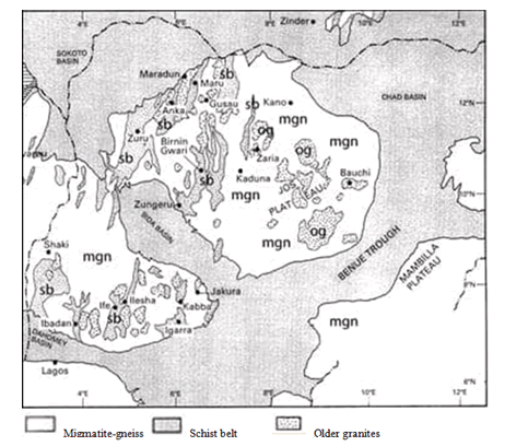
Igarra schist belt is one of the twelve schist belts discovered in Nigeria (Figure 1). The strati-volcanic successions in these schist belts are similar to those elsewhere that host important economic mineral deposits [1-12]. This, coupled with the historical assertion that alluvial gold was mined around Dagbala in Igarra area during the colonial days [13,14], led to Adepoju starting mineral prospecting study around Igarra schist belt via reconnaissance stream sediment geochemical survey of Orle Drainage system [15]. The region drained by the Orle Drainage system was selected for mineral-prospecting study based on the existence of structural guide to mineralization within it, as River Orle is characterized by trellis drainage pattern, notably at its origin. This reconnaissance geochemical stream sediment survey allowed the identification of Dagbala and Atte areas of the Igarra Schist Belt as more prospective to host important economic metallic mineral deposits [16,17]. The Dagbala-Atte district of the region was consequently recommended for a follow-up investigation. Adepoju accomplished the follow-up investigation through geochemical soil survey of the Dagbala-Atte district [18], which permitted the recognition of areas possibly underlain by potential mineralized rocks in the district [19-21]. Therefore, the areas envisioned to be possibly underlain by the potential mineralized rocks were suggested for detailed study comprising lineament analysis using remote sensing, detailed geologic mapping and lithogeochemical survey. Adepoju and Adepoju et al. have reported the results of the detailed study involving lineament analysis using remote sensing method and detailed geologic mapping in the study area [22].
Lithogeochemical data is otherwise known as rock geochemical data. The data comprises both major oxides and trace elements that are frequently used in geological mapping, tectonic studies and mineral exploration studies by supplying chemical information on alteration and mineralization patterns [23]. The basic aim of the statistical analysis of lithogeochemical data for mineral exploration is the recognition of areas of high concentrations (e.g., geochemical anomalies) of trace elements that may be speculative of mineral deposits. Host of statistical/geostatistical techniques have been applied to highlight the enhance trends or patterns called anomalies in lithogeochemical data. These anomalous populations oftentimes exhibit particular geologic processes such as fractionation, regional alteration, hydrothermal alteration and metasomatism. The techniques employed to recognize anomalous trends or populations in lithogeochemical data can be classified into univariate, bivariate, trivariate, multivariate and geostatistical methods. Techniques utilized for univariate data (histograms, box plots etc.) are relatively easy to calculate and simple to use in lithogeochemical samples. They involve identifying anomalous populations based on thresholds defined by changes in slope or groups of outliers on plots of cumulative frequency distributions (e.g., QQ plots, normal probability graphs) or dispersion box plots. Multivariate methods have the benefit of analyzing three or more elements at once, thereby give information on the association and structure among multiple elements. Correlation Matrix (CM), Factor Analysis (FA) and Principal Component Analysis (PCA), correspondence analysis and N-dimensional clustering are example of multivariate techniques [24-26]. A major disadvantage of most univariate and multivariate techniques is that spatial information is not used. This paper presents the results of the application of statistical examination to the lithogeochemical data obtain from analysis of rocks that underlain the areas of anomalous metal concentrations in follow up pedogeochemical surveys.
Igarra schist belt
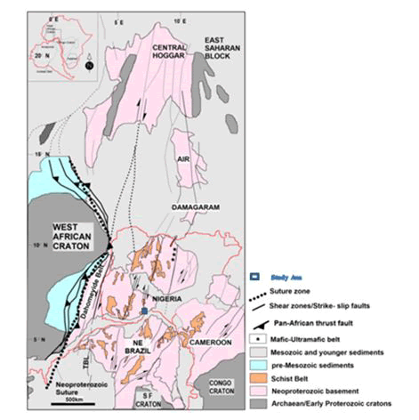
The Igarra schist belt is part of the western block of the Nigerian basement complex usually considered to be of Precambrian age. The basement complex rests east of the West African Craton and Northwest of the Congo-Kasai Craton in the Pan-African mobile belt (Figure 2). The area is considered to have developed as a result of modern plate tectonics processes [27,28].
A four-fold tectono-stratigraphic division [29,30], which explains best the field associations and age relationships among the lithologic units of the basement complex is as follows:
- The migmatite-gneiss-quartzite complex conventionally regarded as the basement sensu stricto;
- The Schist Belts which are supracrustal low to medium grade meta-sedimentary and meta-igneous rocks;
- The Pan African granitoids (Older Granites) and associated rocks such as charnockitic rocks and syenites; and
- The minor felsic and mafic intrusives.
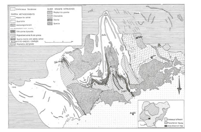
Igarra schist belt is underlain mainly by metaclastic rocks but has prominent carbonate and metaconglomerate units (Figure 3).
Geology of Dagbala-Atte District
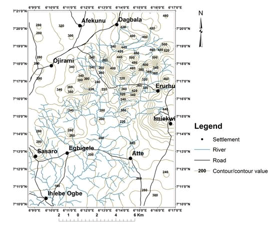
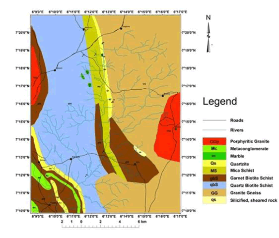
Dagbala-Atte District in the igarra schist belt lies between latitude 7° 10' to 7° 21' N and longitude 6° 09' to 6° 17' E (Figure 4).
It comprises the rocks of migmatite-gneiss-quartzite complex dominated by granitic gneisses to the east while the western part is composed mainly of metasediments (Figure 5).
A shear zone- Ojirami Shear Zone (OSZ)- occurs almost at the boundary between these two contrasting lithologies that appear to be separated by the silicified, sheared rock in places. The metasedimentary assemblage consists of quartz-biotite, garnet-biotite and mica schists with minor metaconglomerate, quartzites and marble. Both the metasediments and the granitic gneisses are intruded by porphyritic Pan African granite. The Pan African granite and the two earlier rock groups are intruded by minor felsic and mafic intrusives that include pegmatite, aplite, microgranite and lamprophyre.
Materials and Methods
Sample collection and geochemical analysis
The forty-five rock samples, employed for the present study comprise 10, 10, 13, 7 and 5 samples of Biotite Schist (BS), Granitic Gneiss (GG), Silicified Sheared Rock (SSR), Marble (MB), and Garnet Schist (GS), respectively, were collected and treated for geochemical analysis. Sample treatment entailed subjecting about 1 kg each of the rock samples to crushing in a jaw crusher which reduced the rock sample to millimeter size. The crushed sample was subjected to Ball Swing pulverization in order to obtain about 200-mesh particle size. Communition of the rock samples was carried out at the Department of Geology, University of Ilorin, Ilorin, Kwara State, Nigeria. The powdered rock sample was subjected to conning and quartering to collect representative samples of about eight gram each of the 45 samples that were packaged and sent to ACME Analytical Laboratories, Vancouver, Canada [31]. In the laboratory, the samples were oven dried at 600C and half a gram of each sample was digested with modified aqua regia (i.e. 1:1:1 mixture of HCl:HNO3:H2O). After mixing with the modified aqua regia, the samples were heated in the oven at a regular temperature of 65oC for twelve hours to extract metals from them. Later the contents were cooled and diluted to 20 ml with ultra-distilled water. The samples were thereafter allowed to stay for a period of about 12 hours for settling of the suspended matter. Aqua regia digestion method is employed because it can digest oxide and sulphide-minerals that most ore minerals exists [32]. Consequently, the supernatant liquid was transferred on to fresh test tubes and used for the analysis of thirty-seven elements namely, Ag, Al, As, Au, B, Ba, Bi, Ca, Cd, Co, Cr, Cu, Fe, Ga, Hg, K, La, Mg, Mn, Mo, Na, Ni, P, Pb, S, Sb, Sc, Se, Sr, Te, Th, Ti, Tl, U, V, W and Zn using the ultra-trace “Inductively-Coupled Plasma Mass Spectrophotometer” (ICP-MS). However, the results of ten trace elements, namely Ag, As, Au, Bi, Cu, Mo, Pb, Th, U, Zn were employed for the present study (Table 1).
| Sample No | Rock Type | Ag | As | Au | Bi | Cu | Mo | Pb | Th | U | Zn |
|---|---|---|---|---|---|---|---|---|---|---|---|
| DPR01 | BS | 60 | 35.4 | 3.1 | 0.28 | 32.13 | 1.07 | 11.11 | 10.8 | 1.1 | 115 |
| DPR02 | BS | 46 | 21 | 2.4 | 0.33 | 22.45 | 0.69 | 9.81 | 10.2 | 0.9 | 122.2 |
| DPR03 | BS | 93 | 1 | 1.1 | 0.17 | 63.49 | 1.53 | 5.12 | 8.5 | 0.9 | 53.8 |
| DPR04 | BS | 381 | 0.6 | 2.2 | 0.29 | 183.55 | 0.93 | 3.23 | 9.4 | 0.8 | 43.9 |
| DPR05 | BS | 35 | 0.7 | <0.2 | 0.21 | 12.01 | 0.96 | 4.26 | 11.4 | 1.4 | 40.9 |
| DPR06 | BS | 55 | 0.3 | 0.3 | 0.13 | 8.91 | 0.91 | 3.37 | 8.9 | 1 | 60.8 |
| DPR07 | BS | 59 | 10.9 | 1.3 | 0.41 | 36.26 | 0.36 | 4.01 | 10.9 | 1.1 | 116.2 |
| DPR08 | BS | 20 | <0.1 | <0.2 | 0.08 | 8.61 | 0.32 | 4.1 | 7.3 | 0.3 | 45.2 |
| DPR09 | BS | 22 | 0.8 | 3.8 | 0.25 | 13.92 | 1.02 | 4.22 | 11.9 | 1.4 | 41.1 |
| DPR10 | BS | 45 | 0.6 | 0.8 | 0.21 | 30.51 | 0.27 | 5.54 | 8.5 | 0.7 | 60.5 |
| DPR11 | GG | 20 | 1.2 | <0.2 | 0.1 | 19.17 | 1.02 | 5.13 | 20 | 3.5 | 46.9 |
| DPR12 | GG | 56 | 0.1 | <0.2 | <0.02 | 77.63 | 4.55 | 10.21 | 115.3 | 8.5 | 49.8 |
| DPR13 | GG | 29 | 0.4 | 1.2 | 0.05 | 21.42 | 1.67 | 5.46 | 17.3 | 1.8 | 33.4 |
| DPR14 | GG | 30 | 0.2 | 0.3 | 0.08 | 13.53 | 1.28 | 5.21 | 19.1 | 1.8 | 43.8 |
| DPR15 | GG | 10 | 0.9 | 0.3 | <0.02 | 11.91 | 1.58 | 3.27 | 1.4 | 0.4 | 34.9 |
| DPR16 | GG | 70 | 0.5 | 0.2 | 0.26 | 17.17 | 0.86 | 5.26 | 15.3 | 2.2 | 76.9 |
| DPR17 | GG | 15 | 0.3 | <0.2 | 0.04 | 10.93 | 1.03 | 2.05 | 2.1 | 1.4 | 56.2 |
| DPR18 | GG | 20 | 0.7 | 0.5 | 0.07 | 9.38 | 0.84 | 4.25 | 3.3 | 1.1 | 51.7 |
| DPR19 | GG | 33 | 1.4 | <0.2 | 0.11 | 24.05 | 1.1 | 4.8 | 18 | 3.3 | 46.5 |
| DPR20 | GG | 30 | 0.6 | 0.8 | 0.09 | 24.78 | 1.37 | 9.35 | 21 | 1.6 | 30.7 |
| DPR21 | SR | 61 | 0.8 | 0.8 | 0.14 | 38.13 | 1.23 | 3.78 | 1 | 0.4 | 1.8 |
| DPR22 | SR | 114 | 0.9 | 2.1 | 0.78 | 46.86 | 1.35 | 16.75 | 1.7 | 0.5 | 1.5 |
| DPR23 | SR | 21 | 0.9 | 1.5 | 9.07 | 16.62 | 1.13 | 9.79 | 5.1 | 11.7 | 4.4 |
| DPR24 | SR | 205 | 0.6 | 1.4 | 0.48 | 142.91 | 2.22 | 16.14 | 4.3 | 0.5 | 4.9 |
| DPR25 | SR | 223 | 1.6 | 2.8 | 0.35 | 157.98 | 3.59 | 16.07 | 5.8 | 0.8 | 8.2 |
| DPR26 | SR | 231 | 0.5 | 5.1 | 0.37 | 126.34 | 1.47 | 16.79 | 4.4 | 0.5 | 4.7 |
| DPR27 | SR | 240 | 1.6 | 1.5 | 1.56 | 159.37 | 1.48 | 23.78 | 0.7 | 0.3 | 7.2 |
| DPR28 | SR | 180 | 6.1 | 1.2 | 1.38 | 68.74 | 1.19 | 11.71 | 2.6 | 1.6 | 21.5 |
| DPR29 | SR | 119 | 1 | 1.5 | 0.63 | 17.4 | 1.31 | 16.17 | 0.7 | 0.1 | 1.7 |
| DPR30 | SR | 72 | 9.2 | 0.5 | 0.87 | 12.81 | 0.9 | 10.34 | 2.1 | 0.5 | 3.4 |
| DPR31 | SR | 77 | 8 | 0.4 | 0.93 | 10.52 | 0.41 | 9.97 | 1.9 | 0.3 | 2.9 |
| DPR32 | SR | 182 | 1.7 | 1.6 | 0.8 | 48.47 | 0.92 | 7.01 | 3.9 | 0.7 | 18.2 |
| DPR33 | SR | 197 | 1.7 | 0.5 | 0.8 | 48.35 | 0.8 | 7.27 | 3.9 | 0.6 | 19.7 |
| DPR34 | MB | 20 | 0.7 | 0.5 | <0.02 | 3.29 | 0.12 | 1.64 | 0.3 | 1.3 | 1.4 |
| DPR35 | MB | 10 | 0.6 | <0.2 | <0.02 | 3.01 | 0.11 | 1.5 | 0.2 | 1 | 1.3 |
| DPR36 | MB | 154 | 1.1 | 5.2 | <0.02 | 8.59 | 0.21 | 129.73 | 0.3 | <0.1 | 54.7 |
| DPR37 | MB | 209 | 1.6 | 8.8 | <0.02 | 2.1 | 0.19 | 18.68 | 0.1 | <0.1 | 1.7 |
| DPR38 | MB | 3 | 0.7 | 2.7 | 1 | 1.98 | 0.23 | 4.33 | 1 | 1.6 | 2.9 |
| DPR39 | MB | 6 | 3.1 | <0.2 | <0.02 | 1.08 | 0.47 | 5.77 | 0.1 | 1.5 | 3.1 |
| DPR40 | MB | 8 | 2.8 | <0.2 | <0.02 | 1.19 | 0.18 | 1.19 | 0.3 | 1.5 | 1.9 |
| DPR41 | GS | 13 | 0.2 | 4.8 | 0.09 | 34.53 | 0.58 | 4.74 | 9.3 | 1.3 | 95 |
| DPR42 | GS | 96 | <0.1 | 2.3 | 0.52 | 275 | 0.6 | 4.24 | 4 | 0.7 | 101.7 |
| DPR43 | GS | 21 | <0.1 | 1.8 | 0.3 | 14.22 | 0.57 | 5.06 | 2.8 | 0.5 | 95.1 |
| DPR44 | GS | 50 | 0.4 | <0.2 | 0.23 | 33.82 | 0.57 | 5.11 | 9.6 | 1.3 | 94.3 |
| DPR45 | GS | 13 | 0.2 | <0.2 | 0.36 | 15.87 | 0.63 | 5.51 | 3.4 | 0.7 | 103.3 |
Table 1: Concentrations of the elements for the present study in rocks of the district- Ag and Au in ppb, other elements in ppm.
Statistical analysis
Univariate and multivariate statistical analyses were carried out employing the graphical method of box plots and factor analysis, respectively. The statistical data analyses were executed using software package, Minitab-16, in a DELL Inspiron 5521 Laptop computer. A dispersion box plot allows different characteristics to be put on the same graphs. These characteristics include 1st Quartile (Q1), 2nd Quartile (Q2 or median), 3rd Quartile (Q3), Interquartile Range( IQR) (i.e. the difference between the 3rd Quartile and the first Quartile, Q3–Q1), range (the scale of the graph), upper threshold (Q3+1.5 IQR), lower threshold (Q1-1.5 IQR) and outliers, i.e. the points above the upper threshold (anomalies) and below the lower threshold (negative anomalies) if exist among the data sets. Thus the box plot is the only graph capable of synthesizing different statistical characteristics [33].
Available literature on FA suggests that the technique is useful in evaluating multivariable geochemical data of various types [34,35]. Commonly, it is possible to interpret the resulting multivariables (factors) in geological terms such as processes or types. Thus one can investigate the extent to which individual samples reflect a particular process or end member rock type. FA is a mathematical method for determining interrelation of variables (trace elements in this case) using R-mode technique or Q-mode technique in a set of apparently complex data. R-mode technique is the most commonly used in geochemical exploration and was consequently adopted for this study. R-mode FA examines the relationship among variables by analyzing a matrix of simple correlation coefficients for all pairs of variables considered.
Results
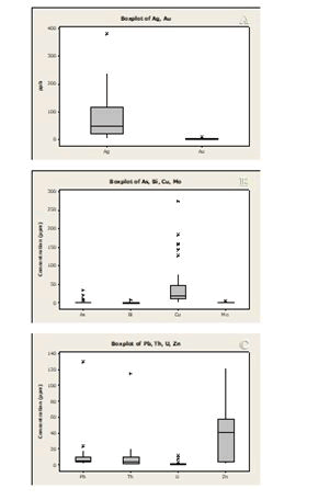
Figure 6 shows the box plots constructed using the raw data of the ten trace elements employed for this study. These raw data box plots show that there is a very large disparity between the median values and maximum values, with an even lower means for the elements. The result is a longer whisker above the mean and a shorter one below it, which implies that the elements’ values greatly depart from the mean. This is also an indication of the extreme variability of geochemical data. This trend in any data set indicates the data is obviously non-normal.
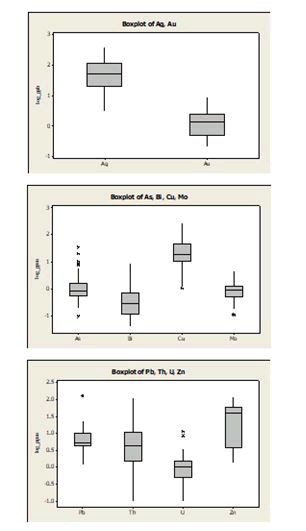
A log transformation gives a more refined dataset with both the maximum and minimum values evenly distributed about the mean values (Figure 7).
Figure 6 also reveal the presence of positive anomalies for all the ten elements for this study but Zn, while no negative anomalies exists for any elements in the study area. There exists anomalies at 1, 5, 1, 2, 6, 2, 2, 1 and 3 number of site(s) for Ag, As, Au, Bi, Cu, Mo, Pb, Th and U, respectively (Table 2).
| Element | Threshold | AS | Value in anomalous site | Rock type |
|---|---|---|---|---|
| Ag | 240 | 1 | 381 | BS |
| As | 3.1 | 5 | 6.1, 9.2, 10.9, 21,35.2 | SSR, SSR, BS, BS, BS |
| Au | 5.2 | 1 | 8.8 | MB |
| Bi | 0.93 | 2 | 1.56, 9.07 | SSR, SSR |
| Cu | 77.63 | 6 | 126.34, 142.91, 157.98, 159.27, 183.55, 275.0 | SSR,SSR, SSR, SSR, BS, GS |
| Mo | 2.22 | 2 | 3.59, 4.55 | SSR, GG |
| Pb | 18.68 | 2 | 23.78, 129.73 | SSR, MB |
| Th | 21 | 1 | 115.3 | GG |
| U | 2.2 | 3 | 3.5, 8.5, 11.7 | GG, GG, SSR |
For the FA, all the ten elements were used because none contains censored data (i.e. values below or above analytical detection limit, DL) in greater than 30 % of the sampling sites. Ag, Cu, Mo, Pb, Th, U and Zn have no censored value. As, Au, Bi and U have in 3, 11, 8 and 2, respectively of their sites where they have values below their lower DLs all of which are less than 30 % of the 45 sampling sites employed for this study. For these elements with censored data in less than 30 % of their sampling sites, values equal to 66 % of their lower DLs are substituted at those sites. Another important requirement for multivariate analyses is that normal data is employed and in the case of Dagbala-Atte District [36], the logarithmically transformed data are normal (Figure 6), while the raw data are non-normal (Figure 5). Therefore, logarithmically transformed data are used for computation of the FA (Table 3a).
| Variable | Factor 1 | Factor 2 | Factor 3 | Factor 4 | Communality |
|---|---|---|---|---|---|
| Ag | 0.479 | -0.742 | 0.058 | -0.001 | 0.783 |
| As | -0.076 | -0.19 | 0.095 | -0.899 | 0.858 |
| Au | 0.085 | -0.752 | -0.05 | -0.206 | 0.618 |
| Bi | 0.63 | -0.204 | 0.105 | -0.429 | 0.634 |
| Cu | 0.815 | -0.375 | -0.209 | 0.124 | 0.863 |
| Mo | 0.859 | -0.026 | -0.056 | 0.115 | 0.754 |
| Pb | 0.219 | -0.78 | 0.032 | -0.114 | 0.671 |
| Th | 0.656 | 0.251 | -0.639 | 0.042 | 0.904 |
| U | 0.378 | 0.791 | -0.191 | -0.17 | 0.835 |
| Zn | 0.163 | 0.072 | -0.953 | 0.102 | 0.95 |
| Variance | 2.6895 | 2.6383 | 1.4266 | 1.117 | 7.8713 |
| % Var | 26.9 | 26.4 | 14.3 | 11.2 | 78.8 |
Table 3a: Rotated factor loadings and communalities, Orthomax Rotation with Gamma= 0.00.
The table displays the four-factor Orthomax R-mode Factor Analysis of the log data for the study area. The total explained variance of the four-factor model is 78.8 % (Table 3a). Factor 1 is Mo-Cu-Th-Bi-Ag factor (Table 3b).
| Factor | Element | Eigen Value |
|---|---|---|
| F-1 | Mo-Cu-Th-Bi-Ag | 26.9 |
| F-2 | U | 26.4 |
| F-3 | Zn-Th | 14.3 |
| F-4 | As-Bi-Au | 11.2 |
Table 3b: Element association of the four-factor model.
It accounts for 26.9 % of the four factor model in the studied rock of the area. It probably connotes association of these elements in a rock of the study area, with possible mineralization of some of them in the rock. Factor 2 is U factor that is antipathetically related with Pb, Au and Ag, accounting for 26.4 % of the four-factor model in the rocks of the area. It may signify that U mineralization if exist in the study area may not associate with Pb, Au and Ag in the same rock. Factor 3 is Zn-Th factor with limited association with Cu and U, which account for 14.3 % of the four-factor model in the considered rocks for the present study. It may imply that Zn and Th are associated in some lithological units in the study area whereas; they associate with Cu and U in less number of rock still. Factor 4 is as factor that is antipathetically related with most of the elements in the rocks of the study area. It might imply that as can serve as a pathfinder element for mineralization in highly restricted lithological units, such as the MB and SR rock in the study area.
Discussion
In this section the ten elements employed for the present study are statistically discussed, bearing on their average abundance in the earth crust and all rocks (AR) employed for the present study as well as ranges and average abundance of the element in each of these rocks in Dagbala-Atte District (Table 4).
| El | EC | Dagbala-Atte District | ||||||||||
|---|---|---|---|---|---|---|---|---|---|---|---|---|
| DA (n =45) | BS (n=10) | Granite gneiss | Sheared rock | Marble | Garnet schist | |||||||
| (n=10) | (n=13) | (n=7) | (n=5) | |||||||||
| Aver | Aver | Ran | Aver | Ran | Aver | Ran | Aver | Ran | Aver | Ran | Aver | |
| Ag | 70 | 81.2 | 20-381 | 81.6 | Oct-70 | 31.3 | 21-240 | 147.8 | 3-209 | 58.6 | 38.6 | |
| As | 1.8 | 1.44359 | 0.3-35.4 | 0.67 | 0.1-1.4 | 0.63 | 0.5-9.2 | 2.662 | 0.6-3.1 | 1.514 | 0.2667 | |
| Au | 4 | 1.92059 | 0.3-3.8 | 1.88 | 0.2-1.2 | 0.55 | 0.4-5.1 | 1.608 | 0.5-8.8 | 4.3 | 2.967 | |
| Bi | 0.17 | 0.63389 | 0.08-0.41 | 0.24 | 0.04-0.26 | 0.1 | 0.14-9.07 | 1.397 | 0.02 | 0.3 | ||
| Cu | 55 | 42.9109 | 8.61-183.55 | 41.2 | 9.38-77.63 | 23 | 10.52-159.37 | 68.8 | 1.08-8.59 | 3.034 | 74.7 | |
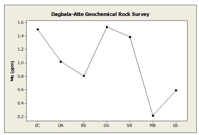
| Mo | 1.5 | 1.01822 | 0.32-1.53 | 0.81 | 0.84-4.55 | 1.53 | 0.41-3.59 | 1.385 | 0.11-0.47 | 0.216 | 0.59 | |
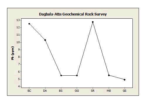
| Pb | 12.5 | 10.2851 | 3.23-11.11 | 5.48 | 2.05-10.21 | 5.499 | 3.78-23.78 | 12.74 | 1.19-129.73 | 23.3 | 4.92 | |
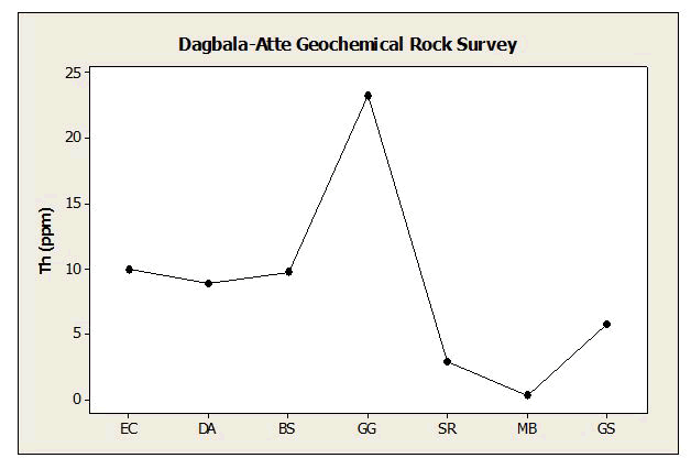
| Th | 10 | 8.89111 | 7.3-11.9 | 9.78 | 1.4-115.3 | 23.3 | 0.7-5.8 | 2.931 | 0.1-1 | 0.329 | 5.82 | |
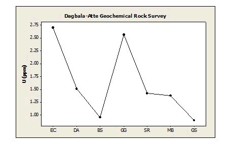
| U | 2.7 | 1.51395 | 0.3-1.1 | 0.96 | 0.4-8.5 | 2.56 | 0.1-11.7 | 1.423 | 1-1.6 | 1.38 | 0.9 | |
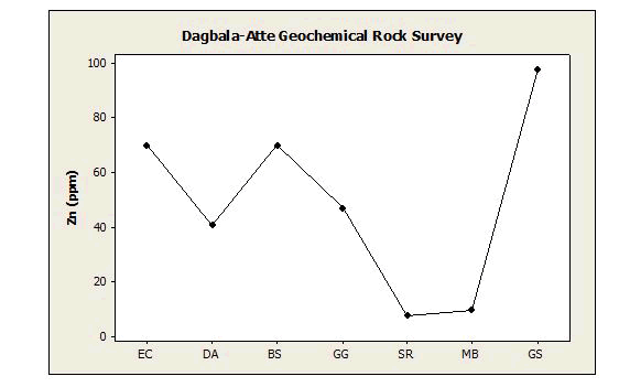
| Zn | 70 | 40.5978 | 40.9-122.2 | 70 | 30.7-76.9 | 47.08 | 1.5-21.5 | 7.7 | 1.3-54.7 | 9.57 | 97.88 | |
Table 4: Average Abundance of Elements in Earth Crust (EC), after and All the Rocks of Dagbala-Atte District Employed (DA), as well as Ranges and Average Abundance of Element in Each Rock Types of Dagbala-Atte District (all elements in ppm except, Au and Ag in ppb) [37].
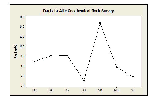
Ag (Silver): Ag was detected in all the 45 rock samples employed for the present study. The contents of the elements range from 3 ppb to 381 ppb with a mean of 81.2 ppb. The selected threshold for Ag is 240 ppb which throws up only one anomalous sample with label DPR04 (381 ppb). Other samples with relatively high concentrations of Ag are DPR25 (223 ppb), DPR26 (231 ppb), DPR27 (240 ppb) and DPR36 (209 ppb). These anomalous- and high-value samples are those of BS (DPR04), SR (DPR25, DPR26 and DPR27) and MB (DPR37). However, when compared with the average crustal abundance, the Ag values in the study District is high, which might indicate a possible occurrence of Ag mineralization. A comparison of the average contents of Ag among the different lithologies, i.e. BS, GG, SR, MB and GS, that underlie the district (Table 4, Figure 8) revealed that the anomalous value recorded for BS be spurious and the SR could be the number-one suspect for Ag mineralization in the study area. The association of Mo-Cu-Th-Bi-Ag in Factor 1 (Table 3) might suggest that Mo, Cu, Th and Bi occur together in the suspected Ag mineralization in the silicified sheared rock [38].
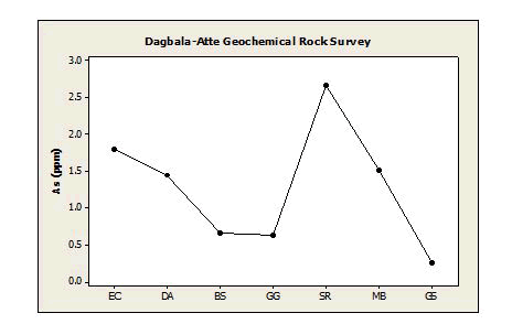
As (Arsenic): As was detected in 43 samples; it was present in amount less than the instrument’s lower detection limit of 0.1 ppm in only 3 samples. Where it was detected its values ranged from 0.1 to 35.4 ppm with a mean of 2.94 ppm. The threshold value for as in this District is 3.1 ppm, which revealed six anomalous values in samples DPR01 (35.4 ppm), DPR02 (21 ppm), DPR07 (10.9 ppm), DPR28 (6.1 ppm), DPR30 (9.2 ppm) and DPR31 (8 ppm). These anomalous samples are those of BS (DPR01, DPR02 and DPR07) and SR (DPR28, DPR30 and DPR31). When the mean value of As in DA is compared with its average abundance in the EC (Table 4), the as concentration in the District is low except for the SR (Figure 9).
Thus, the anomalous values of as recorded in this particular rock probably suggest that it is the host rock for some epigenetic sulfide deposits in which as occurs possibly in association with Mo, Cu, Th, Bi, and Ag, as suggested by Factor 1. It can possibly be used as a pathfinder element for the exploration for the possible sulphide mineralization in the silicified sheared rock. The strong negative factor displayed by as and Bi in Factor 4 (Figure 3) buttresses this point. The weak negative factor between us and Au in the same factor also points to the fact that as has limited association with the possible gold-bearing rock in the study area.
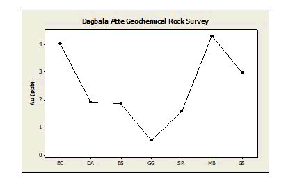
Au (Gold): Au was detected in thirty-four of the forty-five rock samples studied. It occurred below the detection limit of 0.2 ppb in other 11 samples. Where it is detected, it ranges in concentration from 0.2 to 8.8 ppb with a mean of 1.9 ppb. With the threshold value of 5.6 ppb selected for Au, one anomalous value occurs in sample DPR36 (8.8 ppb). Other samples with high Au contents include DPR35 (5.2 ppb), DPR26 (5.1 ppb), DPR40 (4.8 ppb) and DPR09 (3.8 ppb) in the District. These samples are those of BS (DPR09), SR (DPR26), MB (DPR35 and DPR36) and GS (DPR40). Compared with the average abundance of Au in the crust (Table 4), its concentration in the rocks of the district is generally on the low side (Figure 10).
However, the ubiquity and high contents of Au in all the samples of the silicified sheared rock might indicate its possible limited association with the suspected sulphide mineralization in this particular rock. Also, the higher Au concentration in some MB samples could result from the alkaline nature of marble environment that could precipitate gold and other metals from hydrothermal fluids. Therefore, the prime suspect for Au mineralization in the study area is the MB deposit along the shear zone where sample DPR36 was taken. The negative As-Bi-Au Factor 4 suggests that as and Bi has application as pathfinder elements for Au in the area.
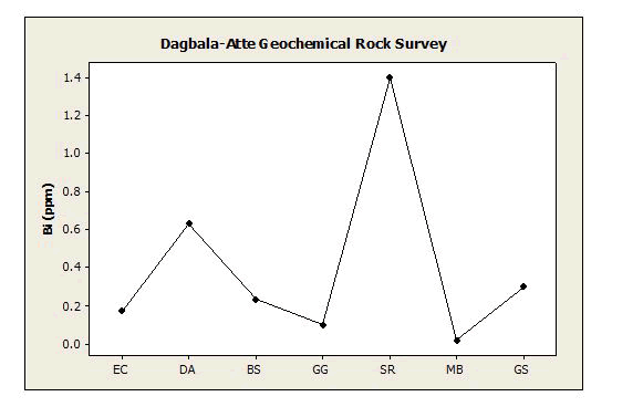
Bi (Bismuth): Bi has a fairly wide distribution in the study area and is present below the lower limit of detection in nine of the rock samples. The detected values range from 0.04 to 0.285 ppm with a mean of 0.63 ppm. Above the threshold value of 0.93 ppm three anomalous values exist in samples DPR23 (9.07 ppm), DPR27 (1.58 ppm) and DPR28 (1.38 ppm). Two other fairly high-value sample are DPR31 (0.93 ppm) and DPR30 (0.87 ppm). All the three anomalous values and the two high values of Bi are recorded from the samples of SR. The average Bi value for the DA of the study area (Table 4) is much higher than its average crustal abundance (Figure 11).
Bi belongs in Factor 1 is Mo-Cu-Th-Bi-Ag factor, which is interpreted as indicating potential occurrence of Bi minerals associated with ores of Mo, Cu, and Ag in the study area. Bi is useful as a pathfinder for sulphide ore. There are high contents of Bi in the SR, as reflected by its much higher average than those of other rock types. This observation, therefore buttresses the earlier opinion that the rock could be the possible host for the sulphide ore, and Factor 1 is indeed indicative of mineralization in the SR in the District.
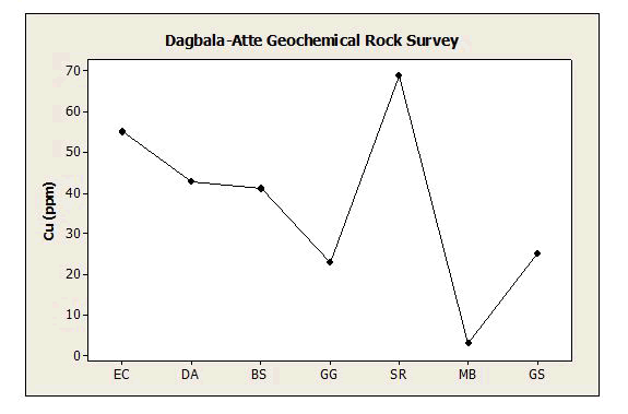
Cu (Copper): Cu is widely distributed in the District as it is detected in all the samples in concentrations ranging from 1.08 to 275 ppm with a mean of 42.9 ppm. With the threshold value of 77.63 ppm, five anomalous values of Cu exist in the rock samples DPR04 (183.55 ppm), DPR24 (142.91 ppm), DPR26 (126.34), DPR27 (159.88) and DPR41 (275 ppm) in the area. These anomalous samples are essentially those of SR. Compared with the average abundance of Cu in the EC (Table 4), its concentration in the rocks of the study area is generally lower except in the SR, where it is slightly higher (Figure 12).
Therefore, the anomalous Cu values in the SR and its association with Factor 1 could be due to its mineralization, albeit slightly, in the silicified rock.
Mo (Molybdenum): Mo is present in detectable amounts in all the forty-five rock samples. It ranges in concentration from 0.11 to 4.55 ppm with a mean of 1.02 ppm. Above the selected threshold value of 2.22 ppm, two anomalous values exist in samples DPR12 (4.55 ppm) and DPR25 (3.59 ppm). Other high Mo value samples include DPR13 (1.67 ppm), DPR15 (1.58 ppm) and DPR24 (2.22 ppm). These anomalous and high Mo value samples are those of GG (DPR12, DPR13 and DPR15) and SR (DPR24 and DPR25). A comparison of the average abundance of Mo in EC with its average concentrations in DA (Figure 13) shows that the concentration of Mo in the latter is generally low.
This is possibly an indication that Mo-mineralization is lacking in the district, however its association in Factor 1 might indicate that it could serve as a pathfinder element for the suspected Ag-Cu mineralization in the SR of the study area.
Pb (lead): The distribution of lead in the rocks of the District is wide because all the samples analyzed contain Pb in contents that range from 1.19 to 129.73 ppm with a mean of 10.29. With the selected threshold of 18.68 ppm, two anomalous values occur at samples DPR27 (23.78 ppm) and DPR35 (129.73 ppm). Other relatively high Pb values occur in samples DPR22 (16.75ppm), DPR26 (16.79 ppm) and DPR36 (18.68 ppm). These samples of high and anomalous values are of silicified sheared rock (DPR22, DPR26 and DPR27) and marble (DPR35 and DPR36). Compared with the average abundance of Pb in EC (Table 4), the mean Pb concentration of the rocks is low, except that of the silicified sheared rock that is comparable (Figure 14).
This indicates that there might not be Pb mineralization in any of the rock units employed for this particular study in the district but the element might possibly be associated with the suspected complex sulphide mineralization in the SR. Also the Pb anomalous concentration detected in the residual soils in the southwestern part of Dagbala-Atte District that is underlain by the BS-MC intercalation, might be due to either anomalous concentration or mineralization of Pb in MC rather than BS in that part of the study area.
Th (Thorium): Th concentrations range from 0.1 to 115.3 ppm with a mean of 8.9 ppm in the rocks of the District. In the study area, one anomalous value exists above the threshold value of 21 ppm in sample DPR12 (115.3 ppm). Other rock samples, which show fairly high Th values include DPS11 (20 ppm), DPS14 (19.1 ppm), DPS19 (18 ppm) and DPS20 (21 ppm). These sample sites are spread within the granitic gneiss. A comparison of the average value of Th in DA with its average crustal abundance (Table 4) shows that the element is moderately distributed in the study area. Nevertheless, a much higher Th average in the granitic gneiss than its average crustal abundance exists in the District (Figure 15). These could indicate enrichment of Th in the GG of the District.
U (uranium): U is fairly widely distributed in the rocks of the District. It is detected in appreciable amounts in forty-two samples and its values in only three samples are less than 0.1 ppm, the lower limit of detection of the analytical instrument. Where it is detected U contents range from 0.1 ppm to a peak value of 11.7 ppm with a mean of 1.5 ppm. With the selected threshold of 2.2 ppm, four anomalous values occur in samples DPR11 (3.5 ppm), DPR12 (8.5 ppm), DPR19 (3.3 ppm) and DPR23 (11.7 ppm). Another fairly high U content sample is DPR16 (2.2 ppm). These anomalous and fairly high U containing rock samples are obtained from the GG, except DPR23, which is from the SR of the District. The average U values obtained for the rocks in this District, as compared with its average abundance in the EC (Table 4), shows that U content is lower in the study area. This might indicate lack of U mineralization in all the main rocks units employed for the present study. However, GG shows a much higher U average than other rocks, which may be a pointer to the expected U enrichment in this rock (Figure 16).
The pedogeochemical survey for U mineralization carried out in the district that indicated possible occurrence of a U mineralization in this part could be drawing an inference to the tiny pegmatite veins associated with this rock.
Zn (zinc): Zn shows appreciable contents in all the 45 rock samples employed for this geochemical survey. The concentrations of Zn in the rocks of this District range from 1.3 to 122.2 ppm with a mean of 40.6 ppm. The selected threshold of 122.2 ppm revealed no anomalous values in all the samples. However, relatively high Zn values occur in samples DPR01 (115 ppm), DPR02 (122.2 ppm), DPR07 (116.2 ppm), DPR41 (101.7 ppm) and DPR45 (103.3 ppm). These samples are those of biotite schist and garnet schist, indicating that there is enrichment of zinc in the schist of the schist belt. However, the zinc values in the rocks of the District are generally low in comparison with the average crustal abundance of zinc (Figure 17).
It seems that the low Zn content could be due to a combination of serious depletion of Zn in the SR and MB, only a fair enrichment of Zn in the BS and fair depletion of Zn in the GG. Nevertheless, the Zn anomalous concentration detected in the residual soils in the southwestern part of Dagbala-Atte District that is underlain by the BS-MC intercalation, might be due to either anomalous concentration or mineralization of Zn in MC rather than BS in that part of the study area.
Conclusion
From the study, two types of mineralization are suspected and two inferred. The two suspected mineralization include Au mineralization in the marble deposit near Dagbala, and Ag-Cu mineralization in the silicified sheared rock near Dagbala, Ojirami, Erurhu and Atte both along the shear zone in the district. The two inferred mineralization include U mineralization in the pegmatite veins near Dagbala, and Pb-Zn mineralization in the metaconglomerate near Ojirami. Comprehensive exploration of the metal bearing rocks and detailed study of the potential mineralized rocks are recommended.
References
- Elueze AA (1977) Geological and geochemical studies in the Ilesha schist belt in relation to gold mineralization. Unpubl M Phil thesis, University of Ibadan, Nigeria.
- Odeyemi IB (1976) Preliminary Report on the Field Relationships between the Basement Complex Rocks in Igarra, Midwestern Nigeria. In: Kogbe CA, Ed, Geology of Nigeria, Elizabethan Publ Co Lagos, Lagos, pp59-63.
- Odeyemi IB. Lithostratigraphy and structural relationships of the Upper Precambrian Metasediments in Igarra area, southwestern Nigeria. In: Oluyide PO, Mbonu WO, Ogezi AEO, Egbuniwe IG, Ajibade AC and Umeji AO, Eds., Precambrian Geology of Nigeria, Geological Survey of Nigeria Publication, Kaduna South, 1988, pp111-125.
- Moneme PC, Scott PPW, Dunham AC (1982) Manganese mineralization at Tundun Kudu, Zaria district, North-central Nigeria.J Min Geol 19:30-42.
- Hockey RD, Sacchi R, de Graaff WPFH, Muotoh EOG (1986) The geology of Lokoja-Auchi area; explanation of 1: 250,000 Sheet 62. Geol Surv Nigeria Bull 39:71.
- Adekoya JA (1998) Precambrian iron-formation of Northwestern Nigeria. ln: Oluyide PO, Mbonu WC, Ogezi AE, Egbuniwe IG, Ajibade IC and Umeji AC (Eds.) Precambrian Geology of Nigeria, Geological Survey of Nigeria, pp195-210.
- Adekoya JA (1995) Supergene Fe Mn enrichment in the Precambrian iron formation, Birnin Gwari, northwestern Nigeria. J Min Geol 31:63-72.
- Annor AE, Olobaniyi SB, Mucke A (1996) A note on the geology of Isanlu area in the Egbe-Isanlu Schist Belt, SW Nigeria. J Min Geol 32:47-51.
- Oyinloye AO, Steed GM (1996) Geology and Geochemistry of Iperindo primary gold deposit, Ilesha Schist Belt, Southwestern Nigeria. Trans Instn Min Metall (Sect B Appl Earth Sci) 105:B74-B81.
- Olobaniyi SB, Annor AE (1997) The occurrence of Komatiitic Ultramafic schist in the Egbe-Isanlu schist belt, SW Nigeria and its age implications. Abstract Nig Min Geo Soc 33rd Annual Conference, p12-13.
- Garba I (2000) Origin of Pan African mesothermal gold mineralization at Bin Yauri, Nigeria. J African Earth Sci 33:433-449.
- Egbuniwe IG, Ocan OO (2004) Selection of Fieldwork Areas for Teaching/Training: Igarra Area as an Example. Proceedings of Field Mapping Standardization Workshop, Ibadan University Press, Ibadan, 79-95.
- Adekoya JA (1978) Gold deposits in Nigeria: a summary of available information (Special Report). Unpublished Geological Survey of Nigeria Report, Kaduna South.
- Adekoya JA (1999) Rocks and stones: treasure house for national prosperity. Inaugural Lecture Series 19, FUT, Akure, 1999.
- Adepoju MO (2004) Reconnaissance geochemical stream sediment survey of Orle drainage system, Edo State, Nigeria. Unpubl M Tech Thesis, Fed Univ of Tech Akure, 2004.
- Adepoju MO, Adekoya JA (2008) Statistical analysis of reconnaissance geochemical data from Orle district, southwestern Nigeria. Glob J Geol Sci 6:63-74.
- Adepoju MO, Adekoya JA (2011) Reconnaissance geochemical study of a part of Igarra schist belt, southwestern Nigeria. Ife J Sci 13:175-92.
- Adepoju MO (2017) Geological and geochemical exploration studies of Dagbala-Atte District in Igarra Schist Belt, Southwestern Nigeria. Ph D Dissertation, Federal University of Technology, Akure, 2017.
- Adepoju MO (2019) Geochemical soil survey for base and precious metals in Dagbala-Atte District, southwestern Nigeria. Int J Geosci 10:141-159.
- Adepoju MO, Adekoya JA, Odeyemi IB (2018) Statistical evaluation of soil geochemical data from Dagbala-Atte District in Igarra Schist Belt, Southwestern Nigeria. Geoinform Geostat 6:1–11.
- Adepoju MO, Adekoya JA, Awoniran DR (2019) Exploration for ferrous metals using geochemical soil survey in Dagbala-Atte District, southwestern Nigeria. Int J Adv Res sci Eng Technol 6:100 - 111.
- Adepoju MO, Odeyemi IB, Akinluyi FO (2021) Landsat 8 lineament analysis for epigenetic mineralization in parts of Igarra Schist Belt, Southwestern Nigeria. Remote Sens Earth Syst Sci 4:76-86.
- Turner DC (1983) Upper Proterozoic Schist Belts in the Nigerian sector of the Pan-African Province of West Africa. Precambrian Res 21:55-79.
- Grunsky EC, Easton RM, Thurston PC, Jensen LS (1992) Characterization and statistical classification of Archean volcanic rocks of the Superior Province using major element geochemistry in geology of Ontario. Ont Geol Surv 4:1347-1438.
- Jimenez Espinosa R, Sousa AJ, Chica O(1993) Identification of geochemical anomalies using principal component analysis and factorial kriging analysisAmsterdam. J Geochem Explor 46:245-256.
- Grunsky EC (1997) Numerical techniques and Strategies for the interpretation of geochemical data. In: Current Topics in GIS and integration of Exploration datasets, Short Course, Exploration’97, Workshop, Ottawa, p146.
- Burke KC, Dewey FJ (1972) Orogeny in Africa. In: Dessuvagie and Whiteman (Eds); African Geology, Ibadan University Press, pp583-608.
- Bertrand JML, Caby R (1978) Geodynamic evolution of the Pan-African Orogenic Belt: A new interpretation of the Hoggar Shield (Algerian Sahara). Geol Rundsch 67:357-388.
- Adekoya JA (1991) The geology of the banded iron-formations in the Precambrian Basement Complex of Northern Nigeria. Unpubl Ph D Thesis. University of Ibadan, Nigeria.
- Adekoya JA, Kehinde-Phillips OO, Odukoya AM (2003) Geological distribution of mineral resources in southwestern Nigeria. In: Prospects for investment in mineralresources of southwestern Nigeria, A A Elueze (ed), Special Publication of Nigerian Mining and Geosciences Society, pp. 1 – 13.
- Hall GEM, Bonham-Carter GF (2014) Geochemistry: Exploration, Analysis. geea.lyellcollection 14: 99-123.
[Crossref]
- Rose AW, Hawkes HE, Webb JS, Geochemistry in mineral exploration, 3rd Edition, Academic Press, London, p 711.
- Carranza EJM (2008) Exploratory Analysis of Geochemical Anomalies. In: Hale M Geochemical Anomaly and Mineral Prospectivity Mapping. Handbook of Exploration and Environmental Geochemistry. Netherlands; 2008. pp, 51-83.
- Bammeke BO (1992) Computer-aided factor analysis of stream sediment geochemical data from Igbo-Ora greenstone-granite complex, south-west Nigeria. J Min Geol 28:113–117.
- Odokuma AO, Adekoya JA (2013) Factor Analysis of Stream Sediment Geochemical Data from Onyami Drainage System, Southwestern Nigeria. Int J Geomat Geosci 4:656-661.
- Sadeghi M, Billay A, Carranza EJM (2015) Analysis and mapping of soil geochemical anomalies: implications for bedrock mapping and gold exploration in Giyani area, South Africa. J Geochem Explor 154:180-193.
[Crossref]
- Levinson AA (1974) Introduction to exploration geochemistry. OSTI.GOV, United States.
- Adepoju MO, Okonkwo CT, Bolarinwa AT (2021) Pedogeochemical survey for uranium mineralization in parts of Igarra Schist Belt, southwestern Nigeria. Ife J Sci 23:191-204.
 Spanish
  Chinese
  Russian
  German
  French
  Japanese
  Portuguese
  Hindi
Hindi 